This Was The Warmest Christmas On Record For Much Of The Midwest
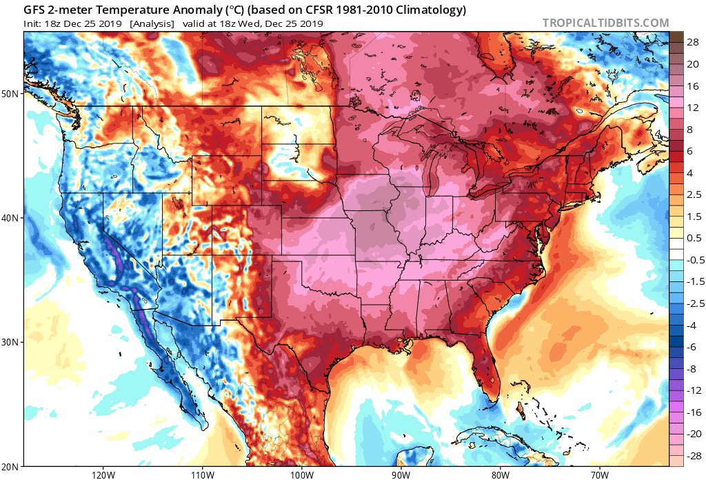
The sun just set on one of the warmest Christmases in recent memory. The abnormal blast of winter warmth stretched from the Rocky Mountains to the East Coast, with the bulk of the above-average temperatures focused on the central part of the country. Temperatures climbed as much as 30°F above normal in parts of the central United States on Wednesday afternoon, leading several cities to their warmest December 25 on record.
A strong ridge of high pressure over the eastern two-thirds of the United States is responsible for the current burst of above-average temperatures. The most significant and widespread warmth occurred on Wednesday afternoon, but the unseasonably comfortable temperatures will stretch into Thursday and Friday for some in the eastern part of the country.
This kind of warmth doesn’t seem like much. It’s pretty nice out! How often do you get to throw the windows open on Christmas and air out the house before the cold of winter sets in? However, just because it’s comfortable doesn’t mean that this isn’t an unusually warm stretch for late December. It’s easy to lose sight of the fact that it’s not supposed to feel like late September in late December when that eye-popping temperature anomaly’s practical effect is “ooh, this is comfy.”

Dozens of reporting stations broke their daily high temperature record for December 25, cementing this as the warmest Christmas on record for many parts of the Midwest. The animation above shows the high temperatures that fell (in red) on Wednesday.

Moline, Illinois, saw its warmest December 25 on record, topping out with a high of 62°F. That doesn’t seem like much until you consider that the city’s average high for this date is 32°F. The high in St. Louis, MO, clocked in at 70°F, which is also a solid 30°F above what the city should see this time of year.
.tg {border-collapse:collapse;border-spacing:0;}
.tg td{font-family:Arial, sans-serif;font-size:14px;padding:10px 5px;border-style:solid;border-width:1px;overflow:hidden;word-break:normal;border-color:black;}
.tg th{font-family:Arial, sans-serif;font-size:14px;font-weight:normal;padding:10px 5px;border-style:solid;border-width:1px;overflow:hidden;word-break:normal;border-color:black;}
.tg .tg-2b7s{text-align:right;vertical-align:bottom}
.tg .tg-ee30{font-weight:bold;background-color:#ffffff;border-color:inherit;text-align:center;vertical-align:middle}
.tg .tg-y86l{font-weight:bold;background-color:#ddf7e8;color:#fe0000;border-color:#000000;text-align:center;vertical-align:middle}
.tg .tg-nb60{font-weight:bold;background-color:#ddf7e8;border-color:inherit;text-align:center;vertical-align:middle}
.tg .tg-pl3c{font-weight:bold;background-color:#ffffff;color:#333333;border-color:inherit;text-align:center;vertical-align:middle}
.tg .tg-ow25{font-weight:bold;background-color:#27ae60;color:#ffffff;border-color:#000000;text-align:center;vertical-align:middle}
.tg .tg-zp1r{font-weight:bold;background-color:#ffffff;color:#fe0000;border-color:#000000;text-align:center;vertical-align:middle}
| City | Average High for Dec. 25 |
Observed High on Dec. 25, 2019 |
Departure From Average |
|---|---|---|---|
| St. Louis, MO | 40°F | 70°F | +30°F |
| Moline, IL | 32°F | 62°F | +30°F |
| Kansas City, MO | 38°F | 66°F | +28°F |
| Chicago (MDW), IL | 33°F | 61°F | +28°F |
| Wichita, KS | 42°F | 68°F | +26°F |
| Indianapolis, IN | 36°F | 62°F | +26°F |
| Oklahoma City, OK | 49°F | 70°F | +21°F |
| Memphis, TN | 50°F | 70°F | +20°F |
| Buffalo, NY | 34°F | 50°F | +16°F |
| Mobile, AL | 61°F | 73°F | +12°F |
| Sources: xmACIS2 / NWS | |||
Extremes beget extremes. Folks east of the Rockies often have to endure relentless wintertime teasing from friends and family basking in California’s mild winters. A strong ridge is usually paired with a strong trough nearby, and this ridge’s companion found itself right over California on Wednesday. Chicago Midway recorded a warmer high temperature (61°F) than Los Angeles (58°F),
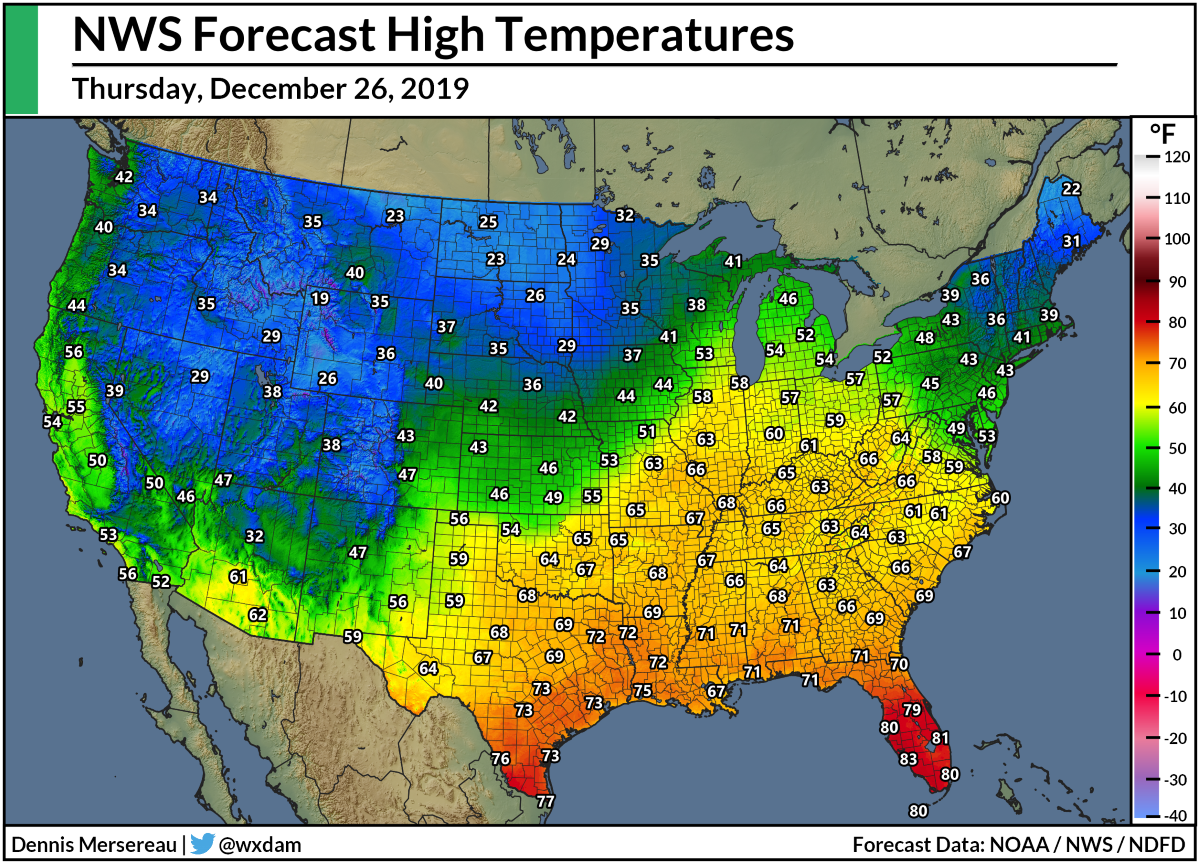
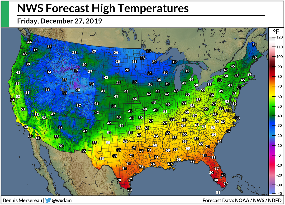
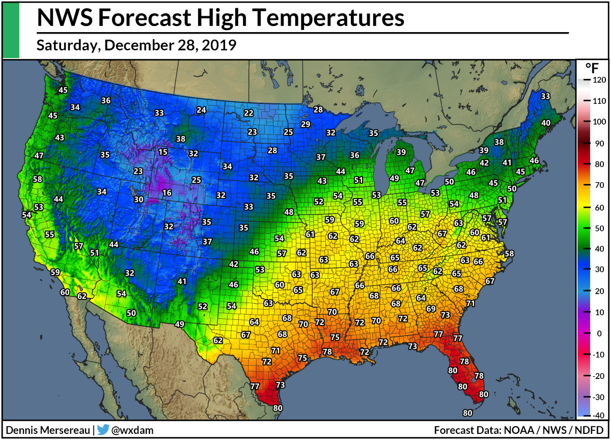
The ridge will slide east through the end of the week, briefly allowing more seasonable temperatures to wash across the Midwest before a ridge redevelops this weekend and pumps 50s and 60s back toward the Great Lakes. It’s likely that above-average temperatures will continue across parts of the eastern U.S. through next week.
Here’s a look at the National Weather Service’s forecast high temperatures through Sunday.
Thursday, Dec. 26
Friday, Dec. 27
Saturday, Dec. 28
Sunday, Dec. 29
[Top Image: Tropical Tidbits]
Please consider subscribing to my Patreon. Your support helps me write engaging, hype-free weather coverage—no fretting over ad revenue, no chasing viral clicks. Just the weather.

