

Atlantic Canada will have a rough time of it over the next couple of days as Hurricane Teddy transitions into a powerful nor’easter-type storm and roars across the region. Intense winds, heavy rain, and coastal flooding could batter Nova Scotia, New Brunswick, Prince Edward Island, and eventually Newfoundland over the next couple of days.
Hurricane Teddy made an uncomfortably close pass to Bermuda on Monday, just a week after the eye of Hurricane Paulette made a direct hit on the tiny island in the western Atlantic. Teddy only brushed the island with gusty winds and heavy rain. The hurricane is picking up speed as it races toward Atlantic Canada, where it should make landfall in Nova Scotia on Wednesday.
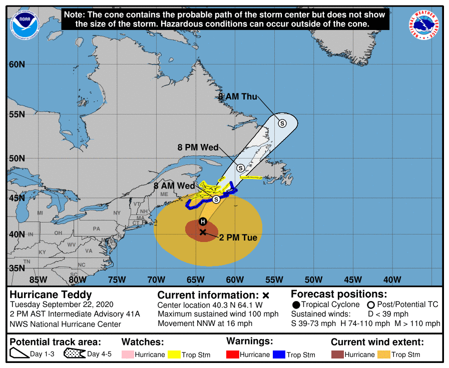 |
| Source: National Hurricane Center |
Hurricane Teddy is undergoing a process known as “extratropical transition” as it approaches the region. I’ll get more into that a little farther down in the post, but that has three practical effects for folks in the Maritimes:
➤ The storm is tremendously large now. The hurricane’s wind field measures more than 1,500 kilometers (900+ miles) across now. This huge expansion in the storm’s size will expose more communities to strong winds that could lead to widespread tree damage and power outages. The extent of the tree damage and power outages could take folks here off-guard since trees are still in full leaf and powerful windstorms don’t typically strike this region until the winter.
➤ A dangerous storm surge is likely along the southeast coast of Nova Scotia, flooding from which will be exacerbated by waves that could grow as high as 10 meters (30 feet).
➤ The storm won’t weaken as quickly as tropical cyclones normally would as they enter the colder waters of the northwestern Atlantic, prolonging the storm’s duration and allowing it to affect a larger area at full strength.
If you live in Atlantic Canada, make sure you’re prepared for at least a couple of days without power. Ready-to-eat foods (anything you don’t have to cook) is a must. Bottles or jugs of water are handy if you have well water. Stay aware of tall trees or heavy limbs that might be near your home, avoiding those parts of the house during high winds if you can’t take care of them before the storm starts.
Also remain mindful of flooded roads—it doesn’t take much for a vehicle to become stranded in standing water, and it takes even less effort for moving water to lift a vehicle and sweep it off the road.
Extratropical Transition
 |
| Hurricane Teddy transitioning from a tropical cyclone to an extratropical cyclone between September 20 and September 22. Source: College of DuPage |
Teddy has mostly completed its transition from a tropical cyclone to an extratropical cyclone.
Tropical cyclones feature warm, muggy air across the whole storm. It’s sticky, windy, and rainy on all sides of the storm. An extratropical cyclone is your common low-pressure system that feature frontal boundaries. Extratropical cyclones feature cool, dry air and warm, muggy air rotating around the storm, bringing a diverse array of weather as they pass through a region.
One of the biggest differences between the two types of low-pressure systems is how they derive their energy, and that’s what makes this transition so important when a storm is closing in on landfall.
 |
| A history of Hurricane Teddy’s wind field over the last couple of days. |
A tropical cyclone is powered by strong, persistent thunderstorms around its center of circulation. The updrafts in these thunderstorms suck air away from the surface, leaving lower air pressure at the surface. This low-pressure center supports those persistent thunderstorms and creates a feedback cycle that allows the storm to strengthen. The storm’s energy is condensed around the center of the storm, leading to a compact wind field that usually limits the extent of the strongest winds.
An extratropical cyclone, on the other hand, is powered by strong upper-level winds spreading out as they round troughs and jet streaks (pockets of stronger winds) within the jet stream. This divergence leaves a void in the upper-levels of the atmosphere that air from the surface has to rush upward to fill, creating low pressure at the surface.
Since extratropical cyclones have a much larger and more diffuse source of energy, storms that undergo extratropical transition typically grow in size, affecting a much larger area with strong winds than they would have if they’d remained tropical cyclones. You can see the difference in the size of Teddy’s wind field in the National Hurricane Center’s wind analysis above. It’s more than doubled in size since this weekend.
Tropical storms and hurricanes that survive their trek through the Atlantic Ocean often transition from tropical cyclones to extratropical cyclones as they race toward the northern latitudes. This is usually a run-of-the-mill process that happens far away from land, but it can be pretty dramatic if it’s already a strong storm and the transition happens close to land.
The most famous (and probably the most extreme!) example of this process was 2012’s Hurricane Sandy. The hurricane completed its extratropical transition right at landfall, which is why it had such an enormous and destructive footprint. Teddy isn’t Sandy, but it’s going to be a dangerous and memorable storm for Atlantic Canada.
[Satellite Image: NOAA]
You can follow me on Twitter or send me an email.
Please consider subscribing to my Patreon. Your support helps me write engaging, hype-free weather coverage—no fretting over ad revenue, no chasing viral clicks. Just the weather.