Tropical Storm To Develop In Gulf On Saturday—One Of Six Atlantic Systems To Watch
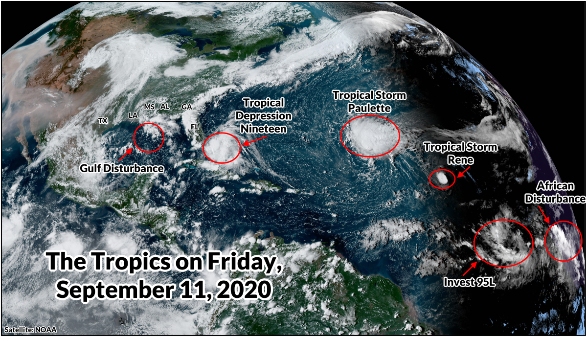
The National Hurricane Center‘s tropical outlook map is lit up like the dashboard on a rickety old car. Forecasters are tracking six different features in the Atlantic Ocean: two named storms, a soon-to-be named storm, and three disturbances that could develop soon. The greatest risks to land right now are a tropical depression over The Bahamas and Tropical Storm Paulette, which could hit Bermuda as a hurricane early next week.
This week marks the climatological peak of hurricane season. This is the point when atmospheric conditions and sea surface temperatures are usually most favorable for tropical activity in the Atlantic Ocean, and it’s certainly proving true this year.
Tropical Depression Nineteen

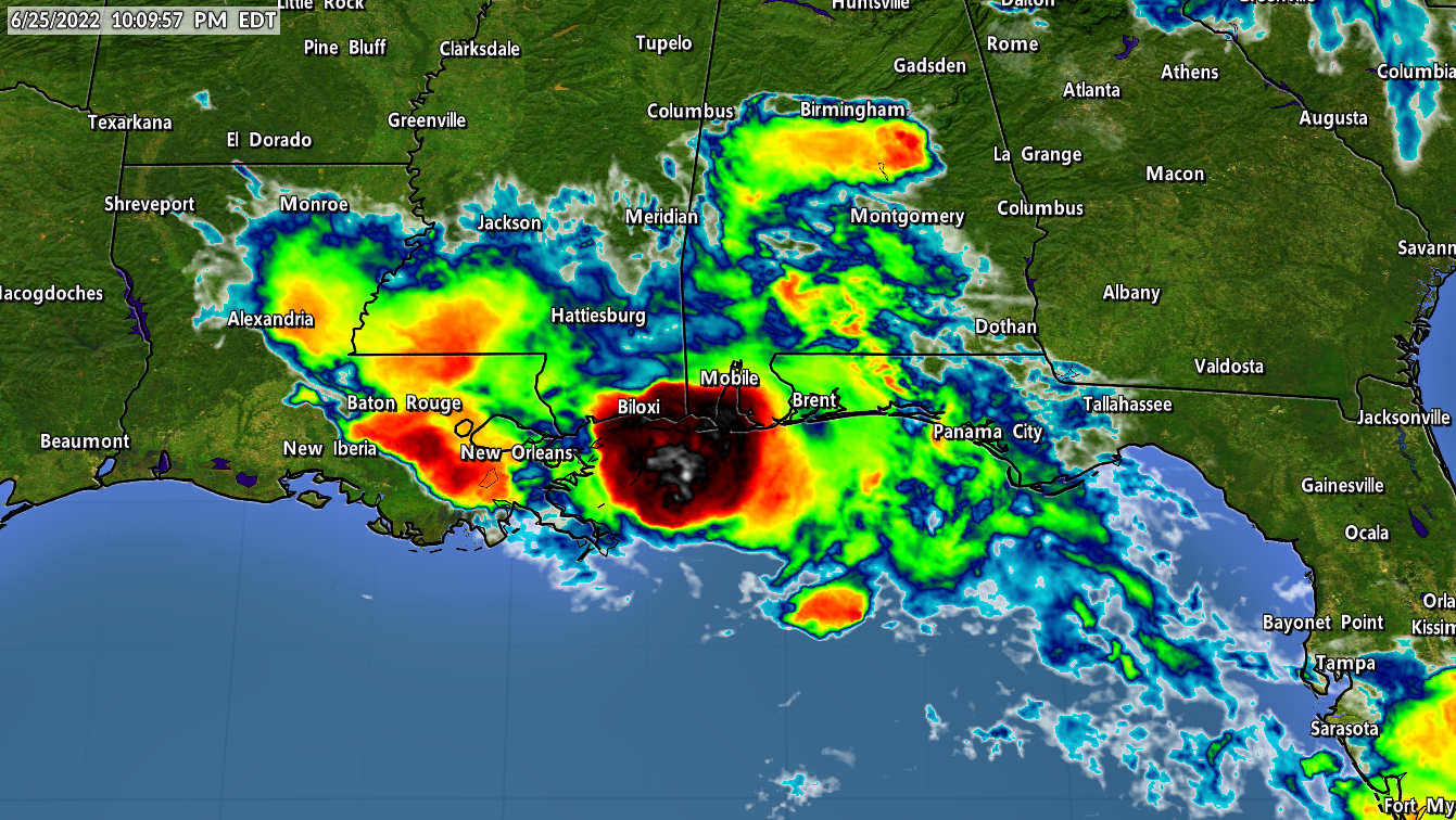
A disturbance we’ve been watching for a few days organized into Tropical Depression Nineteen over The Bahamas on Friday afternoon. The system will likely strengthen into Tropical Storm Sally within the next day or so as it moves across southern Florida and heads into the eastern Gulf of Mexico.
A tropical storm watch is in effect for southeastern Florida ahead of the depression’s landfall tonight, and it’s likely that more watches and warnings will be needed for the Gulf Coast later this weekend.
The Gulf is plenty warm enough to sustain a storm. It’s been a few weeks since Marco and Laura and those storms didn’t do much to cool down the water anyway. Atmospheric conditions should be favorable for further development if the depression can root itself in the environment and organize as it heads toward land.
The NHC’s forecast shows the system nearing hurricane strength when it reaches the northern Gulf Coast on Monday and Tuesday.

Regardless of its strength, the system looks like it’ll bring some heavy rain to the Gulf Coast. The Weather Prediction Center’s precipitation forecast issued on Friday afternoon shows the potential for 5″+ of rain along the northern Gulf Coast, with higher totals likely if the storm organizes and strengthens.
Folks from New Orleans to Tampa need to watch this system closely and get ready to take action early next week as it closes in on the area. Make sure you’ve got a plan if you live in a flood-prone area. Check your supplies and make sure you’ve got enough food, water, and batteries to make it through a couple of days without power.
Tropical Storm Paulette

Paulette’s still out there. The storm formed way out in the eastern Atlantic last Sunday and it’s spent the week chugging along a west-northwestward track across the Atlantic Ocean.
The NHC’s latest advisory calls for Paulette to strengthen into a hurricane as it heads toward Bermuda this weekend. A cold front sweeping off the U.S. East Coast will meet the hurricane in the western Atlantic on Monday, forcing the storm to stop in its track and abruptly curve northeast.
The timing of when the hurricane meets the cold front will make all the difference for Bermuda. There’s a chance that the storm pivots and makes a direct landfall in Bermuda, which would expose the island to a period of intense winds and storm surge. If the turn happens sooner or later, the island would feel fewer impacts from the storm.
Tropical Storm Rene
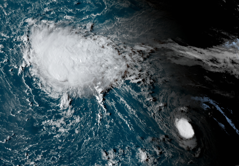
Rene formed just a little while after Paulette. The system moved through the Cabo Verde Islands as a tropical storm earlier this week, bringing bad weather to an island chain that usually escapes the direct impacts of a strengthening storm. (Systems that originate in Africa usually don’t organize until they’re well west of the Cabo Verde Islands.)
The tropical storm has been clinging to existence since it developed, and it’ll continue maintaining itself through the weekend. It’s not much bigger than your average thunderstorm over land. The size comparison above shows Paulette (top-left) and Rene (bottom-right).
Rene will stay out in the middle of the Atlantic and it shouldn’t pose any threat to land.
Invest 95L
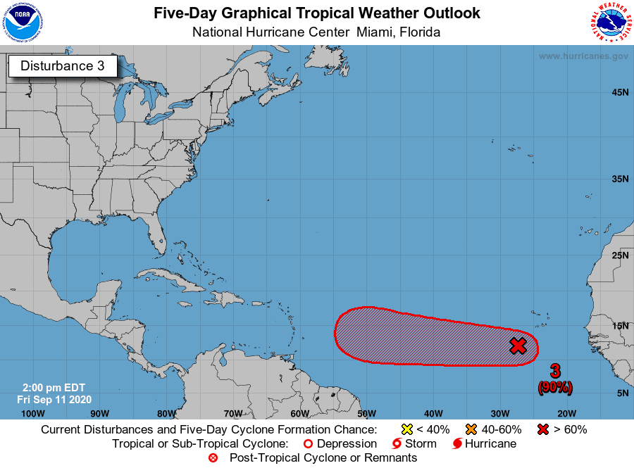 |
| Source: NHC |
The next best chance of a named storm out in the Atlantic Ocean is a disturbance that rolled off the western coast of Africa a couple of days ago. Invest 95L, as it’s dubbed for tracking purposes, is a broad area of disorganized showers and thunderstorms that’s far out in the eastern Atlantic. Conditions are favorable for the system to coalesce and develop into a tropical depression or a tropical storm this weekend.
The system is far enough south that it’s something we need to watch for potential issues in the Caribbean next week. It’s far too early to talk about what it could mean for the United States—it’s still more than a week and a half away from the U.S., which is plenty of time to watch and wait.
African Disturbance
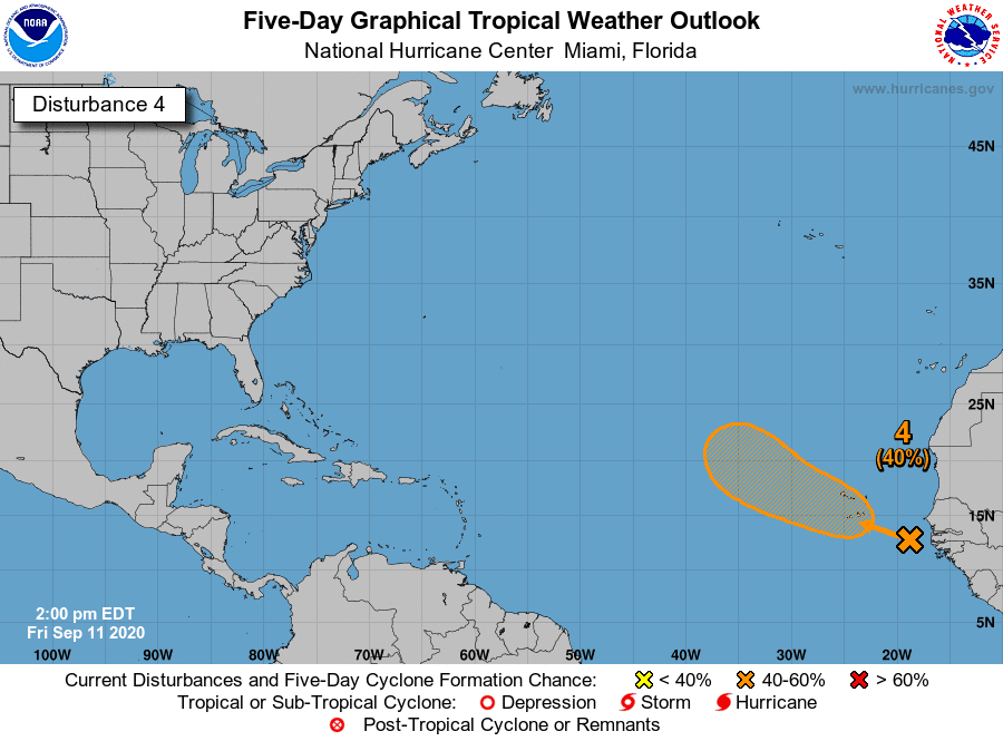 |
| Source: NHC |
Another disturbance coming off the western coast of Africa had a 40 percent chance of development in the NHC’s latest outlook. This system will bring some foul weather to the Cabo Verde Islands as it moves west-northwest this weekend. It’s on a path that’ll probably take it into the central Atlantic and away from land.
Gulf Disturbance
There’s a disorganized cluster of thunderstorms south of Mobile that the NHC has pegged for a 30 percent of development as it moves west through the Gulf of Mexico.
The system only has a low chance of development right now, but with warm waters, low shear, and plenty of moisture to work with, there’s always the chance that it could get its act together as it moves into the western Gulf. The disturbance could bring an inch or two of rain to coastal Texas regardless of its development.
Greek Watch ’20
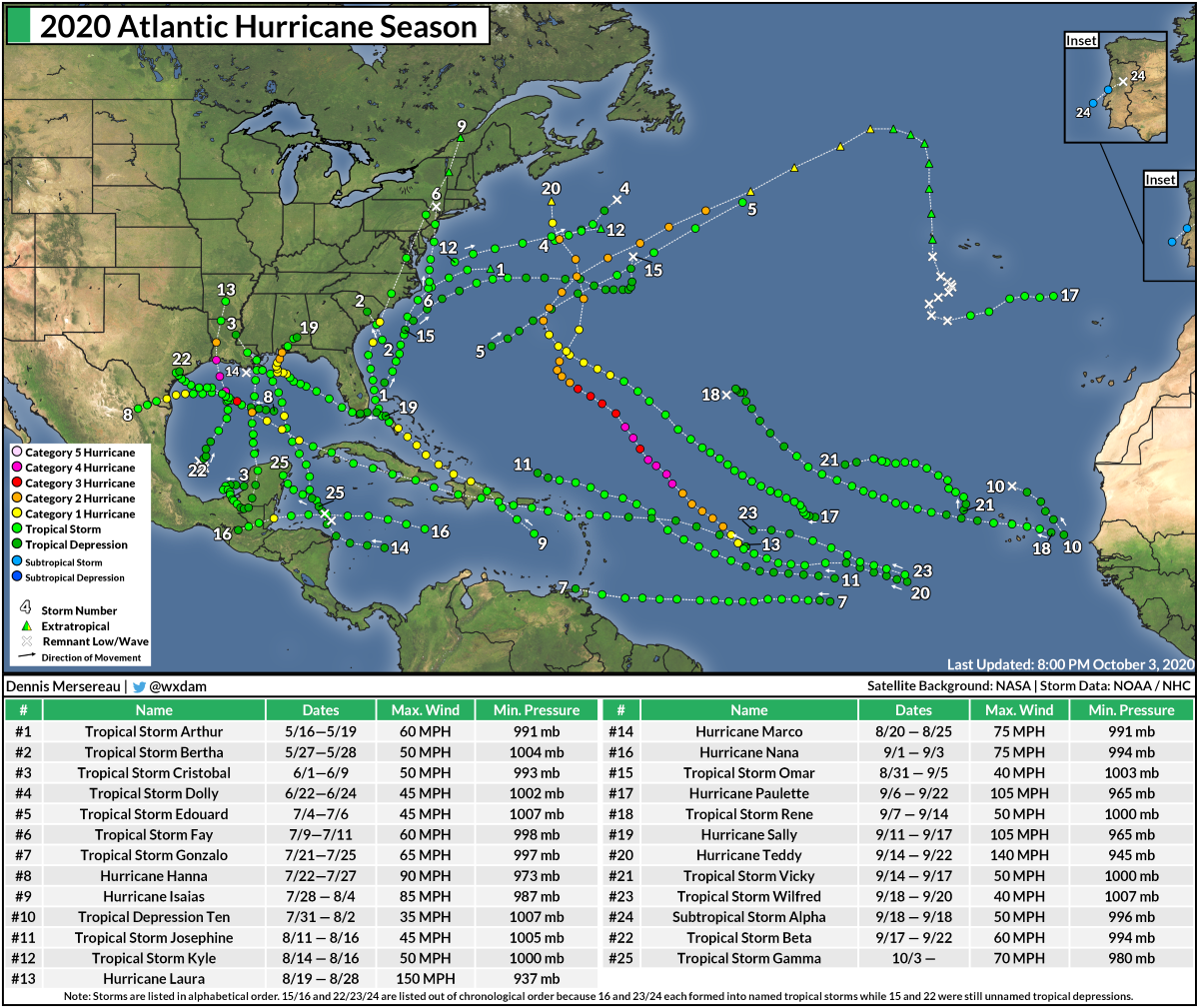
The countdown to running out of names in the Atlantic forges ahead. We’ve already had 17 named storms this year and there are just four names left on this season’s list of names: Sally, Teddy, Vicky, and Wilfred.
The NHC starts naming storms using the Greek alphabet if a season exhausts its official list of 21 names. It’s worth pointing out that 11 of the 18 named storms that formed last year formed on or after September 12.
Barring some freakish and unforeseen shutdown of the atmosphere over the Atlantic Ocean, it’s almost certain that we’ll dive into Greek letters this year for just the second time on record. The only season to exhaust its list of names was 2005, which required the use of six Greek letters to name the season’s final handful of storms.
Any named storms after Wilfred that will come from the Greek alphabet. The Greek alphabet goes: Alpha, Beta, Gamma, Delta, Epsilon, Zeta, Eta, Theta, Iota, Kappa, Lambda, Mu, Nu, Xi, Omicron, Pi, Rho, Sigma, Tau, Upsilon, Phi, Chi, Psi, and Omega. We made it up to Zeta by the end of December 2005.
[Satellite Images: NOAA]
You can follow me on Twitter or send me an email.
Please consider subscribing to my Patreon. Your support helps me write engaging, hype-free weather coverage—no fretting over ad revenue, no chasing viral clicks. Just the weather.

