Oh No. Oh No. Here Comes The Snow.

A decent nor’easter will sweep across the Mid-Atlantic and Northeast over the next couple of days, bringing heavy snow to folks from western North Carolina through Atlantic Canada. This could be the biggest snowstorm to affect the Washington D.C. area in two years. The storm will unfold in two parts, the first affecting the Mid-Atlantic on Sunday and Monday, with the stronger storm—and highest snow totals—sweeping across coastal communities of the Northeast on Monday and Tuesday.
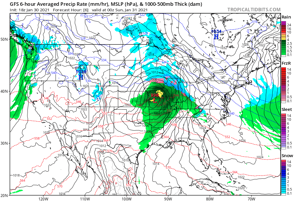 |
| Source: Tropical Tidbits |
This bout of snow and ice is really two different storms creating one big mess. You can see the evolution of the two storms using the model image above, from Tropical Tidbits, which shows the GFS model’s guidance from Saturday night through Tuesday evening.
The first low-pressure system moved across the Midwest and Ohio Valley on Saturday, bringing heavy snow to Wisconsin, Illinois, and Indiana. Some lucky folks (or unlucky folks, depending on your level of Winter Hatred) will see more than half a foot of snow by the time the precipitation ends. This system will slide into the Mid-Atlantic overnight Saturday into Sunday and produce ice over parts of North Carolina and southern Virginia while laying down a blanket of snow in the D.C. and Baltimore areas.
A pre-event band of snow already moved through N.C. and Virginia on Saturday evening, dropping a quick dusting to inch of snow across the affected areas before the main storm moves in later on. I took the pic at the top of the post just before publishing this. I stopped writing to go outside and sample the quality and purity of the snow. You know…for science.
That first storm will start to wind down as the upper-level trough sharpens over the East Coast. The resulting classic trough will generate a classic nor’easter off the coast of New Jersey. Snow will crank in earnest beginning on Monday morning as the low develops and takes over. Fairly heavy snow rates, possibly a few inches an hour, are likely across parts of eastern Pennsylvania, New Jersey, NYC, and Long Island as the nor’easter deepens. Snow will taper off on Monday night and Tuesday from south to north as the storm moves off toward Atlantic Canada.
Here’s National Weather Service’s snowfall forecast from Saturday evening through Tuesday evening, including snow from the first storm to the west and most of the subsequent storm back east:

There’s pretty good agreement between the offices that the greatest snowfall totals will occur during the peak of the nor’easter. Someone will wind up getting a foot or more by the end of the storm. As always, tiny changes in the track of the storm could result in big differences in the final accumulations. If the storm moves a bit west or east, the axis of heavy snow will follow suit.
Ice will be a problem farther south. Winter storm warnings are in effect for freezing rain in southern Virginia and parts of the North Carolina Piedmont (which is where I live). It’ll be cold enough at the surface for snow, but an intrusion of warm air a few thousand feet above the surface will force snowflakes to melt into liquid raindrops. These raindrops will fall into that subfreezing air at the surface and freeze on contact with exposed surfaces. Some areas could see as much as one-quarter of an inch of ice accretion, which could lead to tree damage and power outages.
You can follow me on Twitter or send me an email.
Please consider subscribing to my Patreon. Your support helps me write engaging, hype-free weather coverage—no fretting over ad revenue, no chasing viral clicks. Just the weather.

