A High-Risk Tornado Outbreak Is Likely In The Southeast On Thursday

A severe weather outbreak is likely across the southeastern United States on Thursday as a powerful low-pressure system moves through the region. This is another rare “high risk” day for the southeast, covering many of the same areas as last week. Forecasters at the Storm Prediction Center don’t issue high risks lightly, signaling their confidence in the potential for a tornado outbreak (in their own words) as well as widespread damaging wind gusts and hail the size of golf balls or larger.

A high risk is a full 5 out of 5 on the categorical scale measuring the threat for severe weather. The scale-topping risk area covers a big swath of the southeastern United States. The high risk covers northeastern Mississippi, northwestern Alabama, and a portion of southern Tennessee, including the communities of Florence and Decatur in Alabama and Tupelo and Columbus in Mississippi.
A moderate risk, which is still a significant 4 out of 5 on the categorical scale, covers a much wider area that includes northern Mississippi, northern Alabama, and most of western and central Tennessee. This moderate risk includes the cities of Tuscaloosa, Birmingham, and Huntsville in Alabama; Columbus, Starkville, and Jackson in Mississippi; and Nashville, Memphis, and Jackson in Tennessee.
Strong to severe thunderstorms are possible outside of the bullseye, so to speak, with folks from Galveston to Cleveland at risk of seeing some severe thunderstorms on Thursday.
Don’t just focus on the high risk area. There’s a threat for significant, long-lived tornadoes in and around the enhanced risk (orange), moderate risk (red), and high risk (magenta) areas. The categories only convey the confidence in storms and coverage of storms expected in that particular region. You’re not out of the woods if the red or magenta shading on the map is a few dozen miles away from where you live. In fact, it means you need to pay closer attention specifically because the greatest threat is so close to you.
Scale-topping high risk days are rare because it’s the closest tool meteorologists have to sounding the alarm for a dangerous severe weather outbreak. High risks are reserved for setups that could produce significant tornado outbreaks or extensive wind damage from derechos. Environmental conditions appear favorable for strong, long-lived tornadoes with this outbreak. The experts at the Storm Prediction Center are trying to focus residents’ full attention toward the sky on Thursday.
The Threat

The impending severe weather threat comes to us courtesy of a strong low-pressure system over the southern Plains that’ll move toward the Midwest during the day on Thursday. Strong southerly winds to the south and east of the low will drag plenty of unstable air over the southeastern states. Powerful wind shear through the atmosphere will allow thunderstorms to develop rotating updrafts, turning into supercells capable of supporting strong tornadoes, damaging winds, and large hail. Forecasters expect the tornado threat—the greatest combination of instability and wind shear—to peak across the moderate and high risk areas late in the afternoon and evening hours on Thursday.
The map above shows the Storm Prediction Center’s tornado probability forecast for Thursday. The graphic shows the potential for at least one tornado within 25 miles of any point within the shaded areas. Remember that we’re talking about tornadoes and not rain showers here—a 5 percent risk is enough to warrant concern, so it’s pretty darn serious when you get up to 15 percent and 30 percent. The black hatching covers the areas where supercells could support strong, long-track tornadoes.
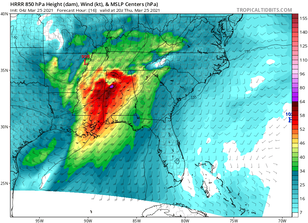 |
| A weather model graphic showing intense low-level winds, providing the wind shear thunderstorms will need to spin and potentially produce tornadoes. SOURCE: Tropical Tidbits |
Severe thunderstorms will likely begin across the southern end of the risk areas during the late morning or early afternoon hours on Thursday, spreading northward across the region through the afternoon. It’s important to pay attention through the whole day and not to assume that the threat is over after one round of ugly storms moves through.
Caveats
No two severe weather outbreaks are ever alike. There’s a strong urge to compare big severe weather days in the southeast to April 27, 2011, the benchmark day that saw hundreds of deadly tornadoes across more than a dozen states. It’s really hard for all the ingredients to come together to create a historic day like that. It’s not all that hard, on the other hand, for a single tornado to cause a significant amount of harm and destruction.
Last week’s tornado outbreak lacked the photogenic, monstrous tornadoes that they make documentaries about on cable television. The lack of big tornadoes doesn’t mean that the outbreak was a “bust.” In fact, the state of Alabama recorded 25 tornadoes from the March 17th severe weather event, making it the state’s sixth-most prolific tornado outbreak on record. Only five other tornado outbreaks on record saw more tornadoes touch down than what happened last week. It was a stroke of luck and a messaging success that there were no major injuries or deaths.
There are plenty of modes of failure for a bigtime severe weather outbreak. Those rare and memorable events are rare and memorable for a reason. Early-morning rain and storms could limit instability available for more storms later on in the day. Sloppy storm modes—storms forming as clusters or lines instead of individual supercells—could limit the tornado threat. Lots of storms forming in the same area could interfere with one another, preventing any one storm from taking root and living up to its full potential.
But we can’t count on any of that happening. The environment is primed for significant, long-track tornadoes across Mississippi, Alabama, and Tennessee on Thursday. That’s what residents should prepare for. It’s trite, but it really does “only take one.” Even if the whole day is just a rainy slopfest, one storm could break out and create a huge mess.
Safety
(I shamelessly copied and pasted this section from my post last week. Don’t tell anyone.)
The best way to prepare for severe weather is to have a way to receive warnings the moment they’re issued. No matter where you live, even if you’re reading this from some chilly town up in New England, take a second to check your phone and make sure that emergency alerts are activated for tornado warnings.
These are push notifications that pop up and screech at you if you’re within a tornado warning issued by the National Weather Service. They only pop up if your location (really, the nearest cell phone tower’s location) is within the warning polygon drawn on a map by an NWS forecaster. This means won’t get notified for storms on the other side of the county unless they’re headed your way in the next few minutes.
Remember that the goal of tornado safety is to protect yourself from flying debris. That’s why they urge you to get to the lowest floor and in an interior room, putting as many walls between you and the outside as possible. It doesn’t stop there, though. Wear a helmet if you have one. Even a simple bicycle helmet can help protect your head from flying debris. Also, wear jeans and closed-toe shoes in case you have to walk through debris. I’ve slept in my jeans and socks before in case I had to jump out of bed for a tornado warning. It’s uncomfortable, but it’s worth it.
(1140AM: Corrected the fourth-to-last paragraph where I mistakenly said “Wednesday” instead of “Thursday.” Sorry about that.)
You can follow me on Twitter or send me an email.
Please consider subscribing to my Patreon. Your support helps me write engaging, hype-free weather coverage—no fretting over ad revenue, no chasing viral clicks. Just the weather.

