Severe Weather Outbreak Likely Across The Deep South On Wednesday
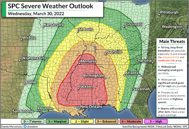
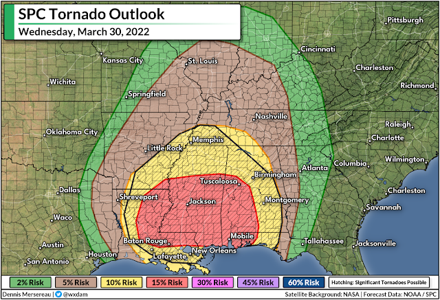
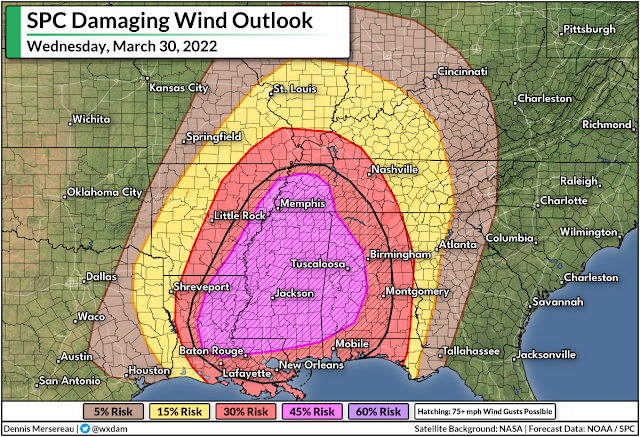
A “regional outbreak of severe thunderstorms” is likely across the Deep South on Wednesday, according to the Storm Prediction Center. A large swath of the region is under a moderate risk for severe thunderstorms, including Memphis, Jackson, Mobile, Baton Rouge, and Tuscaloosa. The greatest threats are widespread significant wind gusts of 75+ mph and the potential for strong, long-lived tornadoes.
This could be a high-impact severe weather event for the area. We’re looking at a classic springtime severe weather setup. A low-pressure system heading toward the Great Lakes will allow warm, unstable air to soar north from the Gulf of Mexico. Severe thunderstorms will bubble along and ahead of the low’s trailing cold front, sparking several opportunities for dangerous storms across the region.
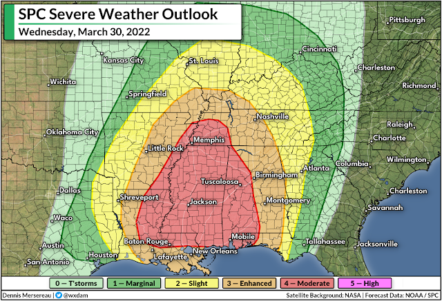
The Storm Prediction Center included a large area under a moderate risk for severe weather, which is the second-highest category on the agency’s scale measuring the threat for severe storms.
This moderate risk is in effect due to the potential for widespread significant wind gusts of 75+ mph and an environment capable of supporting strong, long-lived tornadoes. The risk for destructive wind gusts and significant tornadoes extends into the enhanced risk area, which includes an even larger portion of the Deep South.
A powerful line of severe thunderstorms will develop over the southern Plains late Tuesday night through early Wednesday morning. The storms will continue into Arkansas and Louisiana through Wednesday morning, heading toward the Lower Mississippi River Valley by Wednesday afternoon.
We’ll have two distinct severe weather threats on Wednesday afternoon and evening: individual thunderstorms ahead of the line that could grow into tornadic supercells, and the line itself along the cold front. These storms will push into Alabama on Wednesday evening and continue east through the nighttime hours.
Widespread severe weather is dangerous, but the timing and speed of the storms will heighten the risk to folks in the region. Some storms will occur after dark. Many of the storms will be moving at highway speeds.
Please make sure you have a way to get severe weather warnings the moment they’re issued. Check your phone to ensure that emergency alerts are activated for tornado warnings. When a warning is issued, take action—don’t wait to see danger before you seek shelter.
Powerful straight-line wind gusts can cause as much damage as a tornado. Take stock of any trees or tree limbs that could fall on your home and avoid those rooms when thunderstorms are imminent. Also, make sure you have the supplies necessary to deal with a period without electricity. This is the kind of setup that could lead to widespread and potentially long-lasting power outages.
You can follow me on Twitter or send me an email.
My new book, The Skies Above, comes out on Friday, April 1st! Grab your copy today and learn about the wonders of our atmosphere and beyond.

