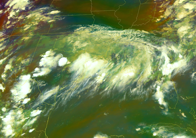
The southern half of the United States finally dove into a wet pattern after so many weeks (and weeks, and weeks...) of hot and dry conditions. We're feeling tropical moisture associated with a disturbance that almost became a tropical storm in the Gulf. Some areas are still in line for more than half a foot of rain through early week, which will lead to flash flooding in spots.
Even though it's been a quiet hurricane season so far this year, the current pattern is a setup we're familiar with around the middle of the summer.
Tropical moisture pumping north serves up a deep reservoir of atmospheric moisture for thunderstorms to tap into and drench whoever gets caught under them. A stationary front parked over the Mid-South provides the trigger to set off these storms for days at a time.
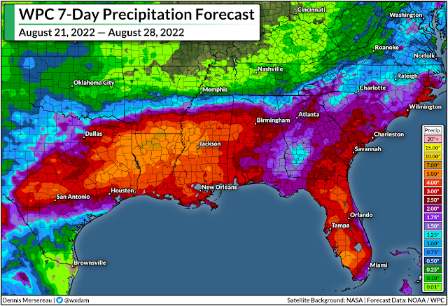
As a result, the latest 7-day rainfall forecast from the Weather Prediction Center (WPC) calls for the potential for 5-8 inches of rain from northeastern Texas through central Mississippi, with the heaviest rains possible over northern Louisiana. Not everyone will see that much rain, of course, but the forecast illustrates the potential for flooding rains wherever those storms happen to set up shop.
Widespread flash flood watches are in effect for the affected areas over the next couple of days.
Flash flooding is one of the deadliest weather hazards in the United States. It's impossible to tell how deep the water is until it's too late, and it only takes a couple of inches of moving water to pick up a vehicle and carry it downstream.
If you live here or you're visiting, make sure you know your way around and plan out alternate routes to get where you need to go in case you come across a road closed due to flooding.
It's been a while since some of these areas have had to deal with a flooding threat. It's been a hot and dry summer across much of the country, and this part of the south is no exception.
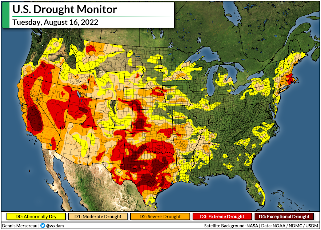
Last week's update of the United States Drought Monitor (USDM) painted widespread drought conditions across the areas seeing these tropical downpours. The long stretch of arid weather has hit northern Texas particularly hard, with extreme to exceptional drought—the two highest categories—stretching into the Dallas area.
While we're likely to see some great improvements in next week's USDM update, this much rain falling this quickly doesn't help as much as a slower, steadier rain would. Gushing downpours tend to run off before they can fully soak into the ground, leading to flash floods for communities that are just looking to catch a break.
[Top Image: NOAA]
You can follow me on Twitter or send me an email.
Please consider subscribing to my Patreon. Your support helps me write engaging, hype-free weather coverage—no fretting over ad revenue, no chasing viral clicks. Just the weather.
Please consider subscribing to my Patreon. Your support helps me write engaging, hype-free weather coverage—no fretting over ad revenue, no chasing viral clicks. Just the weather.


0 comments: