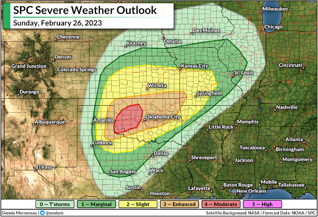
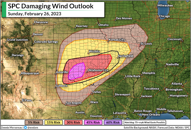
This year's first big threat for severe weather will target Oklahoma this weekend as forecasters expect a dangerous squall line to sweep across much of the state on Sunday.
A robust low-pressure system will develop over the central Plains this weekend as a trough crests the Rockies. This is the same trough responsible for all that wild snow in California—that's a lot of energy heading east.
Plenty of warm, humid air bathed over the southern Plains will provide ample fuel for vigorous thunderstorms to develop along and ahead of this low-pressure system's cold front through the day Sunday.
There's enough wind shear that forecasters with the Storm Prediction Center expect a powerful line of thunderstorms to develop along the front. They've issued a moderate risk—a 4 out of 5 on the scale measuring the threat for severe weather—for a chunk of western Oklahoma, with an enhanced risk extending east to cover the rest of the state into southwestern Missouri.
This is the highest risk issued by the SPC since December, and it's especially noteworthy because it's for Day 2—they usually wait until the day of the event to upgrade to a high-end risk, a move that conveys their confidence in widespread severe storms on Sunday.
Damaging winds in excess of 75 mph are the main threat with the storms on Sunday, covering the Oklahoma City and Tulsa metro areas, as well as Joplin and Springfield in southwestern Missouri.
Widespread severe wind gusts can cause tree damage and power outages. Folks are often taken by surprise by the strength of severe squall lines, swearing that they witnessed a tornado or "inland hurricane" instead of a line of bad storms.
In addition to the risk for widespread damaging winds, we could see tornadoes develop within the squall line and in any discrete thunderstorms that bubble up ahead of it. Tornadoes embedded in squalls can happen very quickly, sometimes reducing tornado warning lead time down to a few minutes at best.
Folks on the Plains are well versed in tornado safety, but given that it's February and these tornadoes could happen quickly, it's worth taking a few minutes to prepare.
Make sure you (or anyone you know in the area) has a way to receive warnings and get to safe shelter the moment they're issued. Take a look at your phone's settings and ensure that wireless emergency alerts are turned on and activated for tornado warnings.


0 comments: