Hurricane Florence Set to Bring Intense Flooding and Storm Surge to Carolinas

Don’t let the headlines proclaiming that “Hurricane Florence has weakened” fool you. It’s still an intense storm tonight as it lumbers toward the Carolinas. Florence’s winds have dropped below major hurricane status as the storm struggles against wind shear and turmoil within its own structure. While the winds aren’t as ferocious as they once were, Florence is still a large and dangerous storm. Coastal communities will likely suffer a life-threatening storm surge as sustained winds of 100 MPH or more batter the coast for hours on end. After landfall, many areas even hundreds of miles from the coast will be exposed to the threat for flash flooding from potentially-historic amounts of rain.

Hurricane Florence had 110 MPH winds as of Wednesday’s 11:00 PM EDT advisory. Florence is much more ragged looking tonight than it was on Tuesday. The eye is poorly defined and the eyewall is struggling to stay closed due to westerly wind shear disrupting the storm’s structure. Even so, Florence is expected to remain a strong storm through landfall.
RELATED: You Should Prepare for Hurricane Florence Even Hundreds of Miles Inland
It’s not terribly uncommon for a storm like Florence to see its winds start to weaken at this stage in its life cycle. First of all, it’s hard for scale-topping storms to survive this far outside of the tropics. That’s why it was such an eye-popping prospect that Florence could have been the farthest north such a strong storm has made landfall on record in the United States.
The other reason Florence’s maximum winds were prone to falling is the storm’s natural structure. A tropical cyclone’s winds are generated by the extreme pressure gradient between the core of the storm and the environment around it. Weather is nature trying to balance itself out—the intense winds exist because air is rushing in to fill the void at the center of the storm. This usually leads to a tight core of strong winds in the right-front quadrant of the eyewall.
Sometimes, though, a hurricane can translate its deep air pressure into widening the wind field rather than packing all that energy into a tiny part of the eyewall, and that—along with disruption from wind shear—appears to be what’s happening with Hurricane Florence. The hurricane is using its strength to bulk-up rather than sting one particular area.
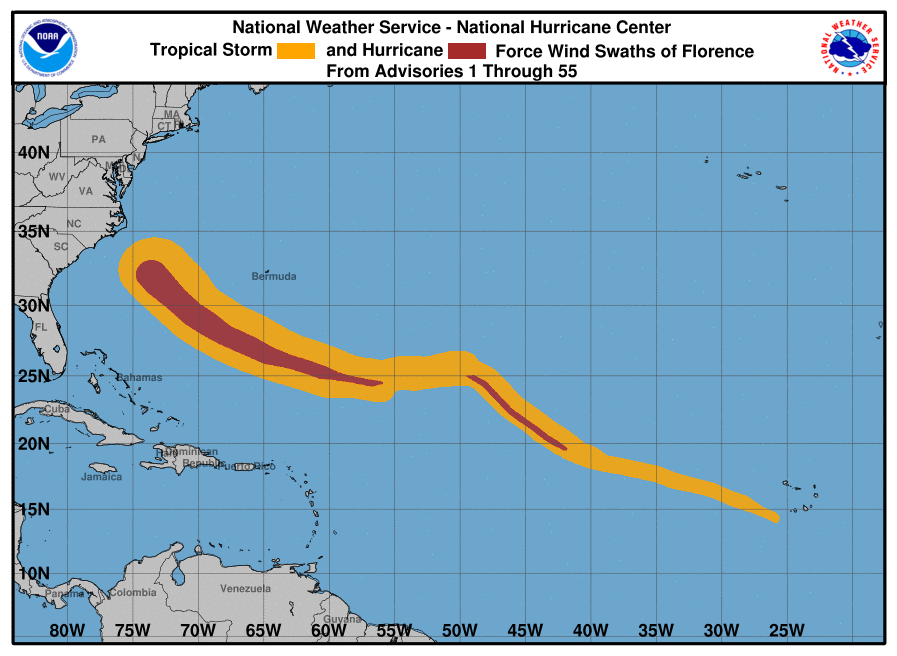
This storm has a very large wind field. The wind swath map above shows how the footprint of Florence’s winds has grown since it strengthened back into a hurricane last week. I hate using this as an example because it may give anyone speed-reading the wrong idea, but the “deep pressure widening the wind field” scenario is one of the reasons Sandy touched such an enormous area of the East Coast. The storm had the minimum pressure of a major hurricane, but only had maximum winds of 80 MPH at landfall—the storm’s wind field at landfall, however, measured about 1,000 miles across. (For comparison, Florence’s wind field measures more than 350 miles across.)
Models seem to have neatly converged on a nightmarish scenario for the southern N.C. and northern S.C. coasts. The storm is now expected slow to a crawl near the coast or just after crossing the shore, subjecting areas to the north of the eye to a prolonged period of destructive winds, storm surge, and potentially-historic amounts of rain. In addition to the damage caused by hours of winds in excess of 100 MPH, the storm surge could exceed nine feet above ground level in the worst-hit areas, completely inundating and likely destroying buildings near the coast.
Once the storm moves inland, meteorologists now expect the center of the storm to dip into South Carolina through the weekend jutting north into the Ohio Valley on Monday. The storm is so large that the exact track of the center of the system only matters in determining who will see the heaviest rain, strongest winds, and the greatest chance for tornadoes through early next week.

The rain will be Florence’s lasting legacy. There’s a chance that some communities are about to have the wettest couple of days they’ve ever recorded. Unprecedented amounts of rain will lead to widespread flooding, even in areas that don’t typically flood. The flooding threat will stretch hundreds of miles inland. Flash flooding is likely near the track of the storm and landslides/mudslides are possible in the mountains as the storm and its remnants move through the area.
This afternoon’s forecast from the Weather Prediction Center showed the chance for more than 20 inches of rain near the coast. Some areas could see more than three feet of rain by the time the storm is over. This could easily be one of the wettest tropical cyclones ever seen in this part of the United States. Rainfall totals of up to a foot are possible inland through parts of North Carolina and South Carolina.
We also can’t ignore the risk for tornadoes. Tornadoes are always a possibility in the right-front quadrant of a landfalling storm—in this case, to the north of the storm’s expected track. Tornadoes that occur in landfalling tropical storms are usually weak and don’t last very long, but they can happen quickly. The tornado warning lead time can be reduced to just a few minutes in a situation like this.
Please consider subscribing to my Patreon. Reader-funded news is more important than ever and your support helps fund engaging, hype-free weather coverage.

