From Guam to Africa, We’re Tracking Seven Different Tropical Systems Right Now
True to form, the tropics are wide awake as reach the much-dreaded peak of hurricane season. The world’s tropical tracking agencies have their hands full with seven systems right now that could all pose a threat to land over the next week or so. The National Hurricane Center‘s map for the Atlantic is lit up like Christmas with five—count ’em, five!—areas of interest, including a storm threatening Hawaii in the eastern Pacific and a significant typhoon approaching Guam in the western Pacific.
The sudden breakneck pace of tropical activity kind of feels like a Billy Joel song.
See? It kinda works.
Tropical Storm Florence

Tropical Storm Florence is still out in the middle of the Atlantic Ocean this afternoon. A shadow of its former self, the once-improbably intense hurricane got knocked down from its former stature by the persistent force of wind shear acting against the storm. The system is essentially in maintenance mode right now as it drifts west through the windy chaos over the Atlantic.
The environment that will determine Florence’s future strength and future track is in question right now. I published an article at Popular Science yesterday detailing the ways in which the environment will determine whether Florence gets pushed out to sea or shunted into the United States. The longer Florence keeps moving west, the greater the odds are that the East Coast will feel some sort of effects from this storm, if not an outright landfall.
We’re still six or seven days away from whatever happens, so you have ample time to prepare if you live along or near the East Coast. It’s a good idea to prepare for hazards like power outages and flooding even if you’re hundreds of miles away from the coast. I keep using this line over and over, but you don’t realize how unprepared you are for a power outage until the lights go out and you’re stuck without dinner or working flashlights.
Invest 94L
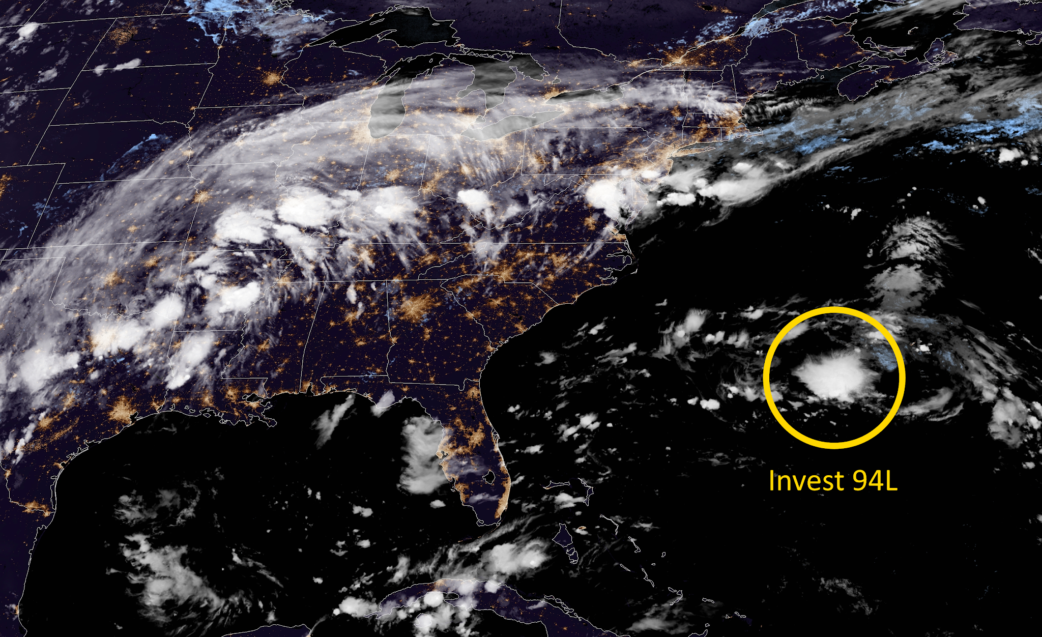
There’s an area of interest a few hundred miles off the coast of North Carolina this evening. Some models completely ignore it and others try to turn it into a named storm. The National Hurricane Center only gives it a 20 percent chance of development. The system is in Florence’s path, so that could be another wrench in trying to predict Florence’s future if the invest turns into a legitimate Thing.
Tropical Depression Eight and Tropical Depression Nine
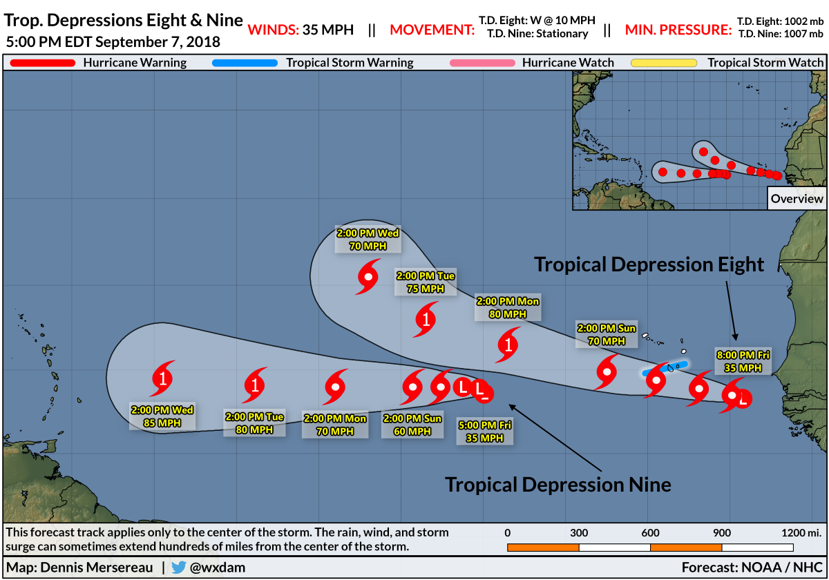
Tropical Depressions Eight and Nine are in a race to see which one becomes Helene and which one becomes Isaac. The two systems are far out in the eastern Atlantic Ocean right now. T.D. Eight just swirled off the African coast, prompting tropical storm warnings for the Cabo Verde Islands. T.D. Nine is stationary as it sits about halfway between Africa and the Leeward Islands.
Tropical Depression Eight will start heading toward the central Atlantic through next week. It shouldn’t be anything we have to worry about in the United States—it’s likely to remain a fish out at sea—but as always, it’s worth close monitoring just in case it starts tracking west.
Tropical Depression Nine could be more of a headache next week as we’re dealing with whatever happens along the East Coast, Hawaii, and Guam. The National Hurricane Center expects Nine to track toward the Caribbean as a hurricane by early next week. The storm will follow a concerning path for this time of year. It’s hard to say what will happen once the system reaches the Caribbean, but it’s safe to say that it’s important to keep your guard up even if Florence won’t affect you. There’s more to worry about behind it.
Hurricane Olivia
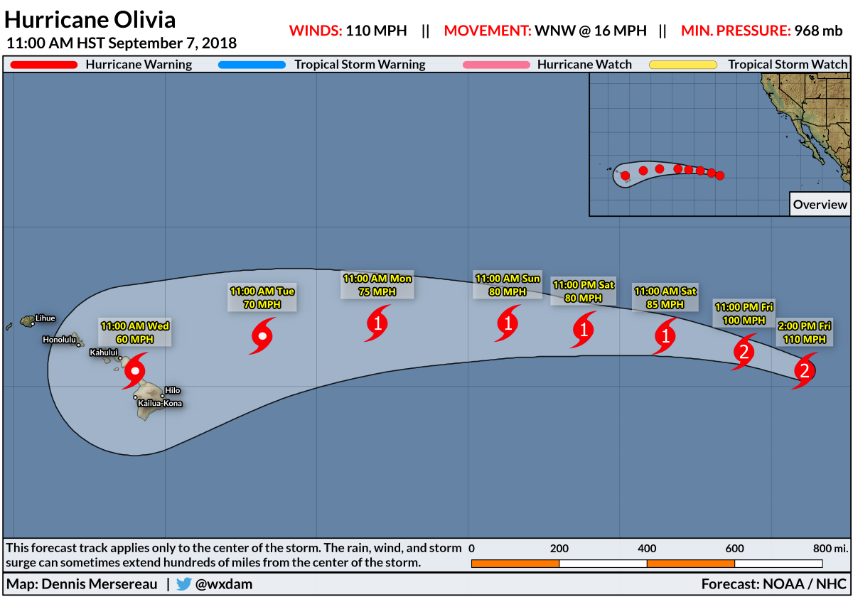
Hawaii has another tropical threat worth watching this evening. This threat comes just two weeks after Hurricane Lane dropped the most rain ever seen from a tropical cyclone in the Hawaiian Islands and second-highest tropical cyclone rainfall total anywhere in the U.S.
The National Hurricane Center currently predicts that Olivia will approach the islands as a tropical storm early next week. The arcing path the storm is expected to take toward the islands is concerning because it might not have much of an “out” for its heavy rain or strong winds to miss the islands. The storm could be a significant flooding and mudslide threat even as it weakens on approach.
Tropical Storm Mangkhut
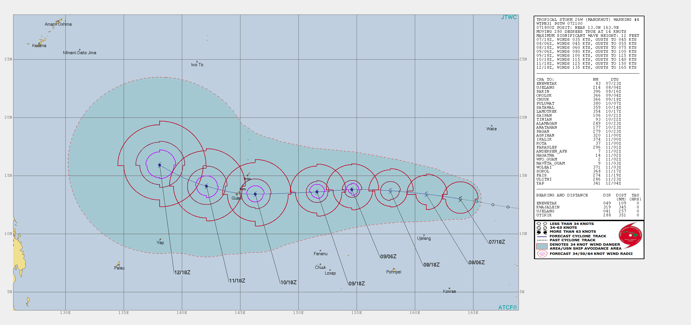 |
| Source: Joint Typhoon Warning Center |
Both Guam and the Northern Mariana Islands, which are territories of the United States and matter very much to us even if we don’t write as often as we should, are also in the path of a developing storm. Tropical Storm Mangkhut could be quite strong when it approaches Guam—current forecasts show it nearing the islands on Monday (local time) as the equivalent of a category four on the Saffir-Simpson Scale with sustained winds around 130 MPH.
The Joint Typhoon Warning Center‘s current forecast takes the worst winds directly over Guam, but Tinian, Rota, and Saipan are very much in the cone of uncertainty. If it approaches the islands as forecast, Mangkhut could be one of the worst storms in these territories in decades.
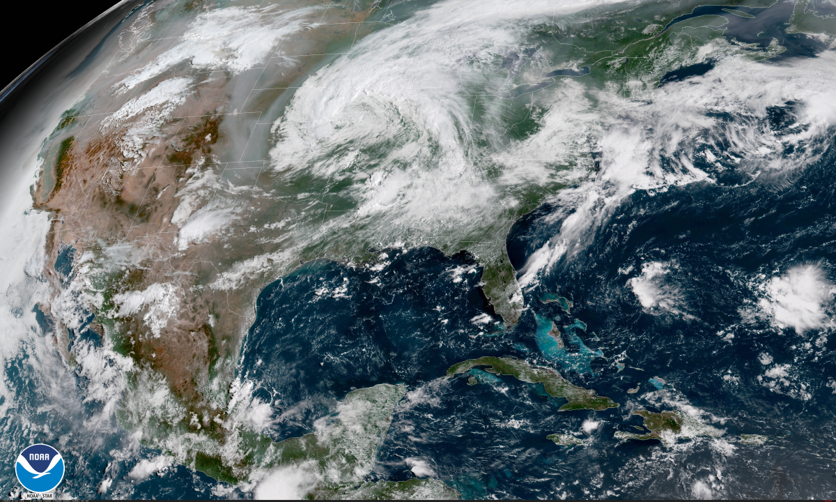
Tropical Depression Gordon
Remember the strong tropical storm that hit Mississippi a hundred and fifty news cycles ago? It’s still clinging to life over central Arkansas as a tropical depression with…10…MPH winds. (No, really!) The system is mostly bringing squally weather to the Mid-South, but flash flooding is possible where storms start training. Even though Gordon made landfall on Tuesday night, it’s not uncommon for tropical cyclones to maintain their tropical characteristics for several days after making landfall, especially when it’s as wet and humid as it has been in the southern part of the country.
Please consider subscribing to my Patreon. Reader-funded news is more important than ever and your support helps fund engaging, hype-free weather coverage.

