Here’s the Scoop on Next Weekend’s Potential Winter Storm
A trough approaching California this week could spread wintry weather from the Rockies to the Atlantic next weekend. It’s too early to know exactly what type of precipitation people will see and exactly how much will fall. Lucky for us, those specifics are all anybody wants to know. Fun fun. Cue up the scary news graphics and melodramatic reporting—it’s (possibly) time for a winter storm!
WHAT WE KNOW
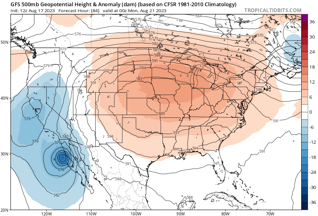 |
| Source: Tropical Tidbits |
A storm looks likely late this week.
For the past week or so, weather models have consistently shown a low-pressure system developing in the southern Plains and sweeping across the Southeast through next weekend. While the timing, extent, location, precipitation types, and amounts—basically everything—are all iffy, it’s pretty likely that a storm will form. That’s the first hurdle.
California is first up to the plate.
The first wave of precipitation will move across California beginning late Tuesday. The latest forecast from the Weather Prediction Center calls for rainfall totals of an inch or two along higher elevations near the coast, while most metro areas will stand to see at least some measurable precipitation. It probably won’t be a lot, but it’s better than nothing.
Track is everything.
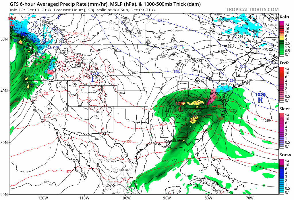 |
| Source: Tropical Tidbits |
The main storm will form once the trough crosses over the Rocky Mountains at the end of the week. The track of the low-pressure system will determine who sees rain, snow, ice, and how much of all three will fall. Snow will be likely along the northern edge of the storm. Folks along and south of the track of the low can expect a chilly rain (and maybe even some thunderstorms).
The low’s track wiggling a few dozen miles to the north or south will mean all the difference for a whole lot of people between Oklahoma and Virginia. This is especially true for the eastern side of the Appalachian Mountains where cold air damming—cold air at the surface getting dammed up against the mountains, forcing warm air to ride above it—frequently wreaks havoc on precipitation types during the winter.
The odd-looking animation above depicts 1:00 PM EST Sunday, December 11, as seen in the last ten runs of the GFS model. This kind of animation is useful for showing trends in successive runs of the weather model. If a GIF could talk, this one would mumble something like “track is everything” and “it’s still too early.” (It would probably also say “it’s pronounced ‘JIF,'” but that’s neither here nor there.)
We (mostly) know the timing.
California Rain: Begins Tuesday and lasts through late Thursday or early Friday.
Plains: Snow/ice begins Friday evening.
Southeast/Mid-Atlantic: Wintry…slop?…begins Saturday evening.
There’s a chance that this could be a long-duration event once the bulk of the storm moves east of the Mississippi River. Winter storms that hit south of the Mason-Dixon line usually come and go in 12-18 hours tops. That might not be the case with this storm, but that could certainly change in the coming days.
WHAT WE DON’T KNOW
We don’t yet know exact snow/ice amounts and who could see what.
Essentially, we don’t know all of the details that people actually want to know. That kind of information will become clearer later this week once we’re closer to the event and weather models have a better handle on the environment leading up to the storm.We know there will be a storm and we know the setup could be conducive for disruptive snow or ice if the storm takes the right track and encounters the right environment. Beyond that, it’s just too darn early to know specifics.
That isn’t stopping The Internet, of course.
The internet-to-reality forecasting cycle is a nasty one. More than a week ahead of a storm, meteorologists and weather enthusiasts will post some scary-looking model images to social media long before they’re useful. These posts go viral. They know they’ll go viral. That’s why they’re posted. We’re not stupid.
Now you’ve got thousands of people who heard that “they” are predicting a big winter storm and “they” are calling for exactly six inches of snow over grandma’s house and three inches of snow over Suzie’s school and so on and so on.
“They,” of course, are the meteorologists who are stuck cleaning up the mess from these viral posts. Forecasters now have to mention the potential for a storm long before it’s certain. That’s why I have to write this daggone post on a Monday night. This post and those forecasts are all dripping with uncertainty. But, no!, that can’t be, because we don’t like uncertainty. We like it when meteorologists talk in specifics because our society at some point decided saying “I don’t know” is code for “I’m a dunce who can’t guess where my mouth is.” That’s why you get maps from weather models on your Facebook feed and forecasts on your smartphone app spitting out snowfall amounts down to the nearest tenth of an inch.
If you’re going to call out snow maps on Twitter, call out the big sites, too…
Meteorologists like to talk smack about people posting “snow maps,” or snowfall accumulation maps generated by weather models like the GFS or the Euro. But you know what annoys me? Checking Wunderground or The Weather Channel’s forecasts ahead of this storm. The forecast changes every time I check the extended forecast.
It’s not just misinterpreted models or misguided meteorologists or no-name weather apps doing people a disservice. When someone who only casually pays attention to weather forecasts opens the app or website of a known-and-trusted company, they’re seeing a definitive forecast for a storm that’s more than five days away.
Take a look at this ridiculousness. I live just north of Greensboro, North Carolina. Here’s what the Wunderground ten-day forecast looked like for my location on Sunday and Monday.


I mean, there are layers of wrongness wrapped up in these forecasts.
First off, it’s way too early to project exact snowfall totals. Look through any meteorologists’ social media feed and you’ll find at least one sermon about forecast accuracy with time and the dangers of pinning specifics when it’s unjustifiable. They know this kind of thing is wrong to do. They do it anyway. That needs to change. (But it won’t.)
What’s even worse is that this kind of jerky lurching between each forecast update isn’t much better than the enthusiasts and meteorologists who post every run of the weather models to their Twitter feeds. Wunderground—and, by extension, The Weather Channel—aren’t the only offenders here. I mean, hell, AccuWeather pretends to know what the low temperature and morning wind speed will be 90 days from now. My mom used to use WeatherBug for her forecasts, so I know that they’re even more aggressive than Wunderground about constantly changing their snowfall totals with each run of the models.
These websites aren’t personal opinion pages where one person is at fault for misleading their tens of fans. These forecasts are going out to tens of millions of people. How many of those consumers know that there are enormous caveats to that forecast of X-Y inches of snow this weekend? How many people, folks who don’t eat and breathe weather forecasts, know that the forecast for Wednesday is much more accurate than the forecast for Sunday and Monday?
We like to direct our ire toward “weather weenies” and careless meteorologists. But the big companies deserve it, too. They’re the ones most people are listening to right now.
Anyway, the most prudent course of action is to follow trends from now until Wednesday night or Thursday, and it’s only then that you should start to pay attention to specific amounts. Anything earlier than that will lead to throbbing headaches, bad plans, and angry Tweets.
Please consider subscribing to my Patreon. Reader-funded news is more important than ever and your support helps fund engaging, hype-free weather coverage.
