A Rare Tornado Touched Down Near Seattle on Tuesday
A strong tornado touched down in Port Orchard, Washington, on Tuesday, damaging several homes and businesses along its path. Meteorologists will conduct storm surveys on Wednesday to assign the tornado an EF-Scale rating, but pictures from local news organizations and social media seem to show that this was a formidable tornado in a part of the country that doesn’t typically see this kind of weather.
Today’s tornado in Port Orchard—which is next to Bremerton and about 30 miles west of Seattle—is a stark reminder that A) tornadoes can happen anywhere in the United States, and B) a significant number of tornadoes in the United States truly occur without warning.
The nasty weather today in the Pacific Northwest is directly tied to the same low-pressure system that generated all of the epic waves that hit the West Coast a couple of days ago. A long fetch across the northeastern Pacific Ocean allowed wave heights to reach 50 feet, posing significant risk to anyone ill-advised enough (to put it nicely) to go swimming or even just wander to the ocean’s edge.
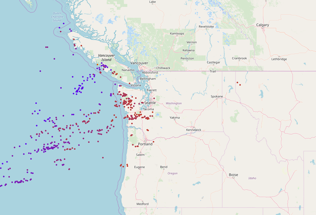 |
| Each dot represents a lightning strike on December 18, 2018. Source: LightningMaps.org |
Bursts of showers and thunderstorms moved across western Washington during the day on Tuesday, producing dozens of lightning strikes along the way. (That’s nothing east of the Rockies, of course, but even one rumble of thunder out west is a talking point for days.) At least one of the thunderstorms was strong enough to tap into enough low-level wind shear to begin rotating.

The thunderstorm that produced today’s tornado had a fairly pronounced signature on it as it crossed the Kitsap Peninsula. The storm’s rotation grew strong enough to produce a short-lived tornado once it reached Port Orchard. Social media lit up as onlookers recorded a funnel that was mostly obscured by heavy rain but clearly present due to the immense amount of debris kicking up into the air. The thunderstorm quickly fell apart after the tornado touched down as more stable air wrapped in and choked off the instability feeding the storm.
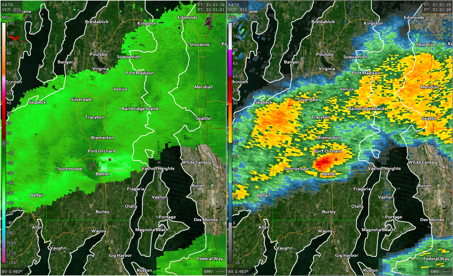
We only had five-minute radar scans of the storms in northwestern Washington today—we’re spoiled by rapid-scan radar imagery these days—but we did get a radar sweep at a critical moment: 1:51 PM PST, during or immediately after the tornado touched down and caused the most damage. That sweep took place at just the right moment to allow us to see debris in the air.
**BREAKING** New video showing a tornado near Port Orchard, WA, Tuesday afternoon just before 2. The @NWSSeattle is working to determine the extent of the damage and will have a storm survey team go out Wednesday morning. #wawx pic.twitter.com/2PRaaWqTCY— WeatherNation (@WeatherNation) December 18, 2018
Dual polarization technology allows us to see the size and shape of the objects showing up on radar. Correlation coefficient (CC) tells us how similar or dissimilar airborne particles are to one another. Raindrops have a high CC value because they’re all pretty much the same size and shape. Tornado debris, on the other hand, has a low CC because you’re seeing everything from branches to vehicles being lofted into the air by the tornado.
Here’s a two-pane radar image from Port Orchard around the time of the tornado. The left pane shows CC values while the right shows precipitation.
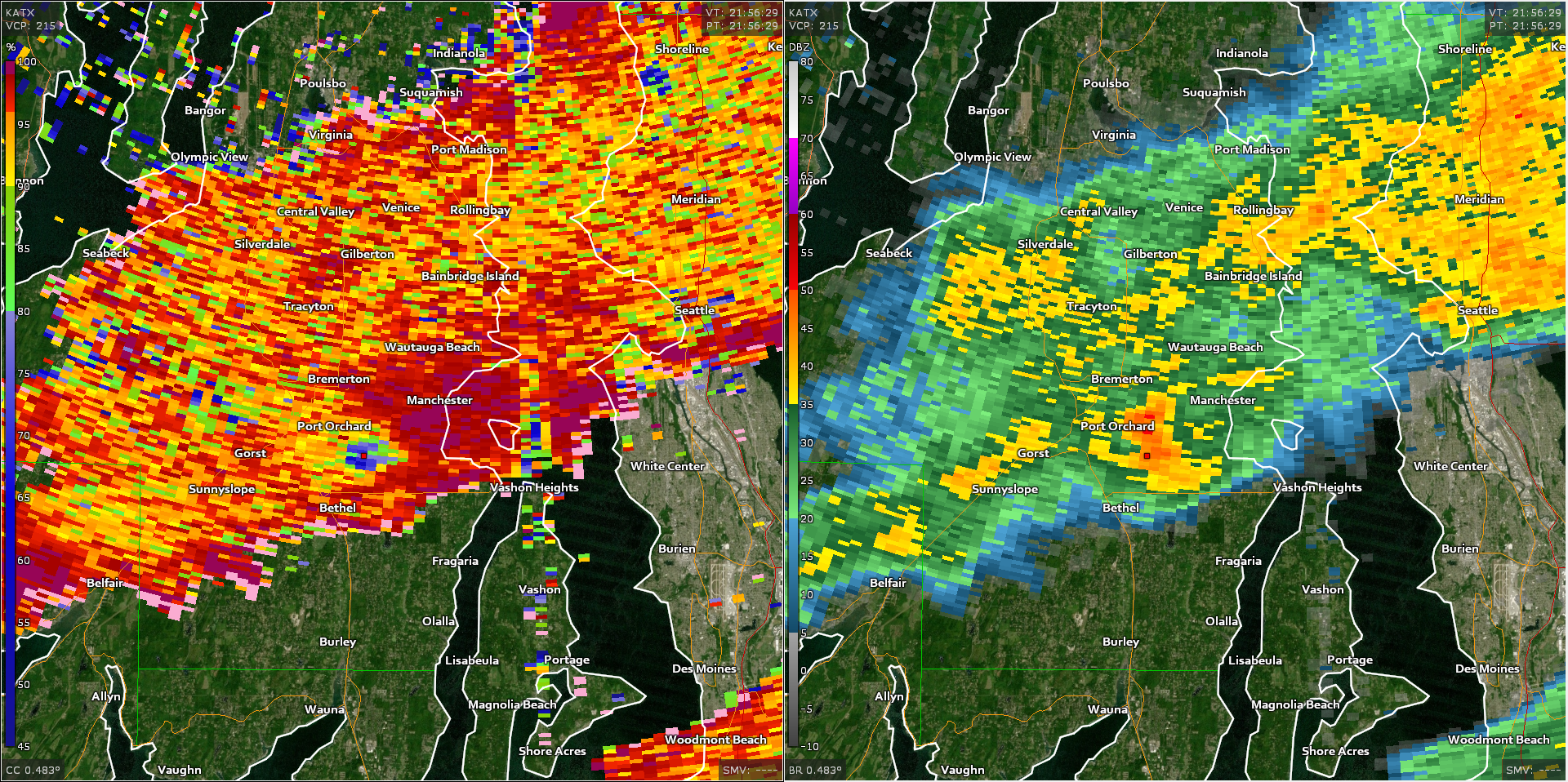
The debris on the CC imagery stands out as the dark blue circle near the center of the pane on the left. The radar beam is about 3,100 feet above ground level when it reaches the location of the tornado. Even if we didn’t have videos of the tornado in progress, a quick look at that kind of a debris signature that high above the ground is a sign of a strong and sizable tornado.

It’s common to see this somewhere like Alabama or Kansas, but not Washington. The Storm Prediction Center has more than 62,500 tornadoes in its database since reliable records began in 1950. Since then, only about 100 of those tornadoes occurred in Washington.
Heck, there are so few tornado tracks in Washington that you can barely make them out on a map of the whole country. You have to zoom in on the state to see them.

Most of the tornadoes reported in Washington over the past seven decades occurred along the coast, in valleys, and in the eastern part of the state where thunderstorms aren’t as hampered by terrain and a stable marine layer as out west. The majority of Washington’s tornadoes were relatively weak and short-lived.
The Storm Prediction Center‘s tornado database shows 121 tornadoes recorded in Washington between 1950 and 2017. More than half of those tornadoes—69 of them—were an F0 or EF-0 on the Fujita and Enhanced Fujita scales. (The Fujita scale was updated as the Enhanced Fujita Scale in 2007.) Only three tornadoes in Washington have produced F3/EF-3 damage. Based on pictures of the damage, today’s tornado is likely to get at least an EF-1 rating, if not higher.
Tornadoes are rare in Washington, and strong tornadoes are even rarer yet. They’re so rare, in fact, that the National Weather Service office in Seattle hasn’t issued a tornado warning in more than four years—including today. Residents of Port Orchard had no tornado warning or severe thunderstorm warning before the tornado touched down. They only knew there was a tornado if it hit them, they saw it, or they heard about it afterwards.
For all the talk of false alarms when it comes to tornado warnings, an uncomfortable fact we have to live with is that quite a few tornadoes actually wind up going unwarned. The National Weather Service fails to issue a tornado warning for 30-50% of all tornadoes that form each year. The agency does better warning for tornadoes that occur during organized outbreaks than in one-off situations like we saw today.
Please consider subscribing to my Patreon. Reader-funded news is more important than ever and your support helps fund engaging, hype-free weather coverage.

