Historic Heat Wave Produces Some Of The Hottest Temps Ever Recorded In October

Temperatures soared into the triple digits across parts of the southeastern United States this week at the peak of a historic late-late-season heat wave. Cities from the Gulf to the Great Lakes shattered all-time October high temperature records on Wednesday and Thursday, and many of those spots recorded temperatures hotter than any they saw during the summer.
It’s been hot. Really hot. It’s easy to forget that it’s the beginning of October with temperatures this darn hot. It’s funny…abnormally warm weather and shattered high temperature records are so common nowadays that we hardly notice them anymore. (Compare that to, say, the frenzied reaction to the major snowstorm that hit Montana and Alberta earlier this week.)
This major heat wave closes out what’s been a long and dry summer in much of the eastern part of the country. Some cities saw their earliest and latest 100+°F readings this year, beginning with a major heat wave in May and ending with this nonsense here in October.
It’s been a daunting task to keep up with all the records over the last couple of days; not just daily record highs, mind you, but all-time monthly high temperature records (which appear as pink dots on the following maps). Those are the hottest temperatures ever recorded at those stations during the month of October, with records stretching back more than 100 years in many locations.
Here’s a look at where high temperature records fell on Wednesday:
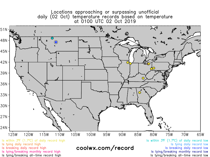 |
| Source: CoolWx.com |
…and a look at Thursday’s heat:
 |
| Source: CoolWx.com |
Dozens of reporting stations broke their all-time high temperature for the month of October on Wednesday, and many of those stations re-broke their all-time monthly high on Thursday. Some of those records weren’t close calls, either.
- Huntsville, Alabama, hit 100°F on both Wednesday and Thursday, which is the latest triple-digit readings—and the hottest October days—on record there.
- Raleigh, N.C., hit 100°F on Thursday, which is the latest triple-digit reading on record there.
- Birmingham, Alabama, broke its record high on each of the 9 days between September 26 and October 4.
- Charlotte, N.C., broke its record high on 7 out of the last 8 days, which, according to Brad Panovich, is the city’s longest streak of broken high temperature records in 140 years of recordkeeping.
- The summer began and ended with the earliest and latest 100°F readings on record in Augusta, Georgia. The city saw its earliest 100°F back at the end of May, and their latest 100°F occurred on Thursday. Columbia, S.C., also saw its earliest 100°F on record back in May, but missed its latest triple-digit reading by just two days this year.
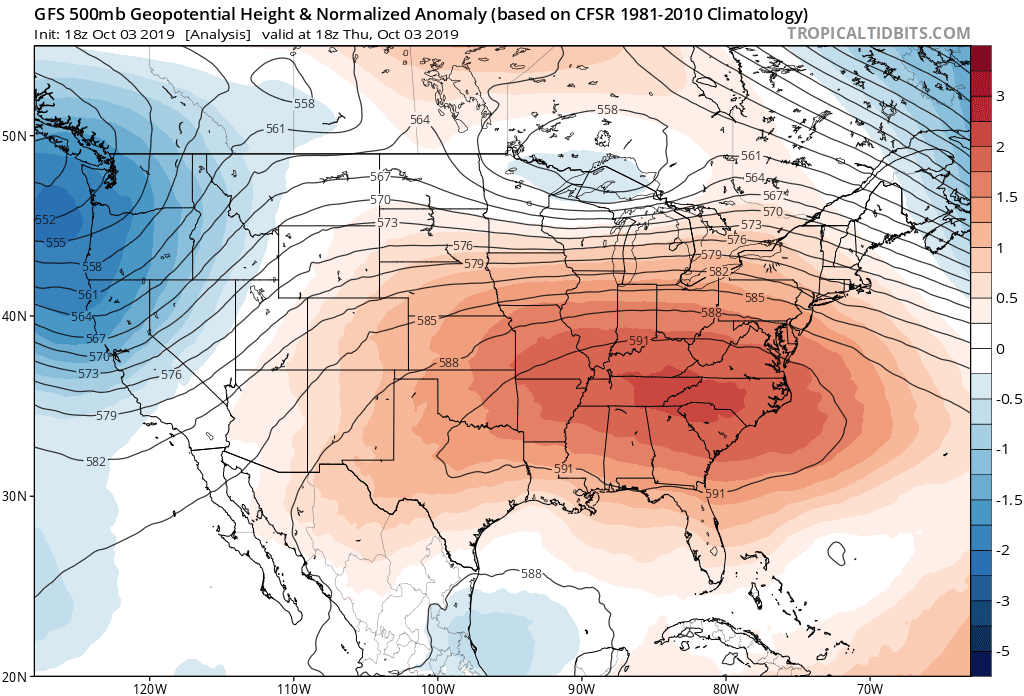 |
| 500 mb normalized height anomalies. Source: Tropical Tidbits |
A significant upper-level ridge parked over the eastern half of the United States is responsible for the excessive heat. Sinking air beneath a ridge of high pressure compresses as it reaches the surface, leading to the unpleasant warmth we’ve felt for the last couple of days. That sinking air also serves to put a lid on any convection or clouds, which is why you hardly get any relief from a passing cloud or afternoon shower.
Extremes beget extremes; the intense ridge over the eastern United States was directly related to the sharp trough over the Rockies earlier this week that brought historic early-season snows to parts of Montana and Alberta. Some spots saw as much as three feet of snow to begin the month of October, which is among the highest snowfall totals ever recorded during the month in those communities.
Speaking of extremes, it’s important to address the elephant in the room. Climate change increases the probability of seeing heat waves like this in the future. It’s hard to link directly link any one specific event to climate change; climate consists of patterns and trends, after all. Abnormal heat is certainly a trend. The five hottest years on record were 2016, 2017, 2015, 2018, and 2014. It’s likely that 2019 is going to rank high on the list at the rate things are going. Climate change exacerbates the extremes, meaning we’re likely going to see longer and more intense heat waves as the atmosphere warms and it begins to affect weather patterns.
Please consider subscribing to my Patreon. Your support helps me write engaging, hype-free weather coverage—no fretting over ad revenue, no chasing viral clicks. Just the weather.

