A Powerhouse Supercell Managed To Travel 300 Miles Across Three States

A real powerhouse of a supercell thunderstorm rolled across hundreds of miles of southern woodlands on Wednesday evening, ramping up in east-central Texas on Wednesday afternoon before finally petering out nearly eight hours later over the Mississippi River near Natchez, Mississippi. The supercell produced multiple tornadoes along its path, even prompting a tornado emergency as it approached Fort Polk, Louisiana.
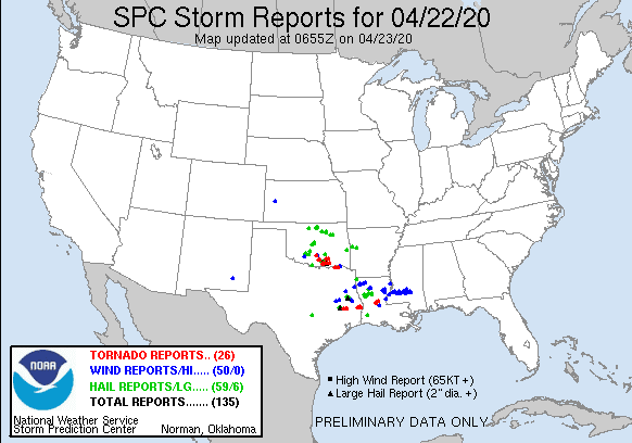
Wednesday saw a classic springtime severe weather event across the southern Plains and lower Mississippi Valley. A line of tornadic supercells developed along a dry line in central Oklahoma, including a tornado that killed two people and grew to frightening strength in a matter of seconds.
The environment was just as ripe for severe weather farther to the south in Texas. A single supercell managed to survive for eight hours as it tracked from College Station, Texas, to Natchez, Mississippi. The video above shows a radar loop (video by me, radar by College of DuPage) of the storm along its track from College Station to Natchez. It’s the southernmost storm that begins on the bottom-left and ends just right of center in the frame.
 |
| The thunderstorm near College Station that’d grow into the long-track supercell. (Gibson Ridge) |
A thunderstorm began to develop broad rotation near College Station, Texas, around 3:00 PM CDT, slowly growing more organized over the next couple of hours as it moved east of the town. Things got going in a hurry as the supercell moved south of Lufkin, Texas, around 5:30 PM CDT, producing the first in a series of tornadoes that would touch down between there and central Louisiana through the evening.
 |
| A tornado east of Jasper, Texas. (Gibson Ridge) |
The supercell neared peak strength once it got into far eastern Texas, cycling through stronger and weaker phases as it moved into Louisiana. The radar image above shows the storm around 7:30 PM CDT, as it approached the Texas/Louisiana border. It’s broken down into four panels:
- The top-left panel shows reflectivity, or precipitation.
- The top-right panel shows velocity, or wind. Green shows wind blowing toward the radar (to the east), while red shows wind blowing away from the radar. When you have a strong, tight cluster of red and green right next to each other, it shows strong rotation within a storm.
- The bottom-left panel shows correlation coefficient. The radar beam can tell us how similar in shape and size the objects are that it’s intercepting. Uniform objects like raindrops have a high correlation coefficient (red/purple), while mismatched objects like tornado debris have a very low correlation coefficient (blue). When you see a dark blue dot in the same spot as tight rotation, you’re looking at debris swirling around a tornado.
- The bottom-right panel is normalized rotation, or NROT. This is an algorithm within Gibson Ridge’s radar program that helps you quickly spot areas of rotation. Higher NROT values can indicate stronger rotation.
 |
| A tornado approaching Fort Polk, Louisiana, on April 22, 2020. (Gibson Ridge) |
This storm appears to have produced several strong tornadoes across eastern Texas and central Louisiana. The National Weather Service in Lake Charles, Louisiana, had to issue a tornado emergency for Fort Polk, a military training site that houses thousands of troops and their families, as a confirmed tornado moved very close to the heart of the base.
The storm continued producing possible tornadoes as it passed southeast of Alexandria, Louisiana, before the updraft weakened and the storm finally started falling apart as it crossed the Mississippi River south of Natchez, around 11:00 PM CDT. The storm powered along almost uninterrupted for eight hours (!!!) before it finally fell apart.
A supercell is powered by a rotating updraft. Strong wind shear can cause horizontal rolling motions in the atmosphere. If a strong thunderstorm can develop in that environment, the updraft will push that rotation into the vertical and the updraft itself will begin to rotate. This rotating updraft then tilts downwind, allowing the storm to ingest unstable air and vent cooler air without choking itself off like a “normal” thunderstorm would.
This was a rather unusual testament to the endurance of a supercell when it’s in a near-pristine environment. We usually don’t see this kind of a marathon run outside of major outbreaks.
We’re used to hearing about supercells after a tragic tornado or major hailstorm, but the vast majority of supercells are relatively—relatively—weak and don’t last for very long. Supercells can be extremely fragile, falling apart if their outflow moves too quickly or if nearby storms contaminate the environment ahead of them with stable air. It’s quite something to watch a supercell on radar practically disappear in just a few frames. But there was nothing in this storm’s way and it took full advantage of the situation.
Update: I changed the headline from “Tornadic Supercell Travels Farther In One Day Than You’ve Gone In The Last Two Months” to “A Powerhouse Supercell Supercell Managed To Travel 300 Miles Across Three States” because…well, do I really need to explain?
Please consider subscribing to my Patreon. Your support helps me write engaging, hype-free weather coverage—no fretting over ad revenue, no chasing viral clicks. Just the weather.

