Skip to content
DAMWeather DAMWeather

The weather can get scary. Reporting on it doesn't have to be.

DAMWeather DAMWeather

The weather can get scary. Reporting on it doesn't have to be.

  • About Me
  • All Bylines
    • Books, Bylines, and Press
    • The Skies Above (Book)
    • Extreme Weather (Book)
    • The Weather Network
    • The Vane
    • Forbes
    • Capital Weather Gang
    • Mental Floss
  • Maps
    • Hurricane Maps
    • Hurricane Names
    • Monthly Tornadoes
    • Tornado Tracks
    • F5/EF-5 Tornadoes
    • SPC High Risk Days
  • GIS Resources
  • Contact Me
    • Bluesky
    • Facebook
    • Instagram
  • wxdam.com

April Starts With Thundersnow And A Frigid Chill On The Northern Plains

By Dennis Mersereau
April 3, 2020 2 Min Read

The northern Plains is still clinging to winter as a push of Arctic air descends over the region and a round of snow to close out the first week of April. Periods of snow will bring up to half a foot of accumulation to parts of North Dakota and Minnesota through Friday before the skies clear out in time for the weekend. Parts of South Dakota experienced a full-fledged wintry thunderstorm on Thursday afternoon, complete with hundreds of lightning strikes mixed in with snow, sleet, and freezing rain.

A cold front barreling across the Plains on Thursday made itself known in a hurry. There’s a 30-40°F difference between temperatures across the boundary; shorts weather earlier today turned into winter-coat-fireplace-hot-cocoa-stay-in-bed weather in just a couple of minutes once the front rolled overhead. Temperatures quickly fell into the teens across the Dakotas on Thursday, and the chill will continue toward the Upper Midwest over the next day or so.

Thursday afternoon’s forecast from the National Weather Service shows a decent blanket of snow covering most of the Dakotas and northern Minnesota by Friday night. The heaviest totals are likely along the Red River between Fargo and southern Saskatchewan. Parts of northwestern Minnesota could see up to half a foot of snow by the end of the storm.

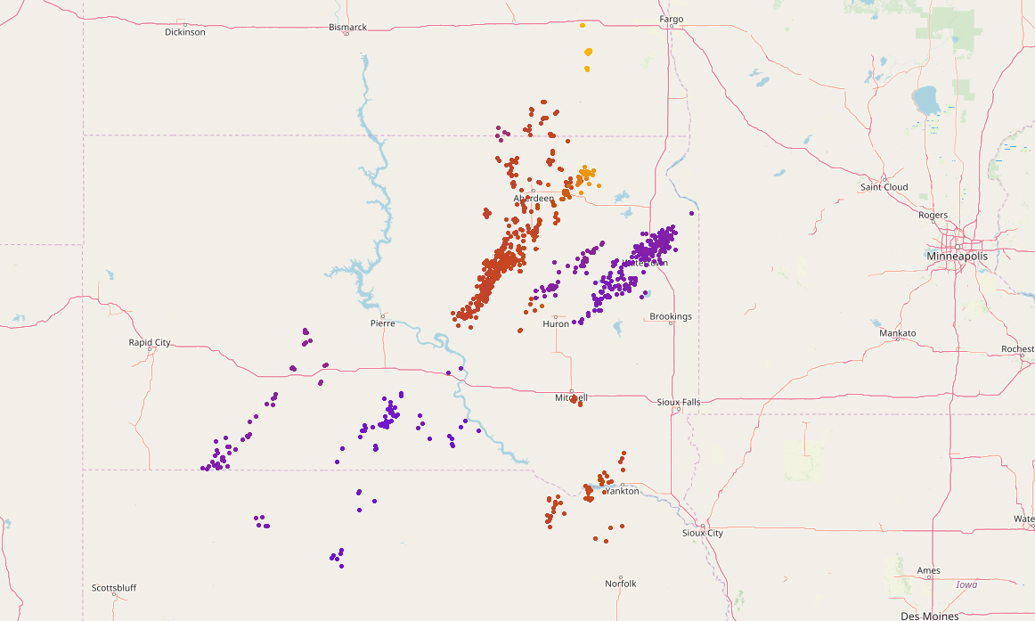
Lightning strikes across South Dakota on Thursday afternoon. | Source: LightningMaps.org

It’s not uncommon to see accumulating snow this far north at the beginning of April; Fargo averages about 3 inches of snow in a typical April. But it is uncommon to see such an intense bout of thundersnow/thundersleet/thunderfreezingrain (hey, we’re working with limited terms here) as folks in central and eastern South Dakota experienced on Thursday afternoon. An intense line of convection moved across the state around lunchtime on Thursday and produced a heavy wintry mix with hundreds of cloud-to-ground lightning strikes embedded within. The map above shows the history of lightning strikes as the wintry squall moved through the region.


You can follow me on Twitter or send me an email.

Please consider subscribing to my Patreon. Your support helps me write engaging, hype-free weather coverage—no fretting over ad revenue, no chasing viral clicks. Just the weather.
 

Author

Dennis Mersereau

I have 15+ of experience providing hype-free weather information for folks across the United States and around the world. In addition to DAMWeather, I also contribute to The Weather Network as a digital writer and weather specialist.

Follow Me
Other Articles
Previous

Some Strong Tornadoes Are Possible In Alabama And Tennessee On Tuesday Evening

Next

A Significant Severe Weather Outbreak Is Possible Across The Southeast On Easter Sunday


Local ◈ UTC
Facebook | Bluesky
Instagram | Threads | Email
DAMWeather is now ad-free! Everyone benefits from engaging, hype-free weather coverage. Please consider supporting my efforts through Patreon:


Order The Skies Above today!

Bookshop.org || Barnes & Noble
Mountaineers Books || Amazon

My latest book, The Skies Above, is now available!

Did you know a puffy cloud can weigh millions of pounds? Or that every rainbow you see is unique to you?

Our atmosphere is full of spectacular sights that are always within your reach. Glistening layers of fog, gorgeous sunsets, and brilliant meteors flashing through the sky can light up even the calmest day.

The Skies Above, published by Mountaineers Books, is a celebration of what we overlook when we look up. I was thrilled to work with the editors and illustrators at Indelible Editions to share with you the quotidian beauty of our sky.

Order your copy now and learn about the wonders we take for granted every day.

I teamed up with the editors of Outdoor Life magazine to write The Extreme Weather Survival Manual, your guide to surviving and thriving in almost any weather condition. Whether you're an avid outdoorsperson or you enjoy watching the radar from the comfort of your home, you're sure to find helpful tips, advice, and new bits of knowledge in this fascinating book.

You can buy my book today through Amazon.
An error has occurred, which probably means the feed is down. Try again later.
  • 2026 (30)
  • 2025 (49)
  • 2024 (59)
  • 2023 (43)
  • 2022 (57)
  • 2021 (71)
  • 2020 (83)
  • 2019 (88)
  • 2018 (92)
  • 2017 (1)
  • 2016 (4)
  • 2015 (10)

Copyright 2026 — DAMWeather. All rights reserved. Blogsy WordPress Theme