Dangerous Overnight Storms Likely On The Northern Gulf Coast Into Friday Morning
A potent low-pressure system trekking across the southern United States will spawn a risk for severe weather across much of the southeast over the next couple of days. The greatest threat will target parts of the northern Gulf Coast overnight Thursday into Friday morning, where we could see a couple of strong tornadoes develop.
All the ingredients are in place for widespread severe thunderstorms over the next 24-36 hours across the southeastern states. We’ve already seen a couple of hail-happy supercells in central Oklahoma this evening. The system responsible for those storms will continue moving east, setting the stage for more severe weather continuing overnight into the day on Friday.
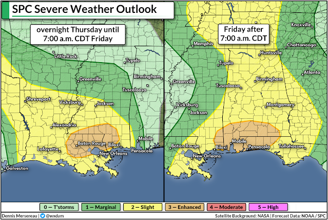
The Storm Prediction Center issued an enhanced risk—a three out of five on the severe weather risk scale—from southeastern Louisiana through the western Florida Panhandle, covering New Orleans, Biloxi, Gulfport, Mobile, and Pensacola. These risk maps are split between two different days because the SPC’s forecasts reset at 7:00 a.m. CDT each day.
While the risk for damaging winds and large hail is an ever-present threat with any springtime severe thunderstorm in the south, there’s enough wind shear present over the northern Gulf Coast to bring the region an enhanced risk for tornadoes.
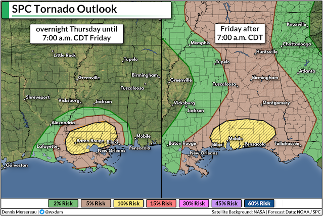
The SPC’s outlooks note that there’s a 10% risk for strong, long-lived tornadoes that justifies the enhanced risk. 10% doesn’t sound like much, but consider the average odds of a tornado within 25 miles of the northern Gulf Coast on March 18th is about 0.20%.
This is especially dangerous because much of the severe weather will unfold overnight and during the early morning hours, when people are sleeping or otherwise tuned out from severe weather coverage.
Nighttime severe weather is a scary way of life in the south. If you live in this area (or if you know someone who does), please make sure emergency alerts for tornado warnings are activated on your smartphone. This feature, while annoying, is a proven lifesaver and could be the only thing standing between you and severe injury or death if the unthinkable happens.
In addition to your smartphone, it’s a great idea to have multiple ways to receive severe weather alerts. Weather radios are great. Even leaving the television on a local news station overnight is good so that you might catch a glimpse of live coverage or hear the beeps when a warning is issued.
Always trust the warnings and get ready to act as soon as you hear the alert. And please, please, do not rely on tornado sirens for warnings. They’re unreliable relics that aren’t designed to be heard indoors.
You can follow me on Twitter or send me an email.
Please consider subscribing to my Patreon. Your support helps me write engaging, hype-free weather coverage—no fretting over ad revenue, no chasing viral clicks. Just the weather.

