


The first real rip-roarin' winter storm of the season is cranking up over the Plains states this evening.
The storm will kick into high gear heading into Tuesday, bringing blizzard conditions and a full-on ice storm to parts of the High Plains, while folks across parts of the south have to deal with the risk for severe thunderstorms and tornadoes.


A fast-developing low over northeastern Colorado will strengthen over the next 12-24 hours as a strong jet stream moves across the Rockies.
This large system will have a little bit of everything for everyone—it'll be one of those classic winter storms that puts on a gorgeous curly display when we gawk at satellite imagery on Tuesday and Wednesday.
The northern side of the storm will have plenty of cold air for heavy snow and freezing rain to fall over the northern Plains.
Forecasters expect the worst conditions to cover communities from northeastern Colorado into the Dakotas.

It's not heavily populated terrain by any means, but it'll be a disruptive storm for folks who live in the area, and it'll make life difficult for cross-country travelers by road and rail.
The latest forecast from the National Weather Service calls for widespread totals of more than a foot of snow across the hardest-hit areas, with more than two feet of snow possible for some (un)lucky towns, especially in South Dakota.
Closer to the track of the low itself, warm air nosing its way into the lower-levels of the atmosphere will lead to a prolonged freezing rain event.
An ice storm warning is in effect for parts of eastern South Dakota, including Brookings, for the potential for 0.25 to 0.50 inches of ice accretion. That's more than enough solid ice to bring down tree limbs and power lines.
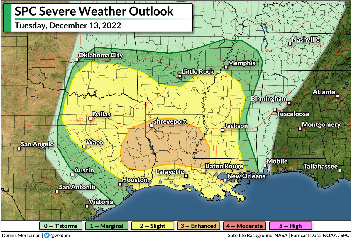
A solid stream of warm, moist air pumping north from the Gulf will fuel a widespread risk for severe thunderstorms through midweek. The greatest risk will play out on Tuesday, with the Storm Prediction Center issuing an enhanced risk for severe weather (a 3 on the 1-5 scale) centered on much of Louisiana.
The biggest concern with Tuesday's storms will be the risk for tornadoes. The environment may be capable of producing significant, long-track tornadoes. If you're in or near the region at greatest risk, keep an ear out for severe thunderstorm and tornado warnings and have safe shelter nearby you can reach in a hurry.

Snow, ice, and tornadoes aren't this storm's only risks. We're looking at the risk for several inches of rain across the southeastern states over the next couple of days. This steady march of heavy rain will beef up the potential for flash flooding in vulnerable areas.
This storm will spin itself out (to use the technical term) by Thursday, with its remnant moisture going on to feed the development of another system along the East Coast by the end of the week.

You can follow me on Twitter or send me an email.
Please consider subscribing to my Patreon. Your support helps me write engaging, hype-free weather coverage—no fretting over ad revenue, no chasing viral clicks. Just the weather.
Please consider subscribing to my Patreon. Your support helps me write engaging, hype-free weather coverage—no fretting over ad revenue, no chasing viral clicks. Just the weather.


0 comments: