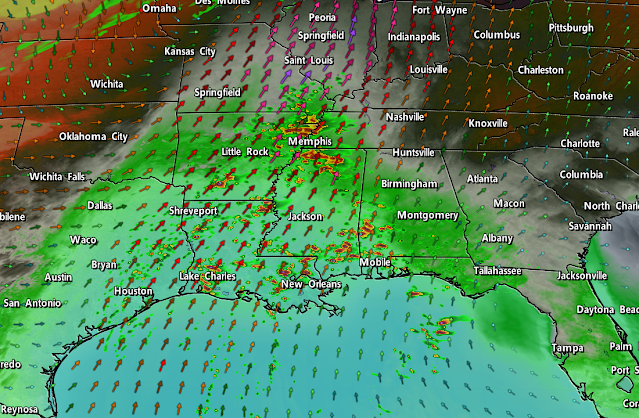
We're staring down a classic late-fall severe weather setup across parts of the southern United States on Tuesday, and forecasters are concerned about the potential for significant tornadoes in the Mid-South as storms fire up through the day.
A low-pressure system developing over the Midwest will drag warm, moist air north from the Gulf of Mexico. A cold front will crash into this instability, providing the spark needed for thunderstorms to fire up across the lower Mississippi River Valley.
There's enough wind shear through the atmosphere to allow some of those thunderstorms to grow into supercells. Forecasters with the Storm Prediction Center are worried there will be enough instability and 'spin' in the atmosphere to produce strong, long-lived tornadoes across the region.
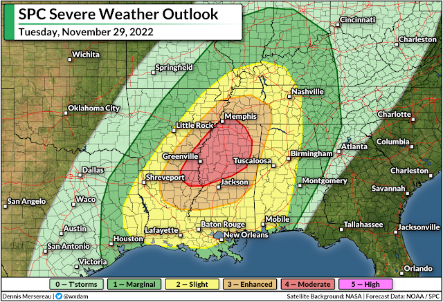
Anticipating the threat, the SPC issued a moderate risk for severe weather across parts of Louisiana, Arkansas, Mississippi, and southwestern Tennessee for the day on Tuesday. A moderate risk is a 4 out of 5 on the scale measuring the risk for severe thunderstorms on a given day. Significant, long-lived tornadoes are also possible throughout the enhanced risk zone that covers larger portions of those four states.
Thunderstorms will fire up during the late morning hours, peaking in intensity and coverage through Tuesday afternoon. As we usually see during a setup like this, the storms will likely begin to merge and evolve into one or more squall lines as we close in on the evening hours, transitioning the threat over to damaging straight-line winds with a risk for embedded tornadoes.
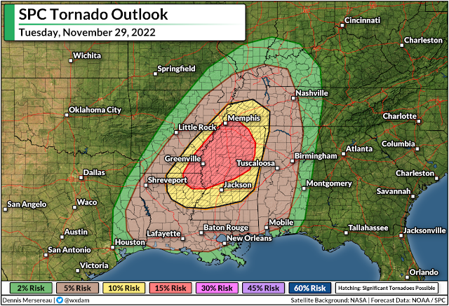
Given the potential for supercells, the biggest concern here is the potential for one or more significant tornadoes. The SPC issued the moderate and enhanced risks almost entirely based on Tuesday's tornado threat. The black hatching indicates the risk for strong, long-lived tornadoes. A 10-15% chance for tornadoes doesn't seem like much, but it's all relative considering the average odds of seeing a tornado on any given day is basically nil.
 |
| The greatest chance of tornadoes at the end of November is right around where we're expecting severe weather on Tuesday. (NOAA/SPC) |
Severe weather is common in the southern U.S. during the late fall and winter months, and it's for pretty much the same reason we see a huge uptick in severe weather during the spring months. Spring and fall are both transition seasons that strengthen the jet stream, giving way to robust low-pressure systems that can foster severe thunderstorms.
Make sure you have a way to receive warnings the moment they're issued. Check your phone and ensure that emergency alerts are activated for tornado warnings. These free push alerts may be annoying, but they're proven lifesavers and can alert you to a tornado warning for your location before many other apps or devices do. Seconds count when a dangerous storm is barreling toward you.
[Top image created using WSV3]
You can follow me on Twitter or send me an email.
Please consider subscribing to my Patreon. Your support helps me write engaging, hype-free weather coverage—no fretting over ad revenue, no chasing viral clicks. Just the weather.
Please consider subscribing to my Patreon. Your support helps me write engaging, hype-free weather coverage—no fretting over ad revenue, no chasing viral clicks. Just the weather.


0 comments: