Skip to content
DAMWeather DAMWeather

The weather can get scary. Reporting on it doesn't have to be.

DAMWeather DAMWeather

The weather can get scary. Reporting on it doesn't have to be.

  • About Me
  • All Bylines
    • Books, Bylines, and Press
    • The Skies Above (Book)
    • Extreme Weather (Book)
    • The Weather Network
    • The Vane
    • Forbes
    • Capital Weather Gang
    • Mental Floss
  • Maps
    • Hurricane Maps
    • Hurricane Names
    • Monthly Tornadoes
    • Tornado Tracks
    • F5/EF-5 Tornadoes
    • SPC High Risk Days
  • GIS Resources
  • Contact Me
    • Bluesky
    • Facebook
    • Instagram
  • wxdam.com

Buffalo Could See 4-5 Feet Of Snow Through The Weekend, As One Does

By Dennis Mersereau
November 18, 2022 2 Min Read

Oh dear. 
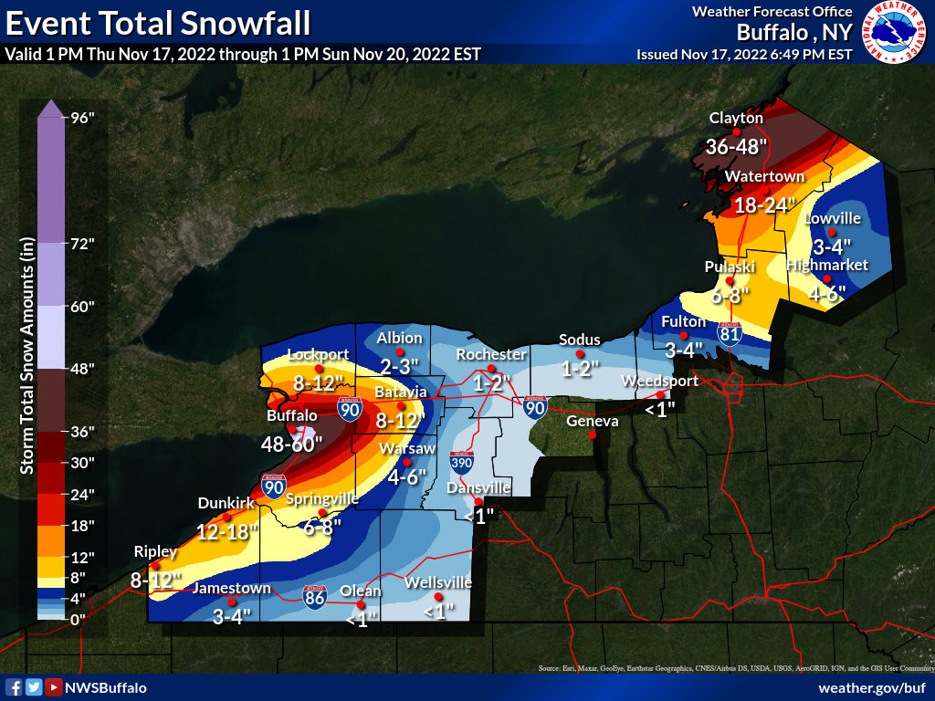
A vigorous lake-effect snowstorm is about to get underway in western New York, where the National Weather Service expects 4-5 feet…feet…of snow to fall across the Buffalo metro area by Sunday.
This will be a lake-effect event for the ages, so long as “the ages” stop back in 2014, when a very similar setup resulted in 65 inches of snow falling south of Buffalo in a couple of days.
NWS Buffalo

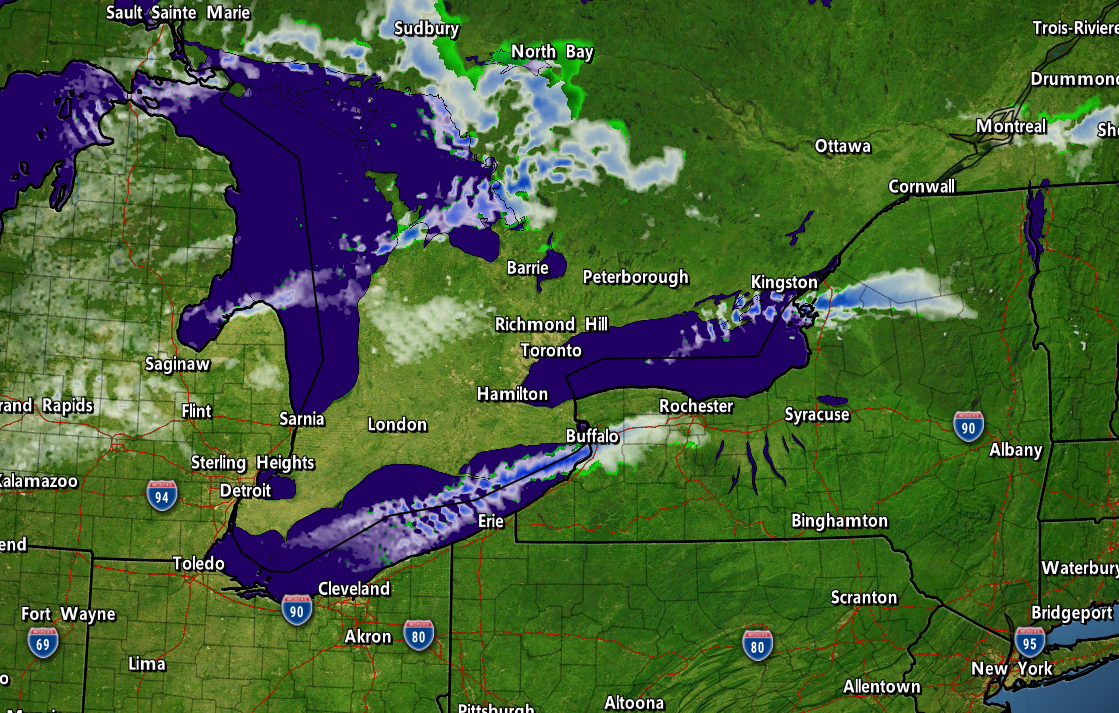
We’re witnessing a classic event that’ll probably land in some meteorology instructor’s PowerPoint slides one day.
Cold winds blowing across the Great Lakes behind a cold front are setting the stage for ripping bands of snow to develop across the eastern Lakes.
These southwesterly winds will align perfectly along the length of Lake Erie to instigate the development of a long, steady band of snow that’ll train its fire on the Buffalo metro area. The band of snow will pick up in earnest overnight Thursday into Friday, continuing into the day Saturday for many areas.
The band will ultimately wobble a few miles to the left and a few miles to the right, but forecasters are confident that this will be a high-impact storm that’ll smack Buffalo one good.
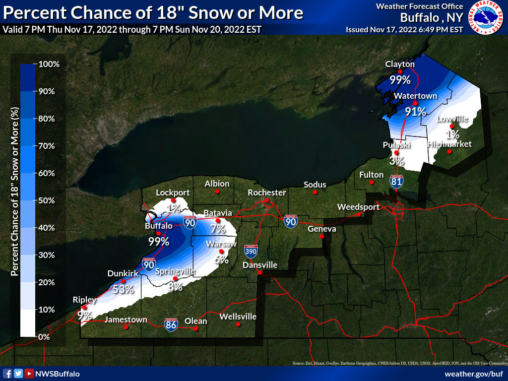
NWS Buffalo gives the city a 99% chance of seeing at least 18 inches of snow over the next couple of days, and the office’s official forecast casually paints a bullseye of 48-60 inches of snow over the city.
NWS Buffalo

What’s behind this? Much like thunderstorms on a warm day, lake-effect snow forms through convection. The lakes hold on to their heat really well even as the air turns bitterly cold, setting up a sharp temperature gradient between the lower levels and the upper levels.
The warm lakes heat up the air directly above them, allowing the air to rise and trigger snow showers. Winds organize the showers into bands. A scenario like the one we’re seeing now—a great temperature difference combined with winds perfectly aligned with the length of Lake Erie—will lead to…well, the road-glaciating event we’re about to witness.
Buckle up, western New York. This’ll be one you talk about with the gusto of a shipwreck survivor when the south falls apart in two inches of snow in a few months.
[Top image created with WSV3]


You can follow me on Twitter or send me an email.

Please consider subscribing to my Patreon. Your support helps me write engaging, hype-free weather coverage—no fretting over ad revenue, no chasing viral clicks. Just the weather.


Author

Dennis Mersereau

I have 15+ of experience providing hype-free weather information for folks across the United States and around the world. In addition to DAMWeather, I also contribute to The Weather Network as a digital writer and weather specialist.

Follow Me
Other Articles
Previous

Hurricane Warnings Continue As Sprawling Nicole Nears Florida Landfall

Next

Strong Tornadoes Are Possible Across The Mid-South On Tuesday


Local ◈ UTC
Facebook | Bluesky
Instagram | Threads | Email
DAMWeather is now ad-free! Everyone benefits from engaging, hype-free weather coverage. Please consider supporting my efforts through Patreon:


Order The Skies Above today!

Bookshop.org || Barnes & Noble
Mountaineers Books || Amazon

My latest book, The Skies Above, is now available!

Did you know a puffy cloud can weigh millions of pounds? Or that every rainbow you see is unique to you?

Our atmosphere is full of spectacular sights that are always within your reach. Glistening layers of fog, gorgeous sunsets, and brilliant meteors flashing through the sky can light up even the calmest day.

The Skies Above, published by Mountaineers Books, is a celebration of what we overlook when we look up. I was thrilled to work with the editors and illustrators at Indelible Editions to share with you the quotidian beauty of our sky.

Order your copy now and learn about the wonders we take for granted every day.

I teamed up with the editors of Outdoor Life magazine to write The Extreme Weather Survival Manual, your guide to surviving and thriving in almost any weather condition. Whether you're an avid outdoorsperson or you enjoy watching the radar from the comfort of your home, you're sure to find helpful tips, advice, and new bits of knowledge in this fascinating book.

You can buy my book today through Amazon.
An error has occurred, which probably means the feed is down. Try again later.
  • 2026 (30)
  • 2025 (49)
  • 2024 (59)
  • 2023 (43)
  • 2022 (57)
  • 2021 (71)
  • 2020 (83)
  • 2019 (88)
  • 2018 (92)
  • 2017 (1)
  • 2016 (4)
  • 2015 (10)

Copyright 2026 — DAMWeather. All rights reserved. Blogsy WordPress Theme