North Carolina’s snowy season is over—not that we had one this year
April 24 is a milestone in North Carolina’s everlasting battle against wintry weather.
That fateful Sunday back in 2005 was the latest on record we’ve seen measurable snow in a major city in North Carolina.
An observer at Asheville Regional Airport recorded 0.1″ of snow on that date 18 years ago, a mere dusting among dustings that stands as the latest in the year in modern times we’ve seen a verified snow measurement in one of the state’s big cities.
Passing this marker in winter weather history doesn’t seem to matter much this year, though, seeing as we just witnessed a near-historic snow drought across North Carolina.
A Rare Near-Snowless Winter Across North Carolina
Despite our reputation for falling to pieces the moment someone spots the first flake, it snows just about every year in North Carolina.
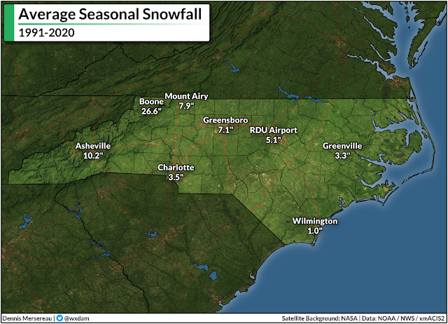
Even folks down by the coast sweep away an inch of snow every year or so. Once you’re west of Interstate 95, it’s actually pretty unusual not to see at least a dusting of snow every year, making this winter’s lack of wintry precipitation all the more conspicuous.
Every weather station in a shade of blue on the map below actually managed to record measurable snow (≥ 0.1″) at some point this past winter:

…and every weather station in red on the map below recorded no measurable snow this past winter:
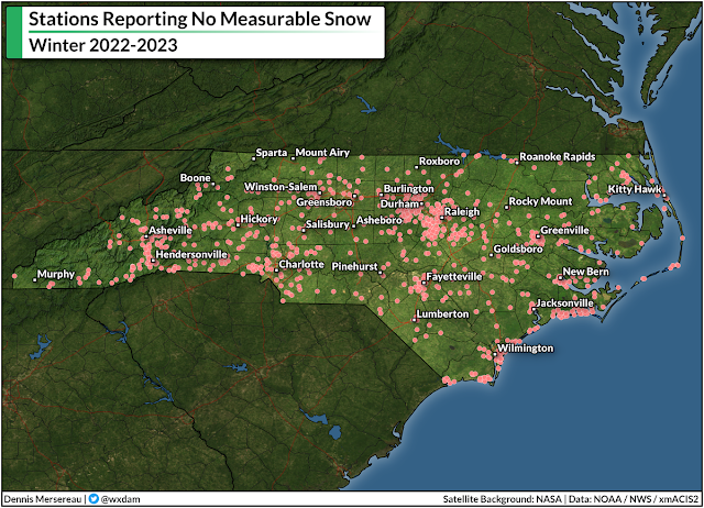
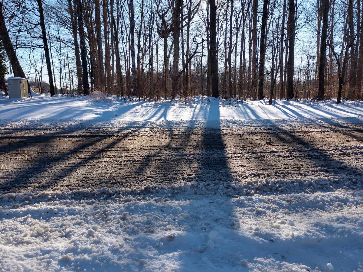
Almost all of this year’s accumulating snow remained in the mountains, while a short-lived dusting managed to survive into pockets of the northern piedmont toward the end of March.
The most snow we saw at lower elevations was a “trace,” which occurs when snow falls but melts on contact with the ground. Recording a trace gives meteorologists the ability to note that it snowed even though it didn’t accumulate.
If you look at how folks drive and react to any predicted amount of snow, you’d think that every winter storm was our very first one. While we’re far enough south that winters are generally tolerable to the warmth-inclined, we’re also just high enough in latitude to get clipped by snow and ice storms on a regular basis.
Our major cities each benefit from generous weather records that stretch back to the mid-1940s or earlier, a depth that gives us solid frames of reference for what’s normal and how fast our “normal” is changing these days.
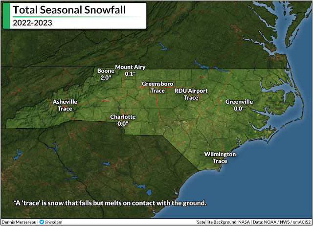
Asheville, for instance, has seen measurable snow every winter for the past 70+ years except for just four. With just a trace of snow recorded at the airport, this year ranks among those four. Boone has recorded snow every single winter since 1928; however, the 2.0″ that fell there this winter was the lowest out of nearly a century of routine observations.
It’s a similar story in our low-elevation metro areas. The big goose-egg measured in Charlotte this winter was one of just 11 winters where no measurable snow fell. Greensboro’s trace of snow made this the sixth winter since 1928 where we couldn’t even muster a dusting.
The lack of snow isn’t for a lack of precipitation, either. Most stations west of I-95 saw slightly below-average precipitation, only by an inch or so. The mountains and piedmont managed to avoid drought all winter, with “unusual dryness” only starting to creep into northern sections around Rockingham and Caswell Counties here at the end of April.
It could have snowed. It should have snowed. But it didn’t snow because it was just too warm to snow.
Record Winter Warmth
Calling the previous season “winter” even feels like an overstatement. It was pre-spring. Spring Junior. Aside from the epic cold snap that nearly wrecked our power grid in the days leading up to Christmas, this winter put a capital M in Mild.
The most “winter” we experienced last season was a lobe of the polar vortex that descended upon the United States right around Christmas. Temperatures plummeted into the single digits for much of North Carolina on Christmas Eve.
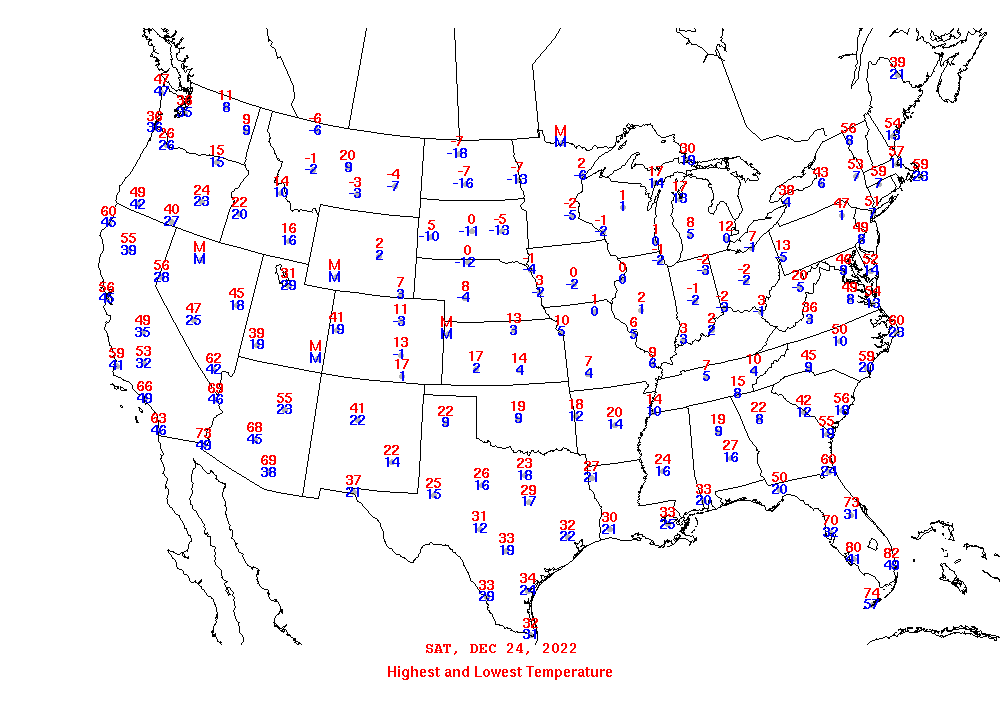 |
| Highs and lows on December 24, 2022. (NOAA) |
Such a spell of cold weather isn’t unprecedented here, but a series of maddening failures and poor decisions on Duke Energy’s part plunged hundreds of thousands of North Carolina homes into the dark on those coldest mornings, a series of self-imposed blackouts designed to prevent cascading damage to the power grid as a result of sub-standard power generation.
Other than that little hiccup…it just never really got all that chilly after Christmas.
This was still a capital-M Mild winter even when you factor in the atmosphere over northern Canada taking a brief sojourn south of the border.
Raleigh-Durham International Airport recorded its warmest-ever winter this past season. Boone achieved the same infamous feat. Folks in Charlotte, Greensboro, and Asheville all saw their fourth-warmest winters on record.
Almost all of this winter’s warmth wasn’t necessarily driven by days that were mild enough for short-sleeve shirts, but rather nights that repeatedly came in warmer than normal. Average nighttime lows across the state came in well above normal throughout the entire season, widely ranking among the top-three warmest on record.
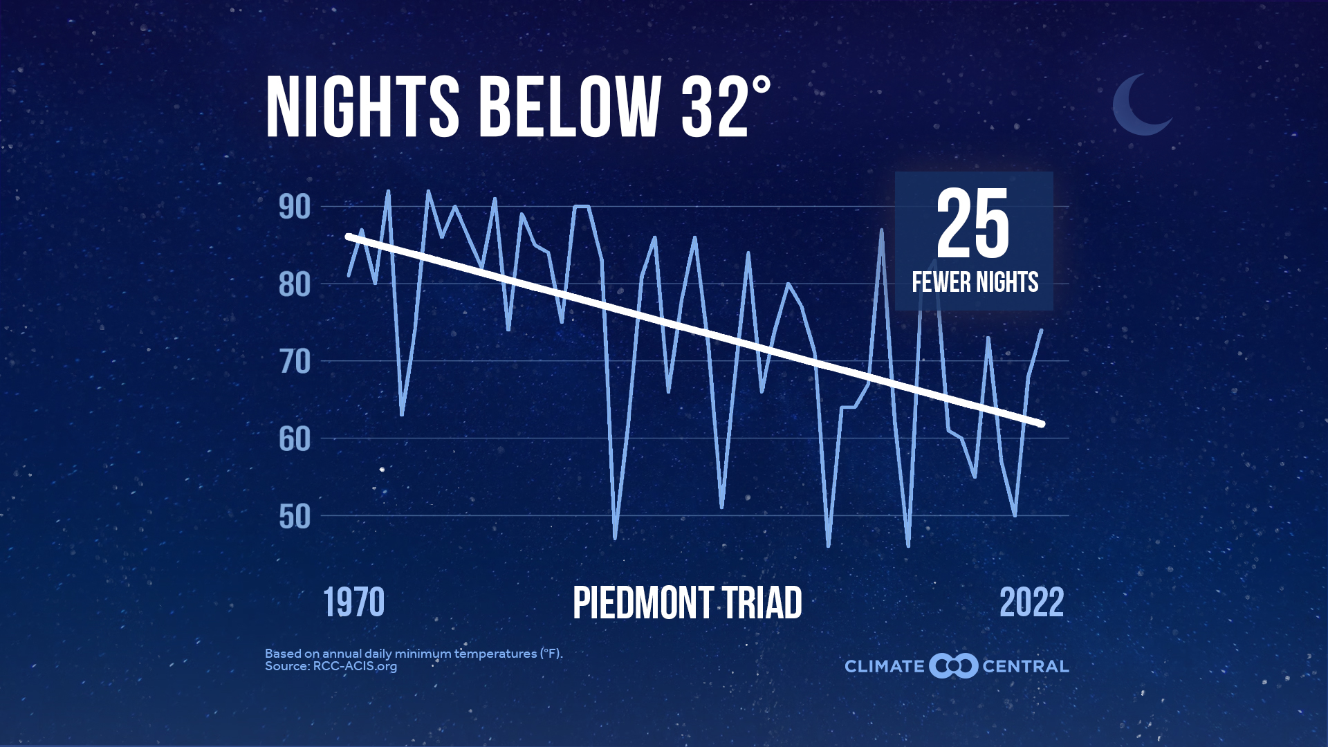 |
| Source: Climate Central |
That’s not much of a surprise, unfortunately. Rising low temperatures are one of the most tangible ways we’re experiencing climate change here in North Carolina. Low temperatures throughout the year have risen at an astonishing rate over the past couple of decades. The change is so pronounced here in the Triad that we’ve lost more than three full weeks of subfreezing nights since the 1970s.
We’re still going to have finger-numbing cold in winters to come. It’ll probably snow next winter, and there’s a decent chance parts of the state will see a disruptive thumping from one of those wintry storms.
But the ongoing trend of warmer winter temperatures, especially warmer overnight low temperatures, will reduce our overall chances for snow going forward. It takes just a little more effort and alignment to get snow nowadays. It’s not our parents’ climate anymore. We experienced it firsthand this past winterless winter.
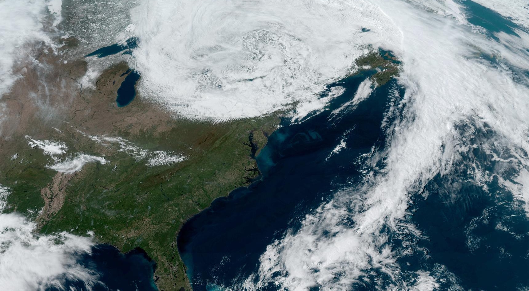
[Top satellite image via NOAA]


