Skip to content
DAMWeather DAMWeather

The weather can get scary. Reporting on it doesn't have to be.

DAMWeather DAMWeather

The weather can get scary. Reporting on it doesn't have to be.

  • About Me
  • All Bylines
    • Books, Bylines, and Press
    • The Skies Above (Book)
    • Extreme Weather (Book)
    • The Weather Network
    • The Vane
    • Forbes
    • Capital Weather Gang
    • Mental Floss
  • Maps
    • Hurricane Maps
    • Hurricane Names
    • Monthly Tornadoes
    • Tornado Tracks
    • F5/EF-5 Tornadoes
    • SPC High Risk Days
  • GIS Resources
  • Contact Me
    • Bluesky
    • Facebook
    • Instagram
  • wxdam.com

A Stagnant Weather Pattern Will Give Way to More Cool Weather for the Eastern U.S.

By Dennis Mersereau
March 30, 2018 3 Min Read

You didn’t think winter would go down without a fight, did you? The stagnant weather pattern that’s blanketed the United States this week is finally giving way and will be replaced by a pattern that will allow frequent shots of below-normal temperatures to dip across the eastern two-thirds of the United States over the next week.

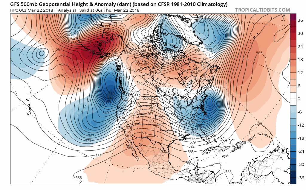
The pattern we’ve seen in the upper levels of the atmosphere resembled an omega block, which occurs when a stationary ridge of high pressure over the middle of North America is bookended by low-pressure systems on the western and eastern sides of the continent. An omega block leads to warm, calm weather in the center of the United States and Canada with unsettled weather on either coast.

The blocking pattern we experienced last week kept moving—albeit very slowly. This sluggishness allowed persistent showers and thunderstorms to develop over the southern half of the country, where flash flooding and severe thunderstorms were a serious issue for several days, especially across Texas and Louisiana.

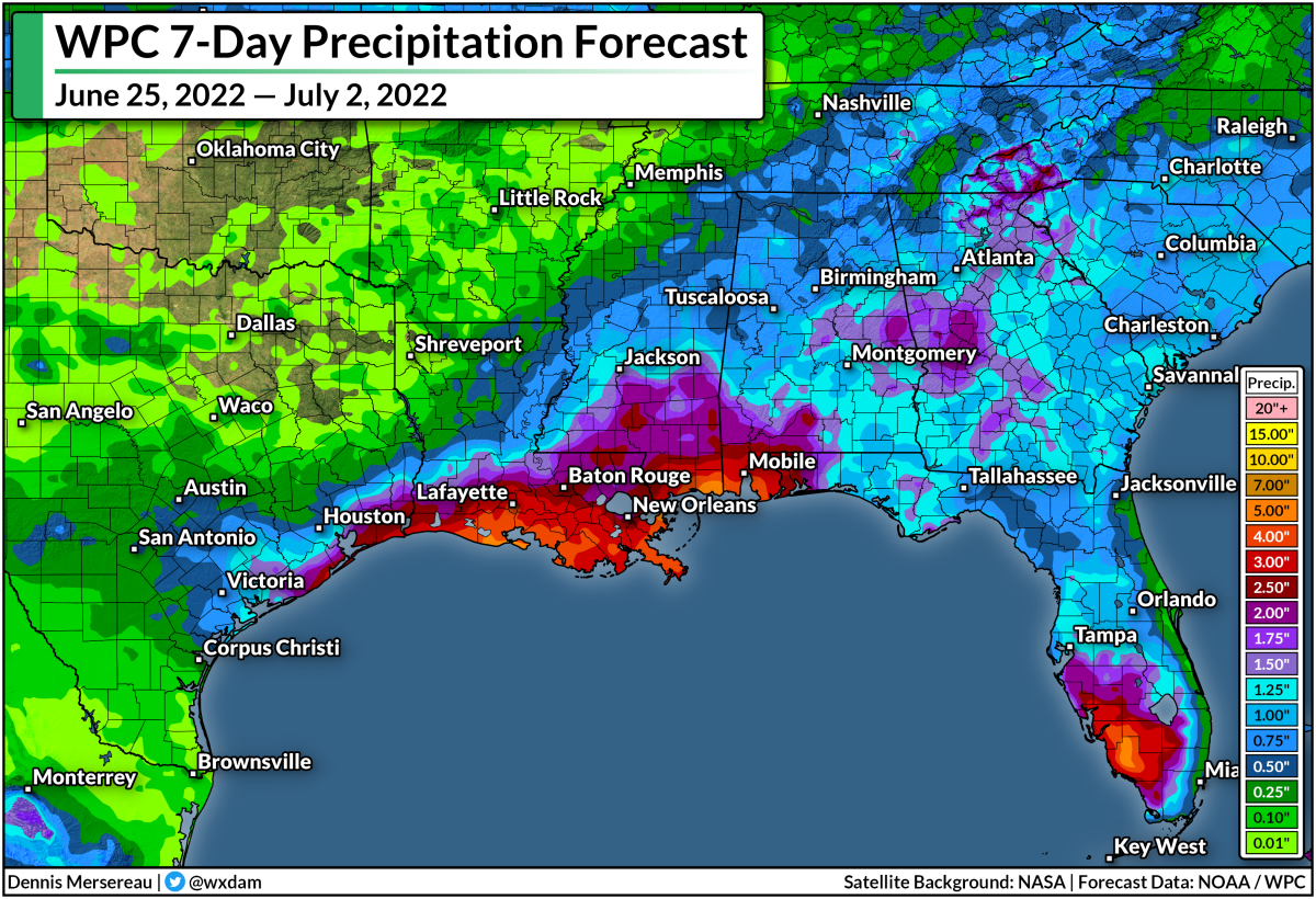
Some areas in Louisiana and Texas saw flash flooding from more than eight inches of rain from heavy rain thunderstorms training over the same spots for several days. Unfortunately, the most plentiful rainfall missed the areas hardest-hit by drought over the past few months. Areas that saw more than an inch of rain almost completely avoided parts of the country that are in some level of drought.

What can we expect over the next few days? Temperatures for most of us east of the Rockies will follow one of those classic, springtime up-down-up-down trends as storms and disturbances come and go. The Climate Prediction Center shows below-average temperatures for most of us east of the Rockies, while above-average temperatures and dry conditions continue for the western section of the country.

Snow should mostly be relegated to the Rockies and the northern states, where a fast-hitting winter storm could drop up to eight inches of snow in Minnesota and Wisconsin on Friday and Saturday. There’s a quick chance of snow or a wintry mix from Sunday into Monday from the central Plains through the Mid-Atlantic, but it shouldn’t amount to much if it snows at all. The sun angle is high enough this time of year that wintry precipitation won’t stick around very long if it accumulates at all.

Our next chances at significant weather should emerge toward the middle and end of next week, when heavy rain and thunderstorms are possible along and east of the Mississippi River, and a potential heavy rain event could welcome the first weekend of April for parts of the West Coast.

[Model: Tropical Tidbits | Rain Map: Dennis Mersereau | Temp. Outlook: NOAA / CPC]

Author

Dennis Mersereau

I have 15+ of experience providing hype-free weather information for folks across the United States and around the world. In addition to DAMWeather, I also contribute to The Weather Network as a digital writer and weather specialist.

Follow Me
Other Articles
Previous

A Note to the New Owners of The Weather Channel

Next

Widespread Severe Thunderstorms Expected in the Central U.S. on Tuesday


Local ◈ UTC
Facebook | Bluesky
Instagram | Threads | Email
DAMWeather is now ad-free! Everyone benefits from engaging, hype-free weather coverage. Please consider supporting my efforts through Patreon:


Order The Skies Above today!

Bookshop.org || Barnes & Noble
Mountaineers Books || Amazon

My latest book, The Skies Above, is now available!

Did you know a puffy cloud can weigh millions of pounds? Or that every rainbow you see is unique to you?

Our atmosphere is full of spectacular sights that are always within your reach. Glistening layers of fog, gorgeous sunsets, and brilliant meteors flashing through the sky can light up even the calmest day.

The Skies Above, published by Mountaineers Books, is a celebration of what we overlook when we look up. I was thrilled to work with the editors and illustrators at Indelible Editions to share with you the quotidian beauty of our sky.

Order your copy now and learn about the wonders we take for granted every day.

I teamed up with the editors of Outdoor Life magazine to write The Extreme Weather Survival Manual, your guide to surviving and thriving in almost any weather condition. Whether you're an avid outdoorsperson or you enjoy watching the radar from the comfort of your home, you're sure to find helpful tips, advice, and new bits of knowledge in this fascinating book.

You can buy my book today through Amazon.
An error has occurred, which probably means the feed is down. Try again later.
  • 2026 (30)
  • 2025 (49)
  • 2024 (59)
  • 2023 (43)
  • 2022 (57)
  • 2021 (71)
  • 2020 (83)
  • 2019 (88)
  • 2018 (92)
  • 2017 (1)
  • 2016 (4)
  • 2015 (10)

Copyright 2026 — DAMWeather. All rights reserved. Blogsy WordPress Theme