Skip to content
DAMWeather DAMWeather DAMWeather

The weather can get scary. Reporting on it doesn't have to be.

DAMWeather DAMWeather DAMWeather

The weather can get scary. Reporting on it doesn't have to be.

  • About Me
  • All Bylines
    • Books, Bylines, and Press
    • The Skies Above (Book)
    • Extreme Weather (Book)
    • The Weather Network
    • The Vane
    • Forbes
    • Capital Weather Gang
    • Mental Floss
  • Maps
    • Hurricane Maps
    • Hurricane Names
    • Monthly Tornadoes
    • Tornado Tracks
    • F5/EF-5 Tornadoes
    • SPC High Risk Days
  • GIS Resources
  • Contact Me
    • Bluesky
    • Facebook
    • Instagram
  • wxdam.com

Waves of Storms Set to Bring Flooding Rains to the Southeast This Week

By Dennis Mersereau
February 20, 2019 3 Min Read

Every day is mildew season in the southeastern United States these days since it’s apparently never going to stop raining. That interminable wet streak will continue with five or more inches of rain anticipated over the next seven days across an enormous swath of the south. It’s uncommon to see such a big slug of heavy rain in this part of the country without a tropical system involved.

The latest precipitation forecast from the Weather Prediction Center shows the opportunity for five or more inches of rain centered on the mid-South. The precipitation will come in several major waves. The first storm system will develop tonight and last through Thursday morning, bringing heavy rain and thunderstorms to the southeast. Some of the thunderstorms could even be severe with gusty winds, large hail, and a few tornadoes. The next chances for heavy rain will begin Friday and last through the weekend. More rain is expected over the affected areas next week.

Source: Tropical Tidbits

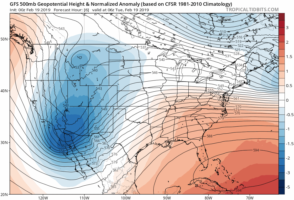
It looks like a safe bet that the heaviest rain will continue moving over the same areas because the upper-levels seem to be on pause for the time being. The above animation shows height anomalies at the 500 millibar level between Tuesday morning and Sunday morning. The trough over the western United States and the ridge over the southwestern Atlantic don’t move much longitudinally through early next week. The southeast is in the unlucky position to get pinched between the trough and the ridge, forcing that highway of precipitation to keep moving over the same areas.

Not everyone will see all of the rain in the forecast. Some communities will only see an inch or two of rain and others could see half a foot or more. It depends on the tracks of thunderstorms and batches of heavy rain as they traverse the area.

Maps: WPC

Rain this heavy could lead to flooding, especially along streams and rivers. Sustained heavy rain could lead to street flooding. I’m sure we’ll see video of someone trying to ford a flooded roadway like they’re the protagonist in Oregon Trail. Here’s a hint for you: you won’t get dysentery, but try to cross a flooded road and you could wash away and die. It’s nearly impossible to judge the depth of water crossing a roadway and you can’t be completely sure that there’s even a road under the water. It can take just a foot of moving water to wash a vehicle downstream.


You can follow me on Twitter or send me an email.

Please consider subscribing to my Patreon. Reader-funded news is more important than ever and your support helps fund engaging, hype-free weather coverage.
 

Author

Dennis Mersereau

I have 15+ of experience providing hype-free weather information for folks across the United States and around the world. In addition to DAMWeather, I also contribute to The Weather Network as a digital writer and weather specialist.

Follow Me
Other Articles
Previous

Flash Flooding Is Likely In Central And Southern California On Thursday

Next

A ‘Significant Tornado and Wind Damage Event’ Is Possible in the South on Saturday


Local ◈ UTC
Facebook | Bluesky
Instagram | Threads | Email
DAMWeather is now ad-free! Everyone benefits from engaging, hype-free weather coverage. Please consider supporting my efforts through Patreon:


Order The Skies Above today!

Bookshop.org || Barnes & Noble
Mountaineers Books || Amazon

My latest book, The Skies Above, is now available!

Did you know a puffy cloud can weigh millions of pounds? Or that every rainbow you see is unique to you?

Our atmosphere is full of spectacular sights that are always within your reach. Glistening layers of fog, gorgeous sunsets, and brilliant meteors flashing through the sky can light up even the calmest day.

The Skies Above, published by Mountaineers Books, is a celebration of what we overlook when we look up. I was thrilled to work with the editors and illustrators at Indelible Editions to share with you the quotidian beauty of our sky.

Order your copy now and learn about the wonders we take for granted every day.

I teamed up with the editors of Outdoor Life magazine to write The Extreme Weather Survival Manual, your guide to surviving and thriving in almost any weather condition. Whether you're an avid outdoorsperson or you enjoy watching the radar from the comfort of your home, you're sure to find helpful tips, advice, and new bits of knowledge in this fascinating book.

You can buy my book today through Amazon.
An error has occurred, which probably means the feed is down. Try again later.
  • 2026 (31)
  • 2025 (49)
  • 2024 (59)
  • 2023 (43)
  • 2022 (57)
  • 2021 (71)
  • 2020 (83)
  • 2019 (88)
  • 2018 (92)
  • 2017 (1)
  • 2016 (4)
  • 2015 (10)

Copyright 2026 — DAMWeather. All rights reserved. Blogsy WordPress Theme