Hurricane Dorian Set To Bring Extreme Winds And Destructive Surge To The Bahamas

Hurricane Dorian continues moving toward the northwestern Bahamas with maximum sustained winds of 150 MPH. While we’re rightfully worried about the southeastern United States, we can’t gloss over the fact that this is an extremely dangerous situation for The Bahamas. A destructive storm surge, extreme winds, and flash flooding from torrential rain will likely cause widespread destruction across the hardest-hit islands.
It’s a testament to the favorable environment surrounding the cyclone and the impressive structure inside the storm itself that Hurricane Dorian has managed to maintain such a great intensity for so long. The storm’s appearance on satellite is straight out of a meteorology textbook. There’s not much more to say—Dorian is about as powerful as they come in this part of the world, and it’s headed toward the northwestern Bahamas.
There’s no distinction between a high-end category four hurricane and a category five hurricane. There is no difference between 150 MPH and 160 MPH winds to a home or business that will experience the winds for an extended period of time. At that point, it’s a matter of how much the debris gets shuffled around.
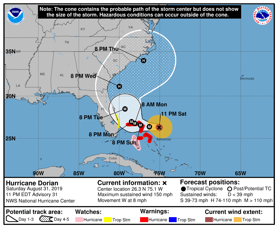
The agency’s forecast track slows the storm to a crawl as it approaches The Bahamas on Sunday and Monday. The storm’s forecast track is so slow—and the forecast points so close together through Monday—that I could not make my own map of the 11:00 PM EDT advisory because it was an unreadable mess, which is why the NHC’s map appears above. (Sorry about that.)
After that, things are still uncertain as the storm tangles with a ridge of high pressure to its north. As we’ve discussed for days and days now, that ridge is keeping Dorian from breaking north and jogging out to sea. The longer that ridge stays put and stays strong, the longer Dorian will move on a westerly course and the greater the threat it poses to the southeastern United States.
Right now, the forecast shows the center of the storm staying offshore. Dorian is a large storm. The center staying a few dozen miles offshore will still generate coastal flooding, strong winds, and heavy rainfall for coastal areas. Any nudge to the west will bring worse conditions closer to land.
Main Points
Extensive Damage Possible In The Bahamas
This is a life-threatening situation for those who live on the islands of Great Abaco and Grand Bahama, including the communities of Marsh Harbour and Freeport. The eyewall will likely scrape across these small islands for many hours. A slow enough speed on the right track could bring some islands the winds of a major hurricane for 24 hours. Twenty-four hours. A full day of this hurricane at full blast would leave only the sturdiest buildings standing.
A storm surge of 10-15 feet above ground level is possible on shorelines exposed to the hurricane’s strongest winds. Torrential rainfall of one to two feet will cause widespread flash flooding in areas with poor drainage. The combination of storm surge and high winds will leave very few areas of safe shelter on the Bahamian islands affected by Dorian’s eyewall.
Florida’s Not Out Of The Woods Yet
The storm’s track is not set in stone. A scenario in which the storm’s
eyewall scrapes the coast—or the storm makes landfall—somewhere in Florida is still very much in play. Even though
current forecasts show the storm curving away from land, a landfall or
land-scraping scenario is still a possibility with only a tiny change in the storm’s forward speed or the environment around it.
If you started hurricane preparations when the cone of uncertainty was pointed right at you, don’t stop now just because the storm is forecast to stay offshore. Things can change and it’s a big storm. Tropical storm conditions are still possible near the coast even if the storm does stay out to sea. A storm this dangerous this close to the coast is nothing to play around with.
Threat Increasing In Georgia And Carolinas
The storm’s curve toward the north puts coastal portions of Georgia, South Carolina, and North Carolina at risk for the whole run of threats, including high winds, storm surge flooding, freshwater flooding from heavy rain, and possibly some tornadoes if the storm makes landfall somewhere. It looks like eastern North Carolina would bear the brunt of a near-land recurve scenario.
It’s A Fluid Situation
I’m posting this so late at night (it’s 12:50 AM as I write this sentence) that the information in this post will probably be outdated pretty soon. This is a long-duration storm and it’s a marathon trying to keep up with every little wiggle and wobble in the storm and in the models. Everyone between Miami and North Carolina’s Outer Banks should be prepared by Sunday night to experience an extended period of hazardous conditions. We’ll know more soon.
[Top Image: College of DuPage | Map: NHC]
Please consider subscribing to my Patreon. Your support helps me write engaging, hype-free weather coverage—no fretting over ad revenue, no chasing viral clicks. Just the weather.

