Skip to content
DAMWeather DAMWeather

The weather can get scary. Reporting on it doesn't have to be.

DAMWeather DAMWeather

The weather can get scary. Reporting on it doesn't have to be.

  • About Me
  • All Bylines
    • Books, Bylines, and Press
    • The Skies Above (Book)
    • Extreme Weather (Book)
    • The Weather Network
    • The Vane
    • Forbes
    • Capital Weather Gang
    • Mental Floss
  • Maps
    • Hurricane Maps
    • Hurricane Names
    • Monthly Tornadoes
    • Tornado Tracks
    • F5/EF-5 Tornadoes
    • SPC High Risk Days
  • GIS Resources
  • Contact Me
    • Bluesky
    • Facebook
    • Instagram
  • wxdam.com

Significant Damaging Winds Are Possible Across Eastern Michigan On Wednesday

By Dennis Mersereau
June 10, 2020 3 Min Read
An intense squall line could sweep through the eastern Great Lakes on Wednesday afternoon, bringing a risk for significant damaging winds, tornadoes, and some reports of large hail.
The Storm Prediction Center (SPC) issued a moderate risk for severe weather—a four out of five on the scale used to measure the severe threat—across eastern Michigan and adjacent portions of Indiana and Ohio. An enhanced risk—a three out of five—radiates out from there to include Cincinnati and Cleveland. The greatest risk with these storms will be widespread damaging wind gusts, with gusts of 70+ MPH possible in the strongest storms.
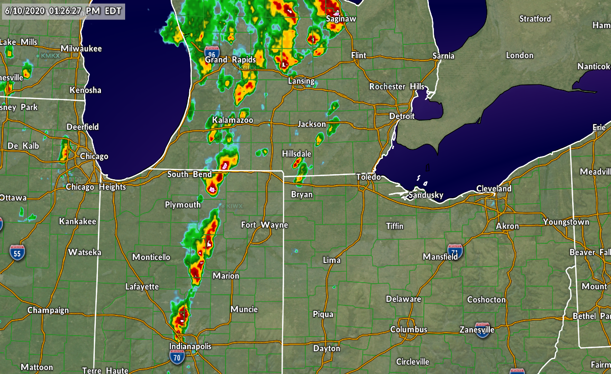
Radar at 12:26 PM CDT on June 10, 2020. Source: WSV3
We’re already seeing strong to severe thunderstorms pop up in Indiana as of this post’s publication. These storms will likely evolve into a squall line that rolls through northwest Ohio and southeastern Michigan through rush hour this evening. It’s this squall line that will pack the greatest risk for damaging winds, some of which could be in excess of 70 MPH. It’s not uncommon to see tornadoes along the leading edge of a squall line.
If you live in areas at risk for storms today, stay aware of watches and warnings and give yourself plenty of time to seek shelter if a storm rolls up on your location. I’ve found the most useful reminder in a situation like this is to avoid rooms in your home that have large trees or limbs that could fall into the building. We always tell people to avoid windows and stay inside, but it’s easy to overlook the potential for falling trees and tree limbs.
It’s unusual to see such a high risk for severe weather in this part of the country. According to the Iowa Environmental Mesonet’s records, the last time Detroit found itself under a moderate risk in a SPC forecast was on November 17, 2013. 
It’s worth noting that the severe threat will also include much of southern Ontario. It’s pretty easy to extrapolate the SPC forecast over the border, bringing a risk for significant wind gusts, tornadoes, and large hail to southwestern Ontario, including Windsor, Sarnia, and London. The threat is lower in the Greater Toronto Area.
If you’re wondering…SPC forecasts don’t stretch beyond the international border for sovereignty reasons. Among other reasons, it could create an international incident if the U.S. government predicts a dire threat for storms on foreign soil if forecasters in that country disagree with their American counterparts.


You can follow me on Twitter or send me an email.

Please consider subscribing to my Patreon. Your support helps me write engaging, hype-free weather coverage—no fretting over ad revenue, no chasing viral clicks. Just the weather.
 

Author

Dennis Mersereau

I have 15+ of experience providing hype-free weather information for folks across the United States and around the world. In addition to DAMWeather, I also contribute to The Weather Network as a digital writer and weather specialist.

Follow Me
Other Articles
Previous

Tropical Storm Conditions Close In On Gulf Coast As Cristobal Approaches Louisiana

Next

Another Weeklong Gloom-Fest Is On Tap For The Mid-Atlantic This Week


Local ◈ UTC
Facebook | Bluesky
Instagram | Threads | Email
DAMWeather is now ad-free! Everyone benefits from engaging, hype-free weather coverage. Please consider supporting my efforts through Patreon:


Order The Skies Above today!

Bookshop.org || Barnes & Noble
Mountaineers Books || Amazon

My latest book, The Skies Above, is now available!

Did you know a puffy cloud can weigh millions of pounds? Or that every rainbow you see is unique to you?

Our atmosphere is full of spectacular sights that are always within your reach. Glistening layers of fog, gorgeous sunsets, and brilliant meteors flashing through the sky can light up even the calmest day.

The Skies Above, published by Mountaineers Books, is a celebration of what we overlook when we look up. I was thrilled to work with the editors and illustrators at Indelible Editions to share with you the quotidian beauty of our sky.

Order your copy now and learn about the wonders we take for granted every day.

I teamed up with the editors of Outdoor Life magazine to write The Extreme Weather Survival Manual, your guide to surviving and thriving in almost any weather condition. Whether you're an avid outdoorsperson or you enjoy watching the radar from the comfort of your home, you're sure to find helpful tips, advice, and new bits of knowledge in this fascinating book.

You can buy my book today through Amazon.
An error has occurred, which probably means the feed is down. Try again later.
  • 2026 (30)
  • 2025 (49)
  • 2024 (59)
  • 2023 (43)
  • 2022 (57)
  • 2021 (71)
  • 2020 (83)
  • 2019 (88)
  • 2018 (92)
  • 2017 (1)
  • 2016 (4)
  • 2015 (10)

Copyright 2026 — DAMWeather. All rights reserved. Blogsy WordPress Theme