Skip to content
DAMWeather DAMWeather

The weather can get scary. Reporting on it doesn't have to be.

DAMWeather DAMWeather

The weather can get scary. Reporting on it doesn't have to be.

  • About Me
  • All Bylines
    • Books, Bylines, and Press
    • The Skies Above (Book)
    • Extreme Weather (Book)
    • The Weather Network
    • The Vane
    • Forbes
    • Capital Weather Gang
    • Mental Floss
  • Maps
    • Hurricane Maps
    • Hurricane Names
    • Monthly Tornadoes
    • Tornado Tracks
    • F5/EF-5 Tornadoes
    • SPC High Risk Days
  • GIS Resources
  • Contact Me
    • Bluesky
    • Facebook
    • Instagram
  • wxdam.com

U.S. Dryness Hits Highest Extent This Century Amid Very Quiet October

By Dennis Mersereau
October 24, 2022 3 Min Read

Hello. 
It’s been a while since I’ve had to write anything around here.
It’s kinda nice, isn’t it?
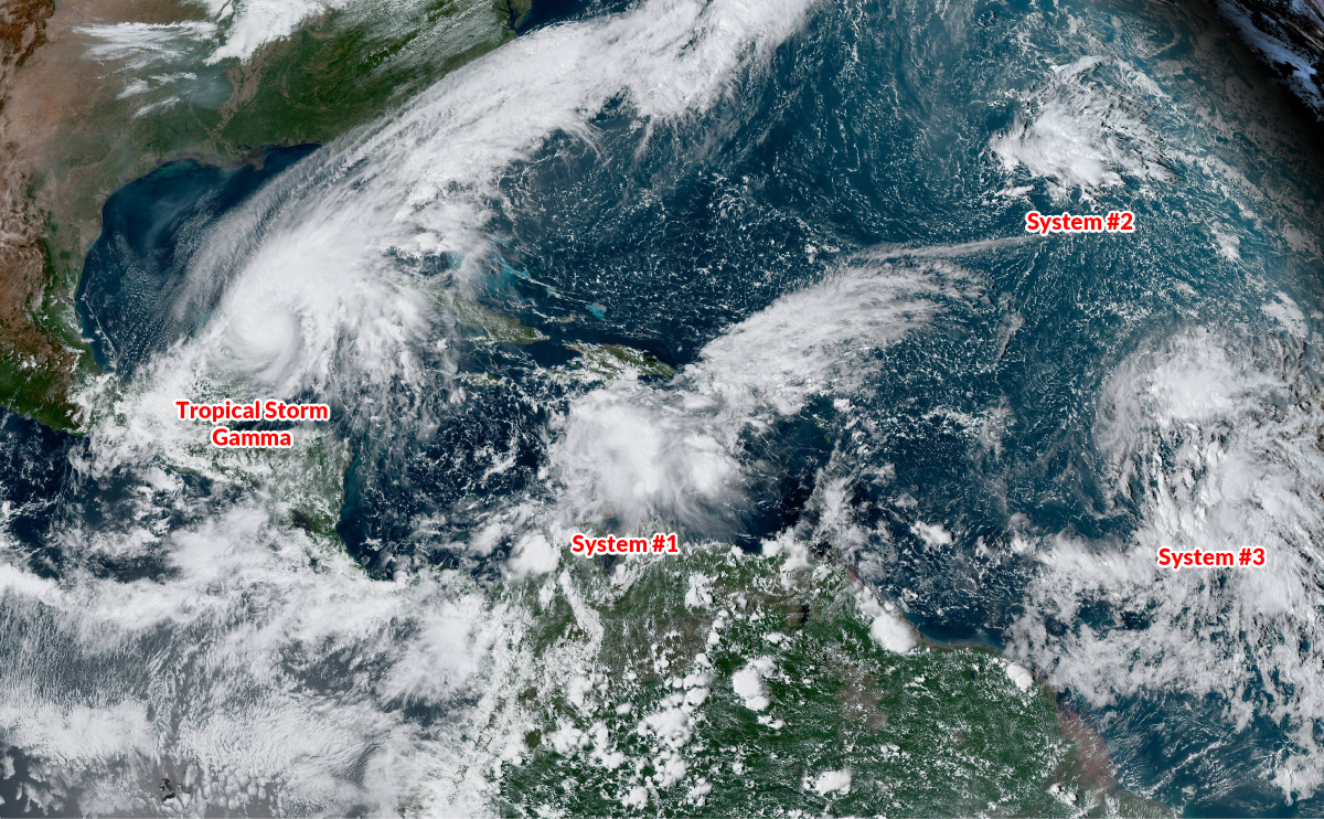
We’ve seen an exceptionally quiet October across the United States this year. Hardly any big storms, no tropical systems making landfall, pretty much no urgent disasters for once. 
The pattern that’s brought us such a serene October left its mark—even if it doesn’t seem like it.

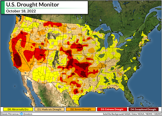
This week’s update of the United States Drought Monitor found that 82.23% of the United States was either “abnormally dry” or mired in full-fledged drought conditions.
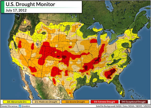
That’s the highest level of dryness measured across the United States since the USDM began keeping track at the beginning of 2000. The previous high-water mark (er, low-water mark?) was 80.76% coverage just over a decade ago on July 17, 2012. 
Here’s what the map looked like on that day ten years ago:

We’re probably going to see some improvement over the next couple of days if current forecasts pan out.
A cold front stretching off a low-pressure system swirling into the Canadian Prairies will spark several opportunities for severe weather heading into the first half of the workweek. Much of the severe threat will target the southern states, bringing a risk for damaging winds, large hail, and possibly even a few tornadoes.
(As an aside, and no surprise here, but it’s also been a very quiet month for severe weather so far. An average October over the past ten years sees about 575 reports of severe weather, while this month has only logged 237 reports through the morning of October 23rd.)

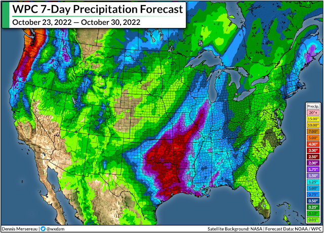
A new low-pressure system will develop along that cold front heading toward the middle of the week, enhancing rainfall totals over parts of the Plains and Midwest. Some areas in parts of Oklahoma, Texas, and Arkansas could even deal with localized flooding.
Farther west, a train of storms rolling in from the northeastern Pacific will bring drenching rains to the Northwest, where they could really use some precipitation after an exceptionally warm and dry fall. The Weather Prediction Center’s seven-day forecast of 5+ inches of rain across much of the Pacific Northwest will put a dent in the ongoing drought across the region.
Elsewhere, though, it’s going to be another unremarkable week in an otherwise unremarkable month.
Enjoy it while it lasts.
[Satellite: NOAA]


You can follow me on Twitter or send me an email.

Please consider subscribing to my Patreon. Your support helps me write engaging, hype-free weather coverage—no fretting over ad revenue, no chasing viral clicks. Just the weather.


Author

Dennis Mersereau

I have 15+ of experience providing hype-free weather information for folks across the United States and around the world. In addition to DAMWeather, I also contribute to The Weather Network as a digital writer and weather specialist.

Follow Me
Other Articles
Previous

Hurricane Ian Hitting The Carolinas With High Winds, Flooding Rains

Next

A Tropical Disturbance Could Bring Foul Weather To The East Coast This Week


Local ◈ UTC
Facebook | Bluesky
Instagram | Threads | Email
DAMWeather is now ad-free! Everyone benefits from engaging, hype-free weather coverage. Please consider supporting my efforts through Patreon:


Order The Skies Above today!

Bookshop.org || Barnes & Noble
Mountaineers Books || Amazon

My latest book, The Skies Above, is now available!

Did you know a puffy cloud can weigh millions of pounds? Or that every rainbow you see is unique to you?

Our atmosphere is full of spectacular sights that are always within your reach. Glistening layers of fog, gorgeous sunsets, and brilliant meteors flashing through the sky can light up even the calmest day.

The Skies Above, published by Mountaineers Books, is a celebration of what we overlook when we look up. I was thrilled to work with the editors and illustrators at Indelible Editions to share with you the quotidian beauty of our sky.

Order your copy now and learn about the wonders we take for granted every day.

I teamed up with the editors of Outdoor Life magazine to write The Extreme Weather Survival Manual, your guide to surviving and thriving in almost any weather condition. Whether you're an avid outdoorsperson or you enjoy watching the radar from the comfort of your home, you're sure to find helpful tips, advice, and new bits of knowledge in this fascinating book.

You can buy my book today through Amazon.
An error has occurred, which probably means the feed is down. Try again later.
  • 2026 (30)
  • 2025 (49)
  • 2024 (59)
  • 2023 (43)
  • 2022 (57)
  • 2021 (71)
  • 2020 (83)
  • 2019 (88)
  • 2018 (92)
  • 2017 (1)
  • 2016 (4)
  • 2015 (10)

Copyright 2026 — DAMWeather. All rights reserved. Blogsy WordPress Theme