Skip to content
DAMWeather DAMWeather

The weather can get scary. Reporting on it doesn't have to be.

DAMWeather DAMWeather

The weather can get scary. Reporting on it doesn't have to be.

  • About Me
  • All Bylines
    • Books, Bylines, and Press
    • The Skies Above (Book)
    • Extreme Weather (Book)
    • The Weather Network
    • The Vane
    • Forbes
    • Capital Weather Gang
    • Mental Floss
  • Maps
    • Hurricane Maps
    • Hurricane Names
    • Monthly Tornadoes
    • Tornado Tracks
    • F5/EF-5 Tornadoes
    • SPC High Risk Days
  • GIS Resources
  • Contact Me
    • Bluesky
    • Facebook
    • Instagram
  • wxdam.com

Central U.S. Faces First ‘High’ Risk Severe Weather Day In Years

By Dennis Mersereau
March 31, 2023 2 Min Read

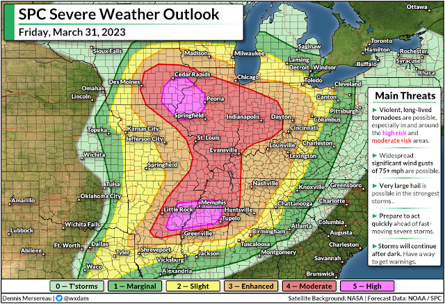
The Storm Prediction Center (SPC) expects a widespread and significant severe weather outbreak across much of the central United States on Friday, including the potential for “violent, long-lived tornadoes,” as well as destructive wind gusts of 75+ mph and very large hail in the strongest storms.
This is the first high risk issued by the SPC since March 25, 2021, a day that saw multiple violent tornadoes tear across Alabama and Georgia. This also appears to be the first ‘double’ high risk—with two distinct bullseyes—in over a decade.
Friday’s upgrade to high risk is tornado-driven, according to SPC forecasters, with a better-than-even chance of violent, long-lived tornadoes in eastern Iowa and northwestern Illinois—including Cedar Rapids, Davenport, and Peoria—as well as a swath of the Mid-South, centered around the Memphis metro area.
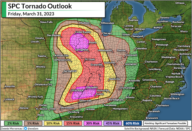
Areas under the high risk are just where dynamics are approaching peak favorability for significant tornadoes. We still have a very large swath of the country under a moderate risk, including almost the entire state of Illinois, most of Indiana, and large portions of every state bordering the Mississippi River down to Greenville.
Communities in and around the moderate and enhanced risk areas could also see widespread destructive wind gusts, significant tornadoes, and large hail. Many major cities and transportation hubs are included in this sprawling threat for severe weather.
“Particularly Dangerous Situation” (PDS) tornado watches were issued for most of the high risk and moderate risk areas by midday on Friday, with the threat growing through the afternoon hours and spreading east into the overnight.
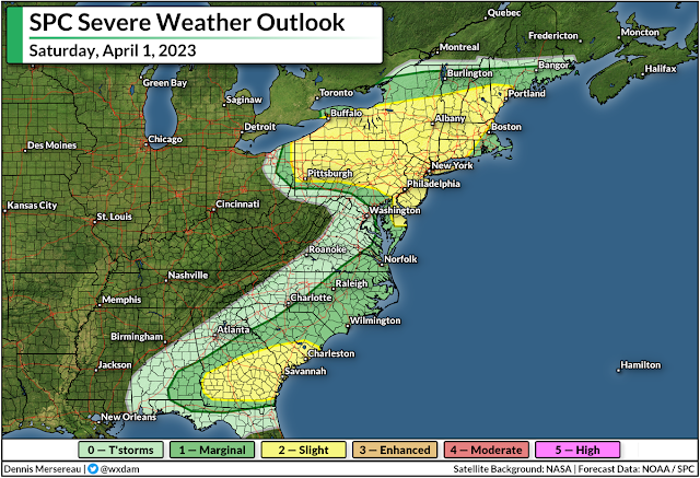
This wide-ranging severe weather outbreak will push east Friday night into early Saturday morning as the powerful Colorado low responsible for this outbreak tracks across the Great Lakes into Ontario.
Another round of severe weather is likely on Saturday up and down the East Coast, with damaging winds and isolated tornadoes possible from near the Quebec border down through the Florida Panhandle.
Make sure you’ve got a way to get warnings and seek safe shelter, and give your friends and family a heads-up if they’re in the area.


You can follow me on Facebook, Mastodon, Twitter, Instagram, or send me an email.

Please consider subscribing to my Patreon. Your support helps me write engaging, hype-free weather coverage—no fretting over ad revenue, no chasing viral clicks. Just the weather.


Author

Dennis Mersereau

I have 15+ of experience providing hype-free weather information for folks across the United States and around the world. In addition to DAMWeather, I also contribute to The Weather Network as a digital writer and weather specialist.

Follow Me
Other Articles
Previous

Widespread Severe Weather Expected Friday Across The Central U.S.

Next

Another Round Of Significant Severe Weather Is Likely On Tuesday


Local ◈ UTC
Facebook | Bluesky
Instagram | Threads | Email
DAMWeather is now ad-free! Everyone benefits from engaging, hype-free weather coverage. Please consider supporting my efforts through Patreon:


Order The Skies Above today!

Bookshop.org || Barnes & Noble
Mountaineers Books || Amazon

My latest book, The Skies Above, is now available!

Did you know a puffy cloud can weigh millions of pounds? Or that every rainbow you see is unique to you?

Our atmosphere is full of spectacular sights that are always within your reach. Glistening layers of fog, gorgeous sunsets, and brilliant meteors flashing through the sky can light up even the calmest day.

The Skies Above, published by Mountaineers Books, is a celebration of what we overlook when we look up. I was thrilled to work with the editors and illustrators at Indelible Editions to share with you the quotidian beauty of our sky.

Order your copy now and learn about the wonders we take for granted every day.

I teamed up with the editors of Outdoor Life magazine to write The Extreme Weather Survival Manual, your guide to surviving and thriving in almost any weather condition. Whether you're an avid outdoorsperson or you enjoy watching the radar from the comfort of your home, you're sure to find helpful tips, advice, and new bits of knowledge in this fascinating book.

You can buy my book today through Amazon.
An error has occurred, which probably means the feed is down. Try again later.
  • 2026 (30)
  • 2025 (49)
  • 2024 (59)
  • 2023 (43)
  • 2022 (57)
  • 2021 (71)
  • 2020 (83)
  • 2019 (88)
  • 2018 (92)
  • 2017 (1)
  • 2016 (4)
  • 2015 (10)

Copyright 2026 — DAMWeather. All rights reserved. Blogsy WordPress Theme