High-impact heat set to build over much of the U.S. through mid-June
The jet stream is moving to Canada—and you might also want to head north after seeing the temperatures on the way over the next week or longer.
A long-duration spell of warmer-than-normal temperatures will bathe the eastern half of the United States through the middle of the month as a ridge takes hold over the region.
Not only will this pattern crank up the heat, but it may finally shut off the Ferris wheel of severe thunderstorm outbreaks we’ve endured since early spring.
The Temperatures

It’s already plenty hot across the Plains and the southeastern corner of the country, where temperatures on Wednesday easily climbed into the 90s for many locations.
We’ll see that heat spread north and east as the ridge builds into place through the weekend, with daytime highs pushing into the upper 80s and lower to mid-90s by Sunday.
The warmth isn’t going anywhere in a hurry, with highs in the 90s likely across the eastern seaboard all through next week and possibly into the following weekend.
Here’s a look at the National Weather Service’s forecast high temperatures on Monday, June 17…

…and here’s a look at Tuesday’s predicted high temperatures:

The Setup
A jet stream parked over the northern tier of the United States has driven the drumbeat of severe weather over the past couple of months. One low-pressure system after another cresting the Rockies and roaring through the central U.S. has fueled a healthy thunderstorm season.
We just experienced our second-most tornadic April on record, and the Storm Prediction Center announced Tuesday that last month was one of the most severe Mays on record.
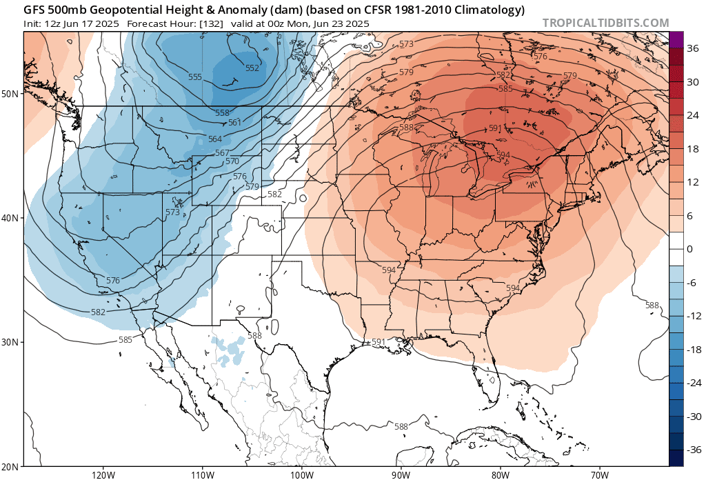 |
| Image: Tropical Tidbits |
The jet stream tends to migrate north as summer settles in, which helps push severe weather farther to the north—while also letting the heat build to the south.
Models are consistently showing ridges of high pressure parked over the eastern half of the United States through the middle of the month. Air sinks beneath ridges, warming up as it descends toward the ground.
A persistent ridging pattern will keep temperatures much warmer than normal for a week or longer, which is no small thing considering average temperatures in the latter half of June are pretty warm to begin with.
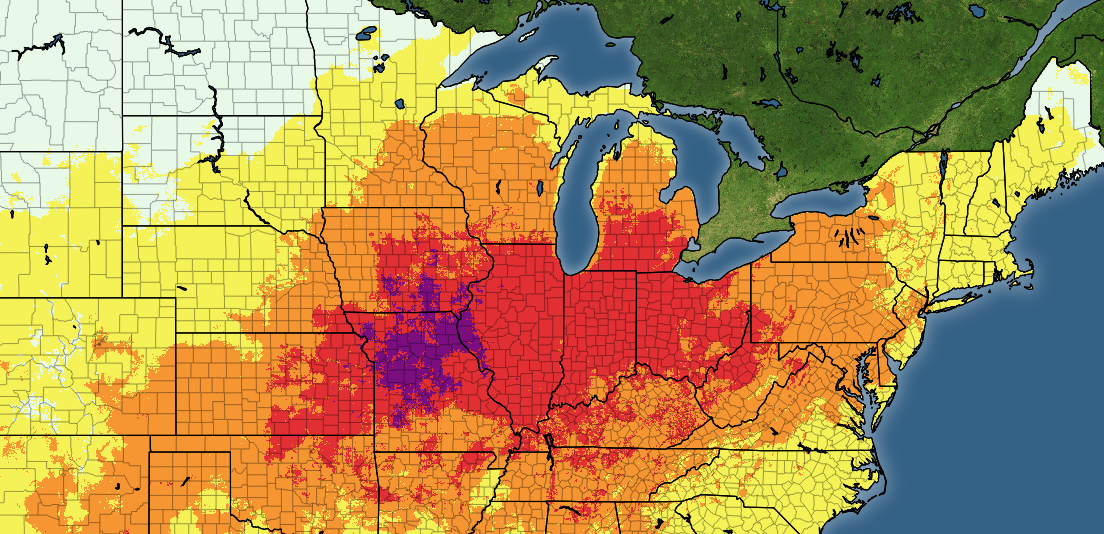
Heat Impacts

This is the first large-scale test of the National Weather Service’s new HeatRisk product, which measures the potential impact of high heat on certain regions. HeatRisk takes into consideration factors like:
- The time of year
- How far above normal temperatures are for that time of year
- How long the unusual heat will stick around
- Temperatures reaching thresholds known to cause heat-related illnesses
Urban areas are regions farther to the north are likely to experience higher risk from heat than communities down south. Access to cooling and your body’s physical acclimation to heat plays a significant role in heat impacts. A 90°F and humid day is far different for folks living in Mobile, Alabama, than it is for a lifelong resident of Detroit, Michigan.

The potential for major to extreme heat impacts light up the board across the central and northern U.S. over the next week given the latest NWS temperature forecasts. The greatest risk focuses on the Midwest by the end of the weekend, pushing toward the Great Lakes by the beginning of next week.
The compounding effects of hot, humid days and stuffy, muggy nights will take a toll on vulnerable people—especially those without reliable access to air conditioning. Take care if hot temperatures are on the way to your area. It’s easier to succumb to heat exhaustion or worse than you think, even for someone who’s otherwise healthy.


