Hurricane Florence Is a Slow-Motion Disaster With Historic Rains, Deadly Storm Surge

Hurricane Florence is making a slow-motion landfall along the North Carolina coast this evening. The storm is moving painfully slow—just 5 MPH as of 11:00 PM Thursday. The storm’s creeping track toward North Carolina and South Carolina will expose a vast swath of land to an extended period of intense winds, historic rains, and exacerbate the life-threatening storm surge already inundating the coast.
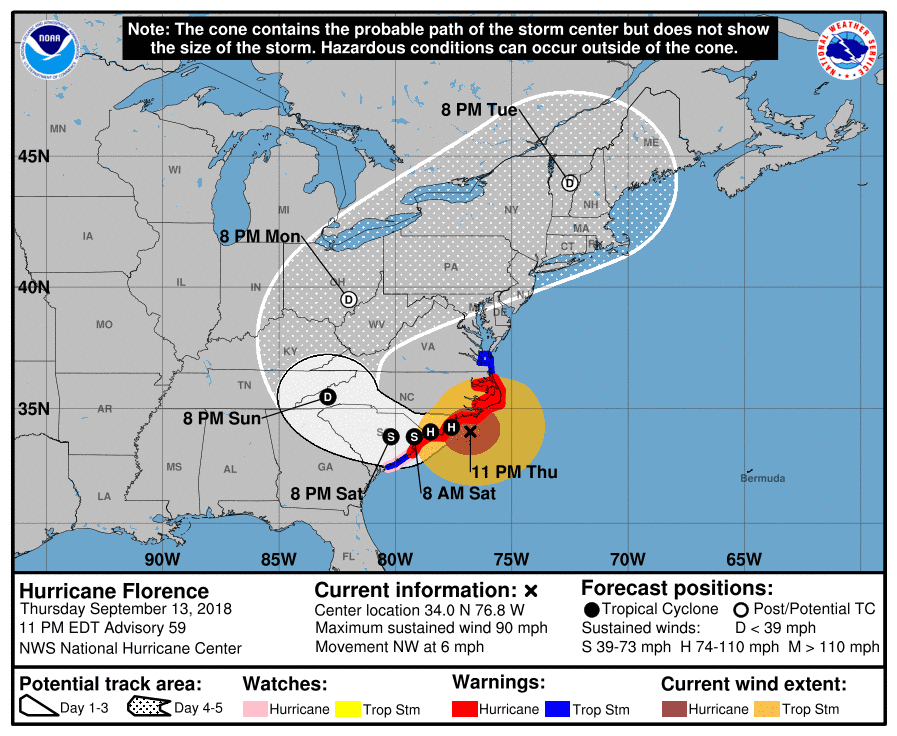
The National Hurricane Center expects Florence to eventually make landfall near Wilmington, North Carolina, during the day on Friday. It will begin pushing inland through the weekend before a trough picks it up and causes it to race toward the Northeast early next week.
Hurricane Florence is going to be a long-duration event, and we can’t stress the hazard posed by water with this storm. Most fatalities in a landfalling tropical cyclone are caused by drowning. Freshwater flooding from prolonged heavy rain and a storm surge at the coast will likely cause damage from this hurricane to rise into the billions of dollars. This was a well-warned event, and hopefully most folks in the path of flooding and surge were able to get out before the storm made escape all but impossible.
RAIN

The latest forecast from NOAA’s Weather Prediction Center shows an eye-popping swath of 20″+ of rain expected by the end of the storm. This would exceed the devastating rainfall totals seen in 1999’s Hurricane Floyd and the remnants of Hurricane Matthew in 2016. This kind of rain will lead to unprecedented flooding in this part of the Carolinas. I’ve never seen a rainfall map like this before outside of Texas during Hurricane Harvey last year.
Adding insult to injury, the WPC notes that some areas in that 20″+ swath may see final totals up near 40″. That’s more than three feet of rain. That would make this the wettest tropical cyclone in the southeastern United States and one of the wettest in the country’s history. Rainfall will taper off—a relative term, in this case—farther inland, but totals of 6-12 inches (higher in some spots) will still lead to flash flooding as far inland and north as the Virginia mountains.
Forecasts of excessive rain are already verifying where Florence’s rain shield is ashore. A rain gauge near Morehead City has reported a foot of rain since the storm started earlier on Thursday. Given the storm’s slow movement, that total will easily double by this time tomorrow.
STORM SURGE
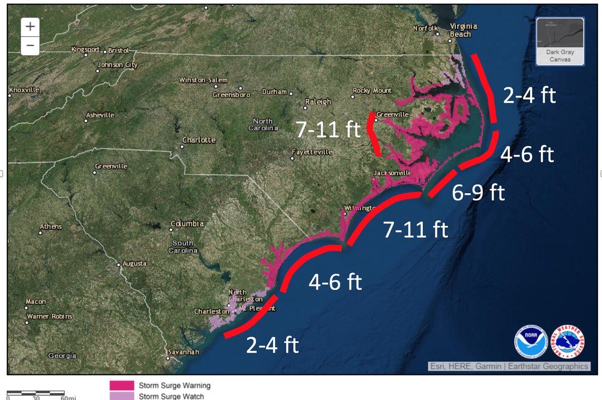 |
| Expected storm surge from Hurricane Florence. SOURCE: National Hurricane Center |
It’s not just the rain causing life-threatening flooding. A storm surge of 10 feet above normal water levels was reported at the Cherry Branch Ferry Terminal, located near the mouth of the Neuse River southeast of New Bern, North Carolina. The storm surge along the coast in North Carolina is enough to inundate the first level of homes and businesses near the shore. This will kill people who elected to stay behind and can’t evacuate to a higher level or the roof.
The surge will continue to build along north- and east-facing coasts as the storm nears landfall. This was one of the problems with focusing on Florence’s maximum wind speeds. As I wrote yesterday, the storm started translating its energy into expanding the wind field rather than focusing it all in an intense sting of winds in the eyewall. Large, strong storms lead to devastating storm surges. We’ve seen it time and time again in past storms, and it’s playing out right now in Florence.
WIND

While flooding is the headline story from this hurricane, the wind can’t be ignored. Winds are already gusting around 100 MPH as the core of the storm starts dragging over land. A 105 MPH wind gust was reported at Fort Macon, N.C., just after 8:00 PM on Thursday. Between 9:00 PM and 10:30 PM, Fort Macon saw another gust up to 99 MPH, a 96 MPH gust occurred at Cape Lookout, and the NWS office in Newport, N.C., saw an 82 MPH gust.
The wind is already causing severe and widespread power outages. This trend will continue down the coast and inland as the ground softens due to heavy rain and flooding. Millions of people will spend a long time in the dark because of this storm. Downed trees will also likely block roadways, damage homes, and potentially crush cars.
There’s some discussion about how folks in harm’s way reacted to the
storm “only” packing category two winds as it approaches land. Even
without the extreme winds, the biggest story with
Florence was always going to be the water. The categories of the
Saffir-Simpson Scale only apply to winds. It says nothing of the storm
surge or rain that accompanies the storm. Many of the most destructive
storms we’ve seen in the past couple of decades packed hazards far
greater than their category.
Even so, it’s easy to lose
sight of how much wind damage can be caused by a low-end hurricane.
Severe thunderstorms are warned for 60 MPH wind gusts and many of the
memorable derechos of years past had maximum winds of 80 to 90 MPH.
Those winds only lasted for a few minutes. These are lasting for many
hours without relenting.

