A Coastal Storm Could Bring Freezing Rain To New England On Monday
A nor’easter that brought heavy rain, high winds, and coastal flooding to the Carolinas this weekend could produce a period of freezing rain in New England early next week. The latest forecasts don’t call for a full-fledged ice storm, but even a thin crust of ice is dangerous on exposed surfaces.
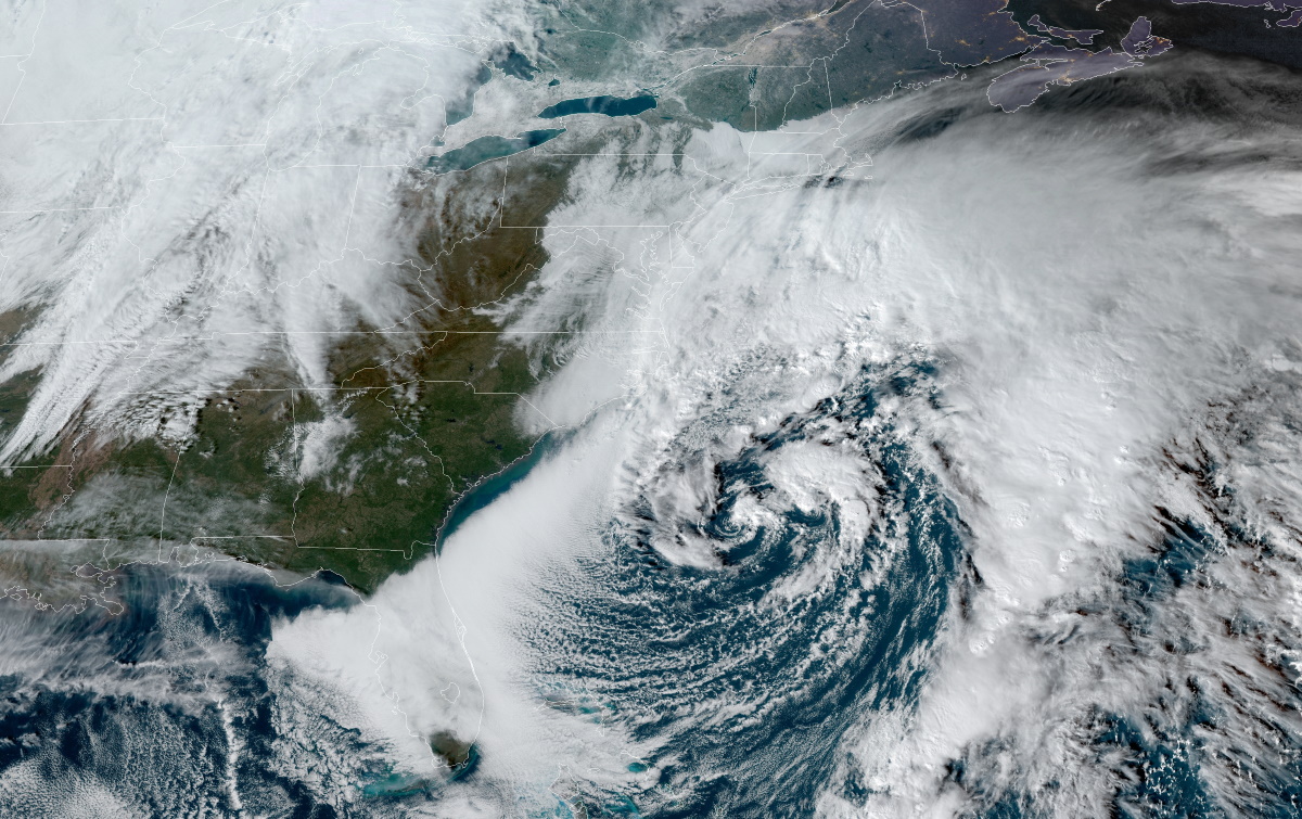
The storm is quite the looker on satellite imagery today. You can clearly see the low-pressure system’s center of circulation as the system wraps up and moves north. Sunday’s 1:00 PM EST analysis from the Weather Prediction Center put the storm’s minimum central pressure around 994 mb, and its pressure should hold steady or drop a little as it moves toward Atlantic Canada over the next couple of days.
Carolinas Rain And Wind
This is the same system responsible for all the cloudy, drizzly, rainy weather we’ve seen in the southeast for the past couple of days. The system managed to grow more organized once it left the coast, which is good news for folks in the eastern Carolinas, since double-digit rainfall totals occurred just a few dozen miles off the coast near the NC/SC border.
A cold rain is miserable enough, but this storm was downright windy, too. Winds gusted as high as 36 MPH in Greensboro, N.C., and gusts hit 60 MPH on the state’s Outer Banks. The wind and waves led to coastal flooding in areas like Charleston; the water at the Charleston Harbor tide gauge came within a quarter of an inch of major flood stage at high tide on Sunday morning. The outer banks also saw significant storm surge flooding and beach erosion, with some roads in Rodanthe, N.C., completely covered by water and sand early Sunday.
Potential Freezing Rain In New England

The storm is picking up speed as it moves away from the Carolinas, eventually making a wide hook into Atlantic Canada over the next couple of days. The biggest threat from this storm is freezing rain, which could coat most of New England and parts of Quebec and New Brunswick through Tuesday. Winter weather advisories are in effect for most of New England in anticipation of freezing rain on Monday and Monday night.
The best chance for a glaze of ice near the coast will exist on Monday morning before temperature jut above freezing and it all turns to a cold, miserable rain. A greater chance for freezing rain exists inland, where temperatures near the surface should stay at or below freezing for the duration of the storm.
Steady freezing rain will begin in interior New England on Monday evening and continue through the night before changing over to snow. The Weather Prediction Center’s most likely ice accretion forecast shows the potential for 0.10″ of ice from freezing rain, which is enough to leave a solid, snappable crust on exposed surfaces. This won’t rise to the level of a full-fledged ice storm, but even a thin glaze of ice is dangerous for motorists and pedestrians, especially when it’s dark and you can’t see the slippery surfaces.
Why Ice Instead Of Snow?
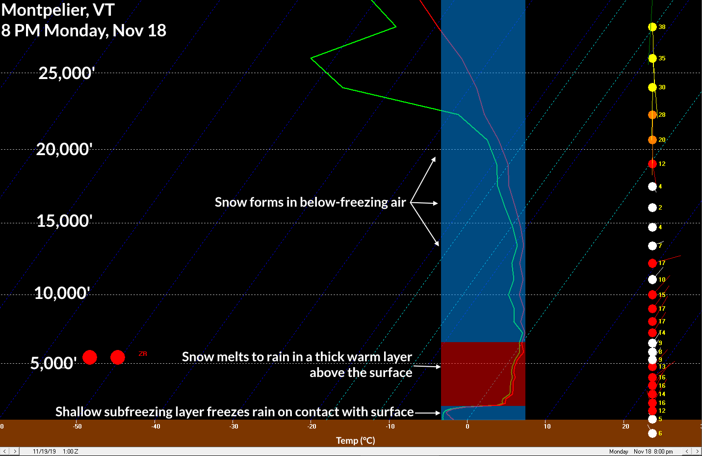
Why will the storm start as freezing rain even though temperatures are below freezing at the surface? As the storm draws closer, it’ll begin to wrap around a layer of warm air a few thousand feet above the surface. You can see this pretty well in the weather models.
 |
| BUFKIT |
The above image is from a program called BUFKIT, which uses model data to simulate the SKEW-T charts that meteorologists use to plot out upper-air data from weather balloons. A SKEW-T chart shows the temperature, moisture, and wind speed through a column of the atmosphere. It’s like looking at a cross-section with all the data plotted out for you.
The red line on the right traces the temperature through the atmosphere, while the green line traces the dew point through the atmosphere. The altitude on this chart is measured in feet above ground level. This particular graphic shows the GFS model’s view of the atmosphere over Montpelier, Vermont, at 8:00 PM EST on Monday. I’ve highlighted the layers of the atmosphere that are above- and below-freezing.
If this model scenario pans out, the surface temperature in Montpelier at 8 PM on Monday would be about 28°F. However, the air temperature about 2,000 feet above ground level peaks at about 38°F.
Snow will fall until it reaches about 6,000 feet above ground level, at which point it’ll start to meet air that’s above freezing. Any snowflakes that fall into the thick layer of above-freezing air above Montpelier will completely melt into a liquid raindrop. The raindrop will begin to cool below freezing once it enters that shallow layer of 28°F air right at the surface, freezing on contact with any exposed surfaces.
This nose of warm air across interior New England will slowly erode through Monday night until the entire atmosphere is below freezing, at which point the freezing rain (and possibly some sleet) changes over to all snow. The National Weather Service expects that a couple of inches of snow will fall in northern Vermont and New Hampshire, with up to five inches of snow possible near the Canadian border in northern Maine.
[Top Image: NOAA]
Please consider subscribing to my Patreon. Your support helps me write engaging, hype-free weather coverage—no fretting over ad revenue, no chasing viral clicks. Just the weather.

