A Significant Severe Weather Outbreak Is Possible Across The Southeast On Easter Sunday
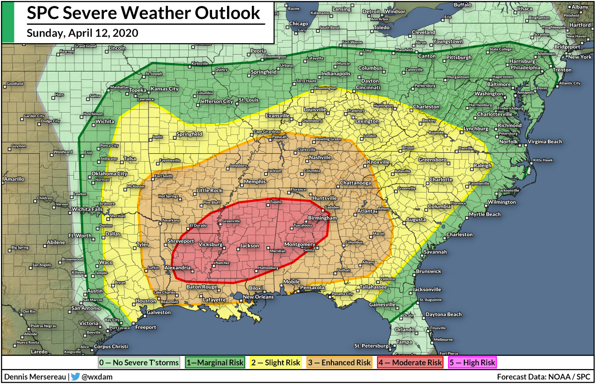
A multi-day severe weather event will peak on Sunday with the possibility of a significant severe weather outbreak across the heart of the southeastern states. A moderate risk for severe weather is in effect on Sunday for parts of Louisiana, Mississippi, and Alabama, with the threat for dangerous storms radiating out from there to include communities from eastern Texas to eastern Georgia. Conditions appear favorable for storms to support strong, long-track tornadoes, as well as widespread damaging winds and some instances of very large hail.
The Setup
 |
| Source: Tropical Tidbits |
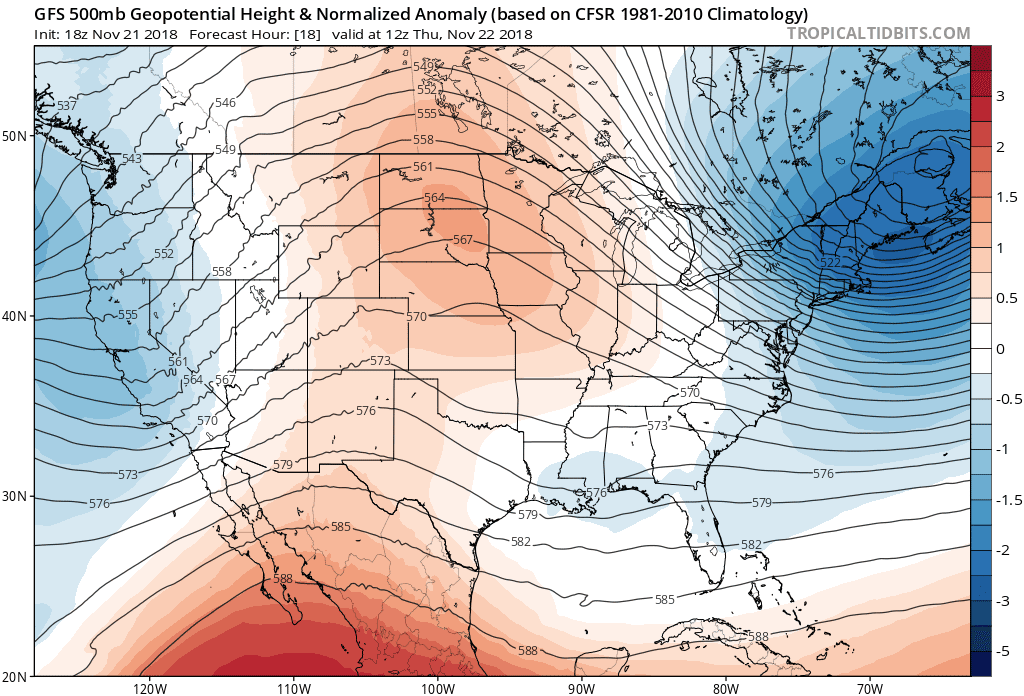
This weekend’s severe weather setup has its roots in the same upper-level low that brought so much rain and snow to California over the last week. Parts of California have seen more than half a foot of rain at lower elevations and many feet of snow at higher elevations as a result of the stalled system.
California’s storm got pinned over the West Coast by a large ridge of high pressure over the central United States. A trough dipping south out of Canada pushed the ridge out of the way, unblocking the upper-level low and allowing it to move east across the United States. The trough generated a low-pressure system at the surface over the southern Plains, setting the stage for the severe weather.
Sunday’s Outlook
All indications point to a large-scale and potentially significant severe weather outbreak on Sunday. A moderate risk for severe thunderstorms—a 4 out of 5 on the SPC’s ascending scale—exists from central Louisiana to central Alabama, with an enhanced risk (3/5) covering a huge area from the northern Gulf Coast to the Ohio River.
Storms will start across the western risk areas on Sunday morning, progressing eastward through the afternoon and evening hours. Severe thunderstorms will reach Georgia and the Carolinas overnight on Sunday into Monday.
Tornadoes
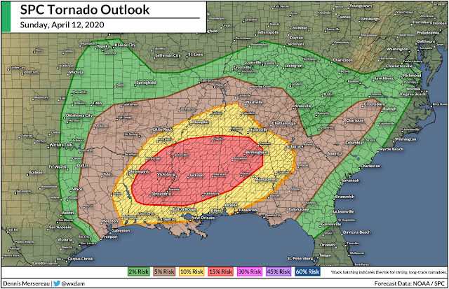
The banner headline on Sunday is the tornado threat.
The SPC’s outlook on Saturday afternoon painted a 15% risk for significant tornadoes across the moderate risk areas, with a 10% risk radiating out from there to include New Orleans, Mobile, Atlanta, and Memphis. 10-15% doesn’t seem like much, but it’s a relatively large risk considering we’re talking about tornadoes.
This is a common setup for the middle of April. We see this type of threat at least once a year…often more than that. Tornado safety is embedded in the culture around these parts.
Not every storm will produce a tornado. Not every tornado will be enormous, nor will every tornado incur a high rating on the Enhanced Fujita Scale. But the setup on Sunday looks similar to the kind of days that produce significant tornadoes. That should give you some sense of how serious the situation could be if the event lives up to its full potential.
 |
| Source: Tropical Tidbits |
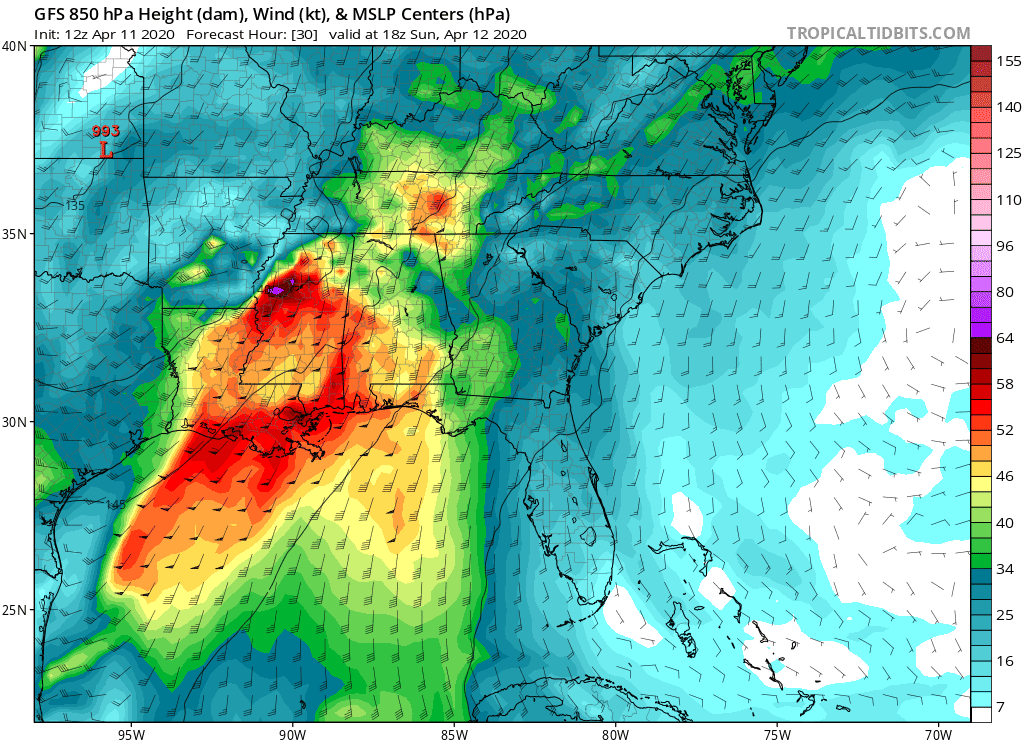
If storms are able to develop during the period when wind shear is just right, they’ll have plenty of “spin” to work with throughout the lower levels of the atmosphere. The graphic above shows the winds at 850 mb (about 5,000-ish feet). The area of intense southerly winds over the southeastern states is known as a low-level jet; winds in the lower levels of the atmosphere are ripping along at 50+ knots, gradually veering toward the southwest and west as you get higher up toward the jet stream. This twisting of the winds will allow strong thunderstorms to develop into supercells capable of producing strong tornadoes, large hail, and damaging winds.
Hail

As you’d expect with a significant severe weather setup, hail is going to be a big deal. The strongest storms will be capable of producing hail the size of golf balls or larger, which is big enough to total a car and cause serious damage to homes.
This kind of hail will easily shatter a window, especially when it’s blowing around in wind gusts of 60+ MPH. Even “just” a severe thunderstorm warning is reason enough to get away from windows and take cover. Shattering glass from windows and skylights is dangerous enough without all the other threats thrown in the mix.
Wind

The threat for damaging winds is always the most widespread risk on a severe weather day. Wind gusts of 60+ MPH are enough to bring down trees and power lines, leading to widespread power outages. Trees are vulnerable to snapping in high winds right now because they’re in full leaf and this is the first real stress they’ve experienced since last summer. Stay mindful of limbs and large trees that loom over your home and avoid those rooms when a storm is on its way.
Flooding
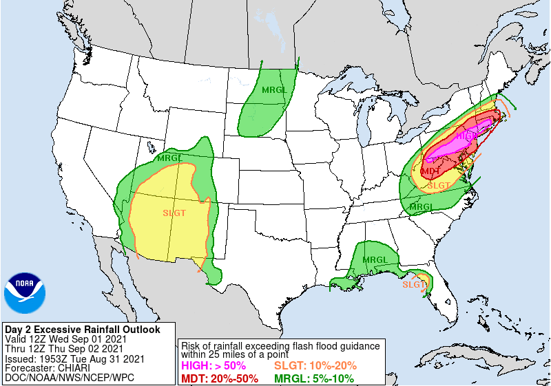
Don’t sleep on the risk for flash flooding from heavy rain. Several inches of rain are likely whether or not you experience any severe weather. The Weather Prediction Center’s excessive rainfall outlook paints a moderate risk for flash flooding across a large portion of the southeast on Sunday. Natural waterways will quickly overflow their banks during a heavy thunderstorm, and street flooding is a high likelihood as well.
Monday

The low-pressure system will reach the Great Lakes by Monday and trigger one last round of severe thunderstorms over the eastern states before the cold front moves out over the ocean. The SPC’s latest forecast shows a risk for severe storms from northern Florida to upstate New York, with the greatest risk existing along the coastal Carolinas.
Many of Monday’s storms will occur early in the morning when folks are asleep, so make sure you have a way to receive severe weather warnings that’ll wake you up.
Words of Caution
1) The caveats.
The best case scenario is that only a handful of severe thunderstorms form and meteorologists get hollered at for a week because people got upset and scared “for nothing.” We see a few notable setups under-deliver every year. Last year was the infamous high risk over central Oklahoma; conditions looked primed for a horrendous tornado outbreak, but storms had trouble forming in the area where all the parameters for tornadic development were maxed-out.
Historic tornado outbreaks are rare and memorable for a reason. Big severe weather outbreaks have so many failure points that it’s hard for a big one to live up to its full potential. Supercells can quickly merge into a squall line and rob each other of the dynamics they need to produce tornadoes. Showers and storms earlier in the day can muddle the instability and stunt storm development later on when the wind shear is most favorable for supercells to develop.
While it’s hard for a day to achieve its potential, never bet on a bust. If there’s a risk, assume it’s going to happen and plan accordingly. It’s great if it doesn’t. There’s still a lot to learn about meteorology. But it’s a testament to how far the science has come that forecasters can raise the alarm days ahead of time when some of our immediate family members remember the days when you had to see the tornado to know one was possible.
2) Know the jargon.
You’ll see a lot of insidery terms and model images flying around on social media tonight and tomorrow, often without explanation. Not all meteorologists gear their posts and language toward the general public; lots of meteorologists use Twitter to talk to other meteorologists. However, some pages, especially on Facebook, like to post this stuff because it gets your Uncle Filbert to share it with all his friends.
 |
| Source: Pivotal Weather |
One of the most commonly shared images these days is “updraft helicity.” This graphic appears to show tornado-like tracks moving across the at-risk areas. Updraft helicity measures the strength of the rotating updrafts in thunderstorms simulated by the model.
People who aren’t familiar with these graphics tend to fixate on the exact track of the paths—not unlike spaghetti model charts during hurricane season—and go “whew, I’m in the clear” or “oh no, we’re doomed.” Those updraft helicity charts are best used to see where thunderstorms have the best opportunity to turn into supercells that could produce tornadoes. The stronger the signal, the more favorable the environment. It’s never a good idea to focus on the specific tracks.
 |
| Source: Pivotal Weather |
Another routine visitor during tornado season is the Significant Tornado Parameter (STP). Meteorologists have developed a ton of indices to boil down lots of different dynamics into one bite-sized number to quickly identify areas of hazardous conditions. The STP is one of the parameters that got traction because it’s relatively easy to talk about with folks who aren’t weather buffs.
The STP is an algorithm that combines different measures of instability and wind shear to highlight how favorable an environment is to produce significant (EF-2+) tornadoes. It’s not perfect, but it’s good for a quick evaluation of where things could get ugly if storms can fully engage with the environment around them.
You might also see meteorologists and enthusiasts talking about “CAMs,” which became one of those must-use buzzwords a few years ago for people who need to prove their worth (or make themselves sound smart, but that’s another issue) on social media. A CAM is a convection-allowing model, such as the NAM or the HRRR. These models allow the simulation of thunderstorms, which is helpful during severe weather events. Global models like the GFS and European can miss the small-scale features that help meteorologists fine-tune their forecasts. Meteorologists can use models like the NAM or the HRRR to help forecast the placement, motion, and type of severe thunderstorms up to a day in advance.
Safety Steps
1) Stay. Home.
The potential for a tornado outbreak during a pandemic is an unusual situation, and it’s one that meteorologists and emergency managers have been dreading since the COVID-19 crisis started.
Most states are under some version of stay-at-home orders or guidance right now. Theoretically, people shouldn’t be gathering at church on Easter Sunday or piling into homes for a big dinner on Sunday evening. If everyone is mindful of the safety guidelines, folks staying home instead of gathering in large crowds should limit the potential for mass casualties that would come from a tornado outbreak on a normal Easter Sunday.
That’s how things are supposed to be.
In practice, though, we have widespread reports of churches intentionally rebelling against stay-at-home orders and people ignoring the orders to visit family and friends under the misguided illusion that they can’t get sick or that they’re not carrying the virus. That’s a horrible idea given that we’re approaching the apparent peak of COVID-19 infections across the country, but it’s an exceptionally bad idea on a day when dangerous severe weather is possible.
Many folks live in homes that are susceptible to high winds and would be incur serious damage or complete destruction in even a low-rated tornado. I wrote about this conundrum a few weeks ago. What do folks do when they rely on community shelters that might not even be open? There aren’t many good answers, but it’s best to think about it now rather than when the tornado warning is issued.
2) Don’t look for the tornadoes.
Seriously. The terrain in the southeast absolutely sucks for spotting tornadoes. In most areas, all you’ll see are dark clouds scraping the tops of the trees until the tornado is right on top of you. I know lots of people still like to see the tornado coming before they’ll dive into their basements/closet/bathroom/whatever. Not only does the terrain here obscure tornadoes until it’s too late, but the atmosphere is so moist in the southeast that most tornadoes are rain-wrapped, making them impossible to spot until it’s too late.
If there’s a tornado warning, trust the threat is there and seek shelter like you saw it yourself.
3) Wear shoes, jeans, and a helmet.
If your home is damaged by a tornado, strong winds, or even a serious pelting of large hail, you’ll have to walk through a myriad of sharp debris to get out and assess the damage. You’ll need to wear shoes and jeans to walk across debris like broken glasses, jagged pieces of wood, electrical wires, pipes, and nails.
Also, it may look dorky, but wearing a bicycle or motorcycle helmet while you’re sheltering from a tornado could save your life. It’s unpleasant to talk about, but a leading cause of death during a tornado is a fatal blow to the head by flying debris. A helmet can’t stop you from getting hurt if the worst happens, but it can keep you alive.
4) Watch the radar and listen for warnings.
This is the kind of setup that will likely produce long-lived storms. It’s likely that folks in the path of the most serious storms will be able to watch them on the news for an hour or more before they approach their communities. Be proactive. Stay aware. And please make sure the emergency alerts in your smartphone’s settings are still activated for tornado warnings.
Please consider subscribing to my Patreon. Your support helps me write engaging, hype-free weather coverage—no fretting over ad revenue, no chasing viral clicks. Just the weather.

