Here’s The Latest On The Two Storms Heading Toward The Gulf This Weekend
The latest forecasts from the National Hurricane Center show the potential for two different tropical cyclones in the Gulf of Mexico next week. If their predictions come to pass, the Gulf Coast could see two landfalls within 24 hours of one another. While two storms in the Gulf at once isn’t completely without precedent, it’s rare because it’s an extremely difficult feat for the atmosphere to achieve.
Dispelling The Myths
Let’s get this out of the way right off the bat.
There is no such thing as a “double hurricane.”
There is no such thing as a “megastorm” or a “superstorm.”
These two storms won’t multiply their strength if they merge.
The two storms wouldn’t comically rotate around one another like they’re doing an oceanic tango—but more on that farther down the article.
This kind of a situation is like catnip for news outlets that couldn’t care less about the weather until there’s something they can hype for clicks and ratings. It’s a crying shame that they can’t cover weather for weather’s sake, but that’s the way it is and we’re all worse off for it.
But I digress.
Tropical Storm Laura — The Atlantic One

Tropical Storm Laura is the system in the northeast corner of the Caribbean right now. The storm got upgraded to a tropical storm today but it’s still struggling, though not as much as last night. The center of the storm is very close to St. Kitts right now and it could bring tropical storm conditions to the Greater Antilles over the next couple of days. Tropical storm watches and warnings are in effect along the forecast path of the storm through the weekend.
Laura has a ton of obstacles along the path ahead of it. Many storms that hug the islands wind up shredding apart before they ever make it to Florida or the Gulf. The rough terrain of Puerto Rico, Hispaniola, and Cuba can tear apart the circulation and thunderstorms the heart of a cyclone, especially a cyclone that was struggling to begin with.
Nevertheless, the National Hurricane Center‘s forecast calls for the storm to survive its encounter with the islands and close in on the Florida Keys and Gulf of Mexico as a high-end tropical storm or a category one hurricane.
The best thing to do right now if you live in Florida or along the northern Gulf Coast is to prepare for a hurricane as if there was no uncertainty about this storm’s future. If you’re prepared for power outages and flooding now, you don’t have to rush or panic next week if the storm survives and heads in your direction.
Tropical Storm Marco — The Caribbean One

Marco is the system in the western Caribbean heading toward the Yucatan Peninsula. The National Hurricane Center’s latest forecast calls for it to quickly gain strength over the next day and make landfall near Cancun as a strengthening tropical storm this weekend; as such, a tropical storm warning and a hurricane watch are in effect for the coast ahead of the storm.
Forecasters expect Marco to move into the western Gulf of Mexico late this weekend and early next week. Same as with Laura over in the Atlantic, folks in Texas have plenty of time to prepare now for the potential for flooding and power outages.
A Busy Few Days In The Gulf
The track of those two storms takes them both into the Gulf of Mexico at about the same time:

That’s…not great! If both forecasts verify, the Gulf of Mexico will have seen two landfalls in 24 hours. It’s pretty rare for something like that to happen because it’s pretty hard for the atmosphere to support two storms in a confined space like the Gulf.
But it’s also worth noting that the timing isn’t quite what it looked to be yesterday. The NHC’s forecasts have Marco moving faster than Laura now. If it plays out exactly as predicted right now, Marco will be inland over Texas while Laura is moving into the northern Gulf Coast. That’s not exactly the super-mega-oh-no storm you’ve seen in science-adjacent news articles over the last 24 hours. The timing could still change, but they won’t affect each other quite as much as they could if Laura lags behind Marco.
Tropical Cyclones Need Room To Breathe
I mentioned that it’s really hard for the atmosphere to support two storms in the Gulf of Mexico at once. The scenario of two hurricanes swirling through the Gulf at the exact same time is pretty difficult to achieve due to the nature of the storms themselves. Tropical cyclones don’t exist in a bubble. They fully interact with and influence the environments around them.
I often use the phrase “thunderstorms are the engine that drives a tropical cyclone” in my posts when I try to explain how and why a storm is doing what it’s doing. Here’s a little of how that works, and why it’s so important in a case like this.
A tropical cyclone develops from a cluster of thunderstorms over warm waters. These thunderstorms feed their energy from rising air warmed by the water below. Stronger, healthier thunderstorms can develop stronger updrafts that evacuate massive amounts of air from the surface and vent it into the upper atmosphere.
This process leaves less air—and lower air pressure—at the surface beneath the thunderstorms. If those thunderstorms persist and they keep sucking air away from the surface, the resulting center of low pressure will continue to deepen and strengthen, thereby strengthening the thunderstorms feeding it.
As this process continues, more and more air gets sucked away from the surface and vented into the upper atmosphere. This leads to an anticyclone—a center of high pressure—in the upper-levels of the atmosphere directly above a healthy tropical cyclone. The center of high pressure aloft exhausts all that pent-up air out and away from a storm, allowing it to continue sucking air from the surface and maintaining the feedback loop that powers the storm. You can see this process play out on satellite imagery by watching the high cirrus clouds fan out from the center of the storm in a clockwise motion, adding that classic pinwheel appearance to a healthy storm.
Why does that matter here? If we get at least one strong tropical storm or hurricane in the Gulf of Mexico, it’s going to have that exhaust system in place above the storm. That exhaust produces wind shear that can tear apart any storms that get too close. If Laura and Marco somehow both made it to the Gulf at the same time as healthy storms, they’re going to be fighting each other for room to breathe, and that’s going to be a tough environment for whichever storm is weaker and less-organized by that point.
The Fujiwhara Effect Is Real
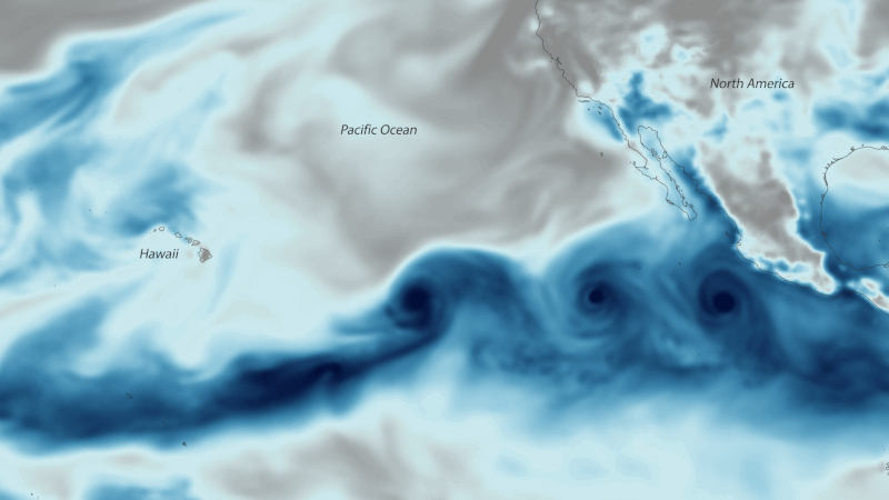 |
| Hurricanes Hilary and Irwin rotating around one another and merging in the eastern Pacific in 2017. Source: Wikimedia Commons |
I love this term. I really do. It hardly ever comes up unless there’s something cool in the weather models and meteorologists need something to talk about during quiet periods. The Fujiwhara Effect describes the tendency for two cyclones to orbit around each other if they get within a few hundred miles of each other.
There are a few fantastic examples of the Fujiwhara Effect in action, including with Hilary and Irwin in the eastern Pacific in 2017. A days-long water vapor animation is shown above—both because it’s really instructive and, well, it’s the only animation I could find that’s freely available for use.
If Laura and Marco get too close to each other in the Gulf of Mexico, they won’t start rapidly swirling around each other like two clumps of bubbles circling the drain. The practical effect would be that they would sort of throw each other off track, each pulling the other storm a little closer to it, which would nudge Laura’s track a bit farther west and Marco’s track a bit farther east.
During this interaction, just like when it comes to the storms duking it out through wind shear, the stronger and more well-organized storm will have the advantage over the weaker storm.
We’ll know more in the coming days, but if one storm continues to lag behind the other on their way to the Gulf, this particular adventure in physics might not be an issue at all as each storm moves toward the coast.
[Satellite: NOAA]
You can follow me on Twitter or send me an email.
Please consider subscribing to my Patreon. Your support helps me write engaging, hype-free weather coverage—no fretting over ad revenue, no chasing viral clicks. Just the weather.

