Skip to content
DAMWeather DAMWeather

The weather can get scary. Reporting on it doesn't have to be.

DAMWeather DAMWeather

The weather can get scary. Reporting on it doesn't have to be.

  • About Me
  • All Bylines
    • Books, Bylines, and Press
    • The Skies Above (Book)
    • Extreme Weather (Book)
    • The Weather Network
    • The Vane
    • Forbes
    • Capital Weather Gang
    • Mental Floss
  • Maps
    • Hurricane Maps
    • Hurricane Names
    • Monthly Tornadoes
    • Tornado Tracks
    • F5/EF-5 Tornadoes
    • SPC High Risk Days
  • GIS Resources
  • Contact Me
    • Bluesky
    • Facebook
    • Instagram
  • wxdam.com

Hurricane Warnings Continue For Florida As Struggling Isaias Approaches Land

By Dennis Mersereau
August 1, 2020 2 Min Read
Hurricane warnings remain in effect for much of eastern Florida this afternoon as Tropical Storm Isaias begins to move away from The Bahamas. The storm is struggling against a stream of dry air and wind shear trying to tear its convection apart, but it wouldn’t take much reorganization to regain some of its strength. Florida will begin feeling the effects of the storm tonight into Monday before the system accelerates up the East Coast through the middle of the week.
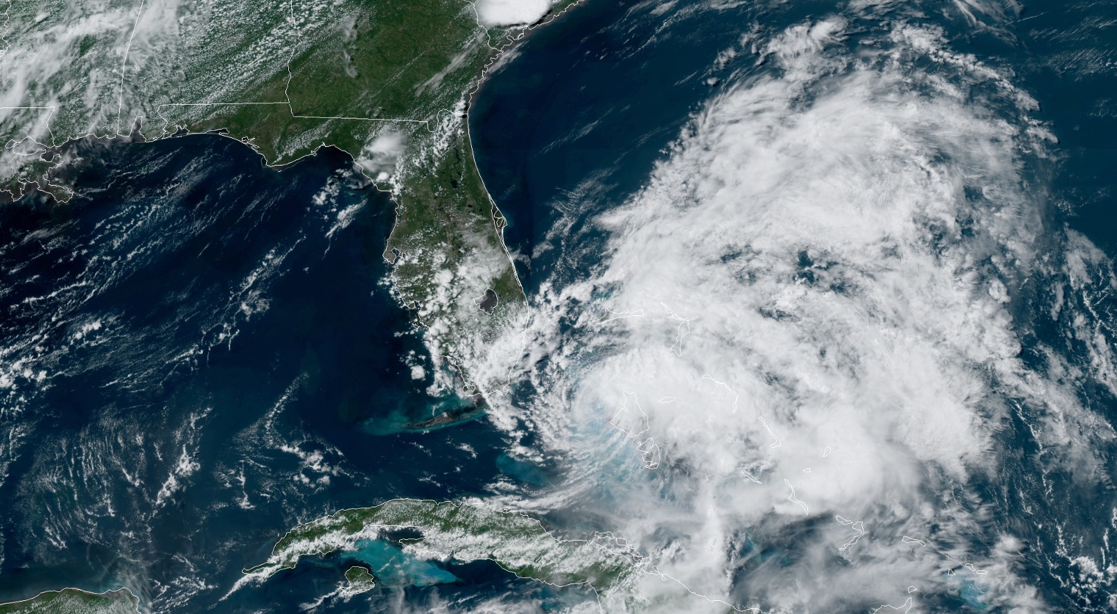
Isaias is a resilient storm. The storm lost some of its strength and organization on Saturday as dry air and wind shear chomped away at its structure. The “eye” of the storm was fully exposed at one point, shown above, looking more like a swirl of shampoo in a draining bathtub than an ominous hurricane.
It’s tried to get its act together since then. As of about 7:00 PM EDT, strong thunderstorms are trying to redevelop on the northern side of the circulation, and it wouldn’t take much organization to allow the storm to regain its footing. Satellite data and aircraft reconnaissance showed the storm teetering between 70 and 75 MPH late this afternoon, which is the line between tropical storm and hurricane. There’s not much of a practical difference between a strong tropical storm and a minimal hurricane. Given the uncertainty and the storm’s tenacity, tropical storm and hurricane conditions still appear likely over a large swath of the Florida Peninsula over the next 24-36 hours.
The 5:00 PM forecast from the National Hurricane Center calls for Isaias to regain hurricane strength as it comes perilously close to landfall in Florida. The storm will scrape Florida’s east coast through Sunday evening before it moves back over open water toward the Carolinas. Watches and warnings will accompany the storm up the coast; remember that these advisories don’t only exist along the shoreline, and hurricane and tropical storm force winds are possible well inland from the coast.
Heavy rain will remain the greatest threat from Isaias the farther north you go. The Weather Prediction Center’s rainfall forecast this afternoon paints 3-5 inches of rain along the path of the storm, which covers almost the entire length of Interstate 95. This much rain falling this fast will lead to the potential for widespread flash flooding, especially in areas that have seen heavy thunderstorms recently.
[Satellite: NOAA]

You can follow me on Twitter or send me an email.

Please consider subscribing to my Patreon. Your support helps me write engaging, hype-free weather coverage—no fretting over ad revenue, no chasing viral clicks. Just the weather.
 

Author

Dennis Mersereau

I have 15+ of experience providing hype-free weather information for folks across the United States and around the world. In addition to DAMWeather, I also contribute to The Weather Network as a digital writer and weather specialist.

Follow Me
Other Articles
Previous

Here’s Your Friday Night Update On Hurricane Isaias As It Approaches Florida

Next

Isaias Flirts With Hurricane Strength; Monday Night Landfall In Carolinas Likely


Local ◈ UTC
Facebook | Bluesky
Instagram | Threads | Email
DAMWeather is now ad-free! Everyone benefits from engaging, hype-free weather coverage. Please consider supporting my efforts through Patreon:


Order The Skies Above today!

Bookshop.org || Barnes & Noble
Mountaineers Books || Amazon

My latest book, The Skies Above, is now available!

Did you know a puffy cloud can weigh millions of pounds? Or that every rainbow you see is unique to you?

Our atmosphere is full of spectacular sights that are always within your reach. Glistening layers of fog, gorgeous sunsets, and brilliant meteors flashing through the sky can light up even the calmest day.

The Skies Above, published by Mountaineers Books, is a celebration of what we overlook when we look up. I was thrilled to work with the editors and illustrators at Indelible Editions to share with you the quotidian beauty of our sky.

Order your copy now and learn about the wonders we take for granted every day.

I teamed up with the editors of Outdoor Life magazine to write The Extreme Weather Survival Manual, your guide to surviving and thriving in almost any weather condition. Whether you're an avid outdoorsperson or you enjoy watching the radar from the comfort of your home, you're sure to find helpful tips, advice, and new bits of knowledge in this fascinating book.

You can buy my book today through Amazon.
An error has occurred, which probably means the feed is down. Try again later.
  • 2026 (30)
  • 2025 (49)
  • 2024 (59)
  • 2023 (43)
  • 2022 (57)
  • 2021 (71)
  • 2020 (83)
  • 2019 (88)
  • 2018 (92)
  • 2017 (1)
  • 2016 (4)
  • 2015 (10)

Copyright 2026 — DAMWeather. All rights reserved. Blogsy WordPress Theme