Isaias Flirts With Hurricane Strength; Monday Night Landfall In Carolinas Likely

Tropical Storm Isaias keeps fighting back against the atmospheric forces trying to tear it apart, managing to maintain its strength on Sunday as it paralleled Florida’s east coast. Forecasters expect the storm to flirt with hurricane strength as it accelerates toward landfall in the Carolinas overnight Monday and into Tuesday. Isaias has the potential to be a disruptive storm as it traverses the U.S. East Coast and brings dangerous wind gusts and flooding rain to densely populated areas.
The track forecast for Tropical Storm Isaias hasn’t changed much in the last few days. That kind of consistency is a good thing since it’s given folks in harm’s way ample opportunity to prepare for the potential for gusty winds, heavy rain, and power outages. The latest forecast from the National Hurricane Center shows the storm picking up speed over the next 24 hours as it approaches the Carolinas. Landfall is likely on Monday night around Myrtle Beach, S.C., or Wilmington, N.C.

Accordingly, tropical storm watches and warnings are in effect for a large swath from central Florida to southern Connecticut. A hurricane watch is in effect from South Santee River, S.C., to Surf City, N.C., just in case Isaias strengthens back into a hurricane. The map above shows all the county-based alerts in effect as of 11:00 PM on Sunday. The difference between a 70 MPH tropical storm and a 75 MPH hurricane is negligible, so the folks near the point of landfall can expect a period of damaging winds regardless of whether Isaias makes it back over that threshold or not.
 |
| Source: NOAA |
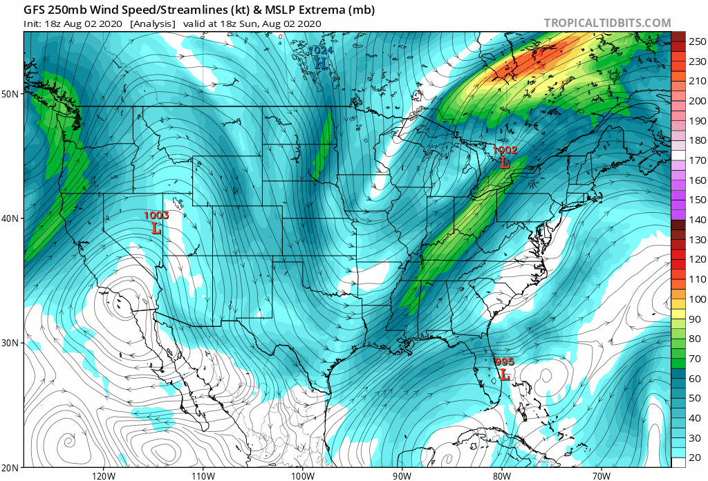
Tropical Storm Isaias looks pretty healthy tonight. It’s got strong thunderstorm activity bubbling near the center of circulation. There’s intense transverse banding in the outflow on the northern edge of the storm; this scalloped ridging is the result of turbulence and it’s common around healthy storms with robust convection that’s venting lots of air into the upper atmosphere.
Isaias is going to start losing some of its pure tropical-ness pretty soon. So far, the storm’s been influenced by two major features around it: a strong Bermuda High to its east that’s kept it from running back out to sea, and an upper-level trough over the Mississippi Valley that’s kept it from heading west into the Gulf. These two features combined are responsible for its very careful curve from the Caribbean into the Carolinas.
Isaias has been lopsided ever since it crossed Andros Island in The Bahamas. That’s why it was mostly just breezy and showery on Florida’s East Coast on Sunday even though the center of the storm is so close to shore that a daredevil could intercept it with a kayak.
 |
| Source: Tropical Tidbits |
However, the tropical storm is going to start to ‘feel’ that upper-level trough come Monday, deriving some of its energy and influence from the jet stream like a Nor’easter would. This will allow the storm to grow in size and accelerate up the coast.
Once it begins to grow and its structure changes a bit, the heavy rain and winds will start wrapping around and filling in the western side of the storm. This is why the forecast looks so much rougher in Wilmington than things look in Cape Canaveral right now, even though the center of the tropical storm is just a few dozen miles offshore of NASA’s launch pads.
Wind & Storm Surge
 |
| Source: NHC |
The strongest winds and heaviest rains will follow the core of Isaias as it moves inland on Monday night and Tuesday. Myrtle Beach and Wilmington will take the brunt of the storm; these areas could see a period of hurricane force winds and more than half a foot of rain. Widespread power outages are likely in areas that see strong winds. Keep your cell phones charged and your flashlights close by on Monday night.
Strong winds will continue into the Mid-Atlantic and Northeast on Tuesday and Wednesday. Tropical storm conditions (sustained winds of 40+ MPH) are possible as far west as Washington D.C. and Philadelphia. The latest NHC forecast calls for the storm to have maximum sustained winds of 45 MPH when it moves over New York City on Tuesday evening.
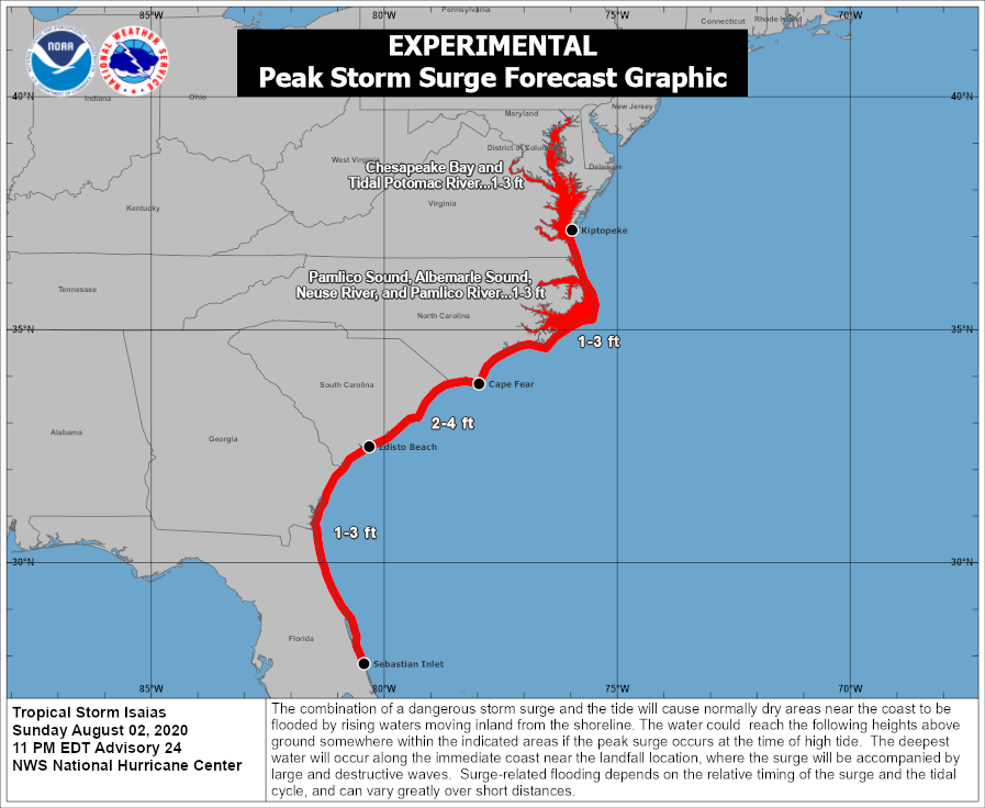
Even a strong tropical storm can lead to a storm surge along the coast, especially where the storm makes landfall. A storm surge of 2 to 4 feet above normal tide levels is possible between Edisto Beach, S.C., and Cape Fear, N.C. That doesn’t sound like much, but it’s life-threatening for homes along the coast that are susceptible to storm surge flooding, made even worse by the fact that rescue crews may not be able to reach homes inundated by flooding until after the worst of the storm has receded.
Heavy Rain & Flash Flooding

Flash flooding is likely along the Isaias’ track as it moves up the coast. The heaviest rain is likely in the Carolinas and Mid-Atlantic; the Weather Prediction Center calls for widespread totals of 3-5 inches from the point of landfall through New England, with higher totals likely in some locations if they get caught under a particularly heavy band.
Flooding from heavy rain is the leading cause of death in a landfalling tropical cyclone. It only takes a few inches of moving water to lift a vehicle and carry it downstream. It’s impossible to judge how deep the water is until it’s too late, and sometimes the road is even washed away under the moving floodwater.
Tornadoes

Tornadoes are always a threat when a tropical cyclone makes landfall. There’s enough low-level wind shear in these systems to spawn quick tornadoes, especially along and to the east of the storm’s forward motion. Right now, the greatest threat for tornadoes exists across eastern North Carolina on Monday night and Tuesday, where the Storm Prediction Center has issued a slight risk for severe weather.
Tropical tornadoes sometimes occur so quickly that the normal tornado warning lead time is reduced to just a few minutes at most. Stay close to safe shelter if you’re near the path of the storm, and make sure the emergency alerts are activated on your smartphone. (The option is usually under the settings for notifications.)
You can follow me on Twitter or send me an email.
Please consider subscribing to my Patreon. Your support helps me write engaging, hype-free weather coverage—no fretting over ad revenue, no chasing viral clicks. Just the weather.

