November 28, 2022

Strong Tornadoes Are Possible Across The Mid-South On Tuesday


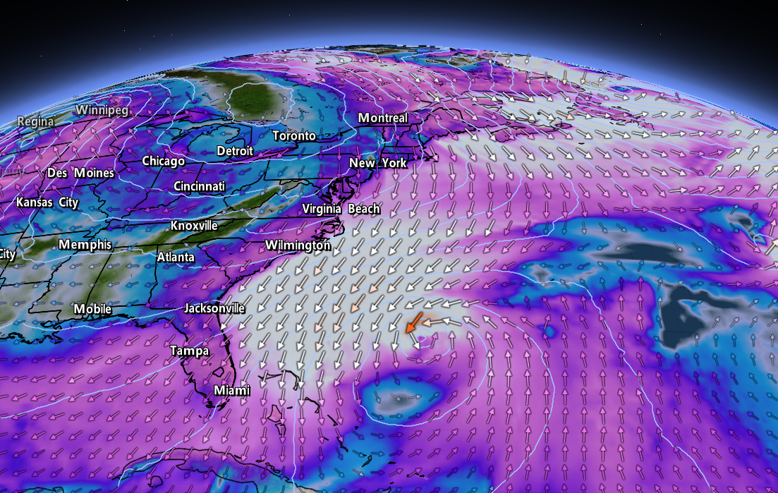
We're staring down a classic late-fall severe weather setup across parts of the southern United States on Tuesday, and forecasters are concerned about the potential for significant tornadoes in the Mid-South as storms fire up through the day.

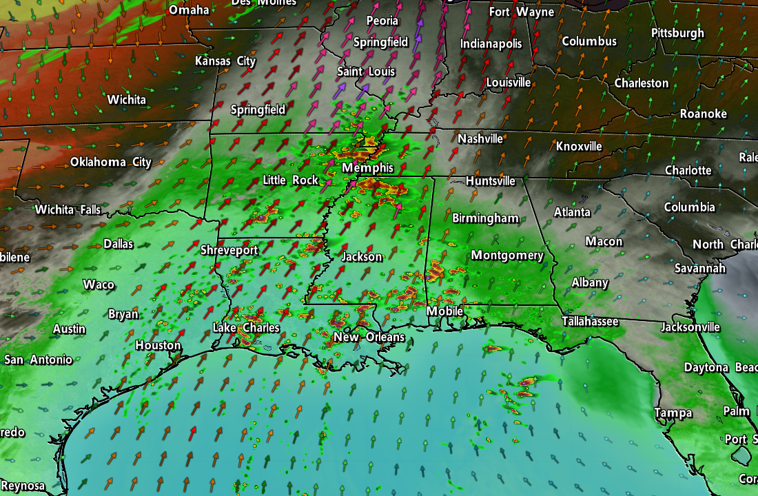
A low-pressure system developing over the Midwest will drag warm, moist air north from the Gulf of Mexico. A cold front will crash into this instability, providing the spark needed for thunderstorms to fire up across the lower Mississippi River Valley.

There's enough wind shear through the atmosphere to allow some of those thunderstorms to grow into supercells. Forecasters with the Storm Prediction Center are worried there will be enough instability and 'spin' in the atmosphere to produce strong, long-lived tornadoes across the region.


Anticipating the threat, the SPC issued a moderate risk for severe weather across parts of Louisiana, Arkansas, Mississippi, and southwestern Tennessee for the day on Tuesday. A moderate risk is a 4 out of 5 on the scale measuring the risk for severe thunderstorms on a given day. Significant, long-lived tornadoes are also possible throughout the enhanced risk zone that covers larger portions of those four states. 

Thunderstorms will fire up during the late morning hours, peaking in intensity and coverage through Tuesday afternoon. As we usually see during a setup like this, the storms will likely begin to merge and evolve into one or more squall lines as we close in on the evening hours, transitioning the threat over to damaging straight-line winds with a risk for embedded tornadoes.


Given the potential for supercells, the biggest concern here is the potential for one or more significant tornadoes. The SPC issued the moderate and enhanced risks almost entirely based on Tuesday's tornado threat. The black hatching indicates the risk for strong, long-lived tornadoes. A 10-15% chance for tornadoes doesn't seem like much, but it's all relative considering the average odds of seeing a tornado on any given day is basically nil.
The greatest chance of tornadoes at the end of November is right around where we're expecting severe weather on Tuesday. (NOAA/SPC)
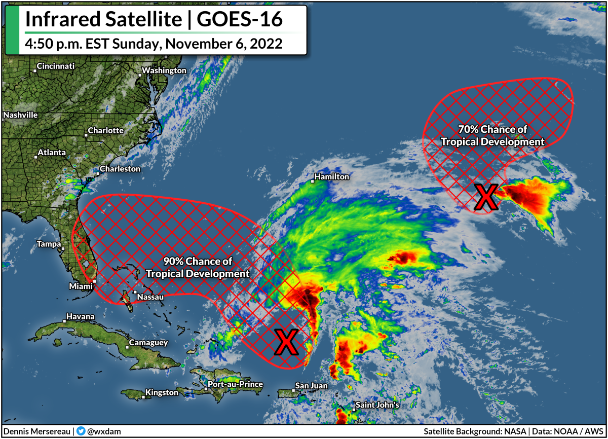
Severe weather is common in the southern U.S. during the late fall and winter months, and it's for pretty much the same reason we see a huge uptick in severe weather during the spring months. Spring and fall are both transition seasons that strengthen the jet stream, giving way to robust low-pressure systems that can foster severe thunderstorms.

Make sure you have a way to receive warnings the moment they're issued. Check your phone and ensure that emergency alerts are activated for tornado warnings. These free push alerts may be annoying, but they're proven lifesavers and can alert you to a tornado warning for your location before many other apps or devices do. Seconds count when a dangerous storm is barreling toward you.

[Top image created using WSV3]


You can follow me on Twitter or send me an email.

Please consider subscribing to my Patreon. Your support helps me write engaging, hype-free weather coverage—no fretting over ad revenue, no chasing viral clicks. Just the weather.


November 17, 2022

Buffalo Could See 4-5 Feet Of Snow Through The Weekend, As One Does


Oh dear. 

A vigorous lake-effect snowstorm is about to get underway in western New York, where the National Weather Service expects 4-5 feet...feet...of snow to fall across the Buffalo metro area by Sunday.

This will be a lake-effect event for the ages, so long as "the ages" stop back in 2014, when a very similar setup resulted in 65 inches of snow falling south of Buffalo in a couple of days.

NWS Buffalo

We're witnessing a classic event that'll probably land in some meteorology instructor's PowerPoint slides one day.

Cold winds blowing across the Great Lakes behind a cold front are setting the stage for ripping bands of snow to develop across the eastern Lakes.

These southwesterly winds will align perfectly along the length of Lake Erie to instigate the development of a long, steady band of snow that'll train its fire on the Buffalo metro area. The band of snow will pick up in earnest overnight Thursday into Friday, continuing into the day Saturday for many areas.

The band will ultimately wobble a few miles to the left and a few miles to the right, but forecasters are confident that this will be a high-impact storm that'll smack Buffalo one good.

NWS Buffalo gives the city a 99% chance of seeing at least 18 inches of snow over the next couple of days, and the office's official forecast casually paints a bullseye of 48-60 inches of snow over the city.

NWS Buffalo

What's behind this? Much like thunderstorms on a warm day, lake-effect snow forms through convection. The lakes hold on to their heat really well even as the air turns bitterly cold, setting up a sharp temperature gradient between the lower levels and the upper levels.

The warm lakes heat up the air directly above them, allowing the air to rise and trigger snow showers. Winds organize the showers into bands. A scenario like the one we're seeing now—a great temperature difference combined with winds perfectly aligned with the length of Lake Erie—will lead to...well, the road-glaciating event we're about to witness.

Buckle up, western New York. This'll be one you talk about with the gusto of a shipwreck survivor when the south falls apart in two inches of snow in a few months.

[Top image created with WSV3]


You can follow me on Twitter or send me an email.

Please consider subscribing to my Patreon. Your support helps me write engaging, hype-free weather coverage—no fretting over ad revenue, no chasing viral clicks. Just the weather.


November 9, 2022

Hurricane Warnings Continue As Sprawling Nicole Nears Florida Landfall


Nicole is on the verge of hurricane strength this afternoon as the storm steadily pushes west through The Bahamas. Forecasters expect then-Hurricane Nicole to make landfall along Florida's east coast on Wednesday night, gradually pushing across the peninsula through the day on Thursday.

This is an odd storm compared to most tropical systems that Florida is used to dealing with. It's late in the season, for one, and Nicole didn't start its life as a purely tropical system. The storm's subtropical origins made it a very large system, so it's swirling toward land as a sizeable storm with a footprint to match.


Nicole's tropical storm force winds extend almost 500 miles from the center of the storm, so this system will have far-reaching impacts regardless of where the very center of the storm makes landfall. The National Hurricane Center expects Nicole to emerge in the eastern Gulf of Mexico on Friday, making its final landfall on the Panhandle before racing inland through the weekend.


Hurricane warnings are in effect for much of eastern Florida ahead of Nicole's landfall on Wednesday night. Tropical storm warnings blanket most of Florida, all of coastal Georgia, and reaching coastal South Carolina about halfway between Charleston and Myrtle Beach. A wind advisory is in effect for much of interior Georgia, and it stands to reason that more wind advisories will pop up over the next 24 hours. 

Again...big storm.


Widespread gusty winds will lead to downed trees and power outages across the southeastern U.S. over the next couple of days. There were only about 6,500 power outages across Florida by noon on Wednesday, but that number will tick upward as the core of the storm draws closer through the day. The storm's effects won't stop at the coast, of course. Nicole's size and path will make power outages and spotty wind damage likely throughout inland sections of Georgia and the Carolinas.

Storm surge warnings are in effect for much of the coast ahead of Nicole's landfall. The NHC's latest forecast calls for up to 3-5 feet of storm surge along most of Florida's east coast if the peak surge coincides with high tide, with up to 2-4 feet of storm surge possible up to Charleston, S.C., in the same scenario.


Heavy rains will follow the storm inland through the weekend. There's a slight risk for flash flooding along the storm's path as it treks inland across the East Coast over the next couple of days. This isn't going to be a blockbuster rainfall event. We'll see a big swath of 1-3 inches of rain along Nicole's path, with locally higher amounts possible. Some flooding issues are possible in vulnerable areas. Leaves clogging storm drains could lead to additional flooding on some roads and parking lots.

There's also a risk for severe weather across eastern sections of Florida, Georgia, and the Carolinas. As with any landfalling storm, the eastern side of the system is ripe for rotating thunderstorms that could produce quick tornadoes. Tropical tornadoes happen quickly and with reduced tornado warning lead time, so make sure you have a way to receive warnings the moment they're issued.

Once Nicole (and the cold front sweeping it along) clear away from the East Coast this weekend, it's going to be a much quieter—and much colder—pattern settling in next week. Daytime highs only reaching the 40s will dip deep into the southeastern states. Gotta love late fall.

[Top image created using WSV3]


You can follow me on Twitter or send me an email.

Please consider subscribing to my Patreon. Your support helps me write engaging, hype-free weather coverage—no fretting over ad revenue, no chasing viral clicks. Just the weather.


November 6, 2022

A Tropical Disturbance Could Bring Foul Weather To The East Coast This Week


You didn't think we'd get off that easily, did you?

After a rough round of severe weather this week broke a remarkable stretch of dulcet autumn weather across the United States, the tropics felt the need to get the last word.

A tropical disturbance in the southwestern Atlantic Ocean has a decent shot at becoming this hurricane season's 14th named storm, and it could have its sights set on Florida and the East Coast in the days after this week's election.

Possible Mid-Week Headache


It doesn't look like much on satellite right now—it more closely resembles a gallbladder than a tropical system this evening—but environmental conditions will gradually become more favorable for development over the next few days. The National Hurricane Center gives the disturbance a 90 percent chance of turning into a tropical or subtropical storm by the middle of the week.

Regardless of its ultimate development, most models bring the disturbance and/or system into Florida before it interacts with a cold front and turns north to track up the eastern seaboard.

Some models are developing the system more than others—the GFS model, for instance, is trying to turn it into a strong tropical storm or even a hurricane before hitting southeastern Florida on Wednesday or Thursday. Even though that's probably an outlier at this point, there's a growing consensus that we'll probably have a named storm on our hands before long.

Tropical vs. Subtropical: What's The Difference?

Honestly, just as an aside, I can't stand talking about "subtropical storms" because the term becomes a distraction. Everyone loves a good process story (me included!) and it sometimes crowds out the actual impacts of the storm.

The distinction between a tropical system and a subtropical system is mostly technical. It's helpful to think about low-pressure systems as existing on a spectrum instead of fitting into neat little boxes. A subtropical system has characteristics of both a tropical cyclone and an extratropical cyclone, or the 'everyday' type of low-pressure system we deal with on a regular basis.

A tropical cyclone features warm air throughout the storm and it derives its energy from thunderstorms packed around the center of the cyclone. An extratropical cyclone, on the other hand, features cold and warm fronts, and typically gathers its strength from upper-level winds. 

Subtropical cyclones sort of meet in the middle—there's some cold air in there, it's a little asymmetric, it gets some of its energy from thunderstorms and a touch from upper-level winds. Again, it's mostly technical! But the bottom line is that a subtropical storm is indistinguishable from a 'normal' tropical storm when you're in the thick of it, so the NHC issues forecasts and warnings on it just the same.

Lots Of Rain From Miami to Moncton


If you live along the East Coast, it's a good idea to check if you've got supplies to deal with power outages. It's also important to mentally review your plans for what to do in the event of flooding at home or if any of your daily routes encounter water-covered roads. The number-one danger in any landfalling storm is freshwater flooding from heavy rainfall. It only takes a little bit of water to lift up a vehicle and carry it downstream.

Taking a look at the Weather Prediction Center's 7-day precipitation forecast shows the potential for heavy rain up and down the East Coast over the next week. The system will interact with a Colorado low heading toward the western Great Lakes, helping to produce widespread rainfall across the eastern U.S. toward the latter half of the week. There's a chance we could see gusty winds and pretty heavy rainfall for parts of New England and the Canadian Maritimes by the end of the week.

You'll notice on that map a few sections up that there's another disturbance way out in the oceanic boondocks that could develop into a tropical storm over the next couple of days, but don't worry about it—it's only a concern for fish and ships.

Upcoming Storm Could Make A Terrible Season 'Average'


The next two names on this year's list for the Atlantic basin are Nicole and Owen.

If either one of these systems develops, it would become the 14th named storm of the 2022 hurricane season, making this season exactly average in terms of number of named storms. A typical Atlantic hurricane season sees 14 named storms, 7 hurricanes, and 3 or 4 major hurricanes. As of this post, the current count is 13/7/2.

It's been a weird year. Just about all forecasters expected another very active hurricane season based on La NiƱa continuing in the eastern Pacific Ocean. Things didn't work out that way. It takes lots of ingredients for tropical cyclones to come together, and even though the overall pattern was favorable, individual ingredients kept misaligning and throttling most opportunities for storms to form.

We saw an unprecedented gap in storms between Tropical Storm Colin dissipating on July 3rd and Tropical Storm Danielle forming on September 1st.

Calling this season average feels like a grim understatement. The old mantra of "it only takes one" sure came through this year.

Hurricane Fiona smacked into the Maritimes as one of the region's worst storms in living memory. Just a week later, Hurricane Ian hit Florida as a high-end category four and the state's deadliest hurricane since the Labor Day Hurricane of 1935, killing almost 150 people.

Mariah is on the radio and the stores are bursting with glittery decorations, but hurricane season doesn't 'officially' end until November 30th and we can even see the occasional stray storm wander into December. Don't let your guard down yet.

[Top image created using WSV3]


You can follow me on Twitter, Facebook, or send me an email.

Please consider subscribing to my Patreon. Your support helps me write engaging, hype-free weather coverage—no fretting over ad revenue, no chasing viral clicks. Just the weather.