Two Atlantic Storms Heading For Land; Flooding Threat Growing On Gulf Coast

A tropical storm warning is in effect for a portion of the Texas coast as a tropical depression drifts west across the Gulf of Mexico. The system, regardless of its status at landfall, could bring heavy rain and rough seas to coastal communities from Brownsville to Mobile. While that’s the immediate concern, there’s a strengthening tropical storm far out in the Atlantic that we’ll need to keep an eye on as it moves into the Caribbean later this week.
Tropical Depression Eight

Satellite imagery and Hurricane Hunter aircraft found that the tropical disturbance in the Gulf of Mexico developed into a tropical depression on Wednesday afternoon. It’s struggled to maintain its composure a bit over the last 24 hours, but it’s starting to look healthier on satellite imagery today and it might make it to tropical storm strength before too long.
The NHC’s forecast turns this into Tropical Storm Hanna by Friday, bringing it into the coast on Saturday with maximum winds near 60 MPH. That’s enough to bring down trees and power lines, especially where the soil is loose from the heavy rain. A tropical storm warning is in effect for the coast and inland counties around where the system/future-Hanna is forecast to make landfall, including Corpus Christi and Victoria.

Heavy rain is the greatest threat from this system no matter what it’s called by the time it reaches land. Some communities could see up to half a foot of rain if they’re caught beneath training bands of heavy showers and thunderstorms. The greatest rainfall totals are likely near where the system makes landfall this weekend, but rain associated with the system will bring the potential for flooding as far up the coast as Mobile, Alabama, where forecasters expect several inches of rain through next week.
Tropical Storm Gonzalo
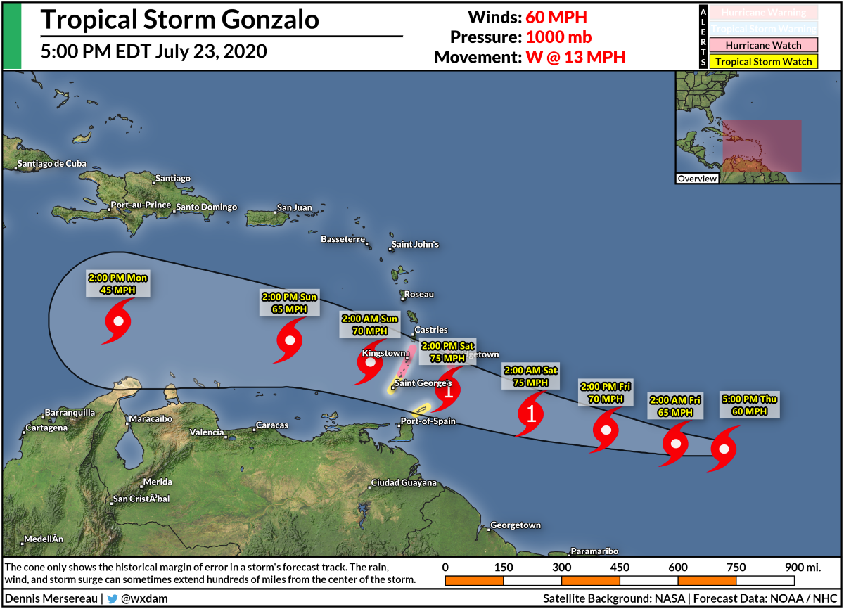
Gonzalo is our seventh named storm of the year, setting yet another record for the most named storms so early in the season. We typically don’t see our first hurricane until mid-August and it usually takes until the peak of hurricane season to reach our seventh named storm. (If the tropical depression in the Gulf becomes Tropical Storm Hanna, that will set another record for the earliest “H” storm.)
This is the first tropical system we’ve seen form out in the tropical Atlantic Ocean, an area between the Caribbean and the west coast of Africa known as the “main development region,” or MDR. With the exception of Tropical Storm Cristobal, every other storm we’ve seen in the Atlantic in 2020 developed from non-tropical origins.
The tropical storm might undergo a period of intensification soon and the National Hurricane Center’s forecast calls for Gonzalo to reach hurricane strength by Thursday. A hurricane watch and a tropical storm watch are in effect for the Windward Islands in the path of the storm. This is a tiny storm right now; the 5PM advisory found its tropical storm force winds only extended about 25 miles from the center of the storm. Gonzalo’s precise track will determine which islands see the worst conditions, especially if the storm remains compact as it is now.
Forecasters expect Gonzalo to continue into the Caribbean on a general weakening trend through the weekend. It’s a bit of an open question right now whether the storm will completely degenerate once it reaches the Caribbean or continue to hang on as it treks west. If it hangs on, there’s a chance it could redevelop in the western Caribbean this weekend or early next week.
[Satellite Image: College of DuPage]
You can follow me on Twitter or send me an email.
Please consider subscribing to my Patreon. Your support helps me write engaging, hype-free weather coverage—no fretting over ad revenue, no chasing viral clicks. Just the weather.

