Two Hurricanes Could Make Landfall This Weekend: One In Texas, The Other In Hawaii
This weekend could see the rare occasion when two different hurricanes make landfall in the United States just one day apart. The latest forecast from the National Hurricane Center predicts that Tropical Storm Hanna will reach hurricane strength before coming ashore near Corpus Christi, Texas, on Saturday, followed by the potential landfall of Hurricane Douglas on the Hawaiian Islands on Sunday.
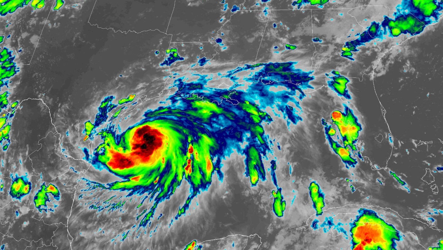
Texas: Tropical Storm Hanna

Hanna is doing its best to take full advantage of the environment over the Gulf of Mexico. The storm has a mean look to it on satellite imagery—that’s a technical analysis, of course—with a broad curvature, decent upper-level outflow, and deep convection around the center of the system. Pretty much the only good thing we’ve seen so far is that the storm’s ingested a bit of dry air into its core, slowing down the rate of organization and strengthening.
Even so, given its current organization and the favorable environment ahead of it, the NHC expects the system to make a run at hurricane strength before making landfall on Saturday afternoon.
Flooding Rains

The big story with Tropical Storm Hanna is the flooding. Some areas could see up to a foot of rain from this storm over the next couple of days. It won’t take much heavy rain to produce flash flooding, especially in arid areas where the ground isn’t capable of absorbing water as efficiently.
A risk for flash flooding exists along Hanna’s general track, where the Weather Prediction Center expects a broad swath of 4-8 inches of rain from the coast into northern Mexico.
Freshwater flooding is the leading cause of death from a landfalling tropical system in the United States. Inevitably, someone will think they’re invincible or that they’ve got impeccable judgement and they’ll try to drive across a flooded roadway only to get stuck and washed downstream. It’s impossible to judge how deep the water is before you’re in it and it’s too late. It takes a surprisingly small amount of water to lift a vehicle and carry it downstream.
Wind and Surge
Current forecasts bring the center of the storm ashore near Corpus Christi on Saturday afternoon. Normally, this is the part where I’d stress that the forecast only applies to the center of the storm, and the wind, rain, and storm surge can extend hundreds of miles from the eye. That’ll certainly be the case with Hanna’s flooding rains. However, this is a compact storm with a compact core of strong winds. It very much matters where it makes landfall; a few miles north or south could mean the difference between a breezy day and a solid thump in a city that’s home to more than 300,000 people.
There’s little difference between a 70 MPH tropical storm and a 75 MPH hurricane, so its title doesn’t matter much but to folks who love technicalities. Wind damage is likely where the core of the storm comes ashore, but tropical storm force winds extend several dozen miles away from the center and it won’t take much wind to knock down trees and power lines when the soil is wet.
Tornadoes
A risk for tornadoes exists with any landfalling tropical cyclone. The greatest threat for tornadoes lies in the right-front quadrant of the storm relative to its forward motion—in Hanna’s case, that’s going to be the northern side of the storm.
Tropical tornadoes happen fast and, as a result, they often touch down with reduced lead time. They’re more common in the rain bands than the shield of rain around the center of the storm itself, but they can occur close to the center if an embedded thunderstorm can tap into enough spin in the atmosphere.
Hawaii: Hurricane Douglas

Not even 24 hours after Hanna hits Texas, we’ll have to look a few thousand miles west and watch nervously as Hurricane Douglas closes in on Hawaii. A hurricane watch is in effect for the Big Island, Maui, Lanai, Molokai, and Kahoolawe, which includes the cities of Hilo and Kahului. It’s likely watches will be extended west toward Honolulu over the next day or so.
Douglas strengthened into a major hurricane this week. It’s going to begin a slow but steady weakening trend over the next few days as it traverses cooler waters near Hawaii. Previous storms that approached Hawaii in recent years fell apart in dramatic fashion as they approached the Big Island. Forecasters expect Douglas to weaken slowly, though, due to low vertical wind shear trying to tear the storm apart.
The latest forecast shows the storm traversing the length of the island chain. Conditions will rapidly deteriorate on the Big Island on Saturday evening, worsening across the islands from east to west through the day on Sunday.
Wind
Douglas, like Hanna, has a relatively small core of strong winds around the eye of the storm. However, Douglas’ predicted track could expose most population centers in the state to a period of dangerous conditions this weekend. A small wobble in either direction could have huge implications in who sees the worst weather.
Hurricane conditions are possible on portions of the Big Island and Maui if the center tracks very close to land. This kind of wind will lead to widespread tree damage, lengthy power outages, and structural damage. Falling tree limbs are a serious danger to motorists, pedestrians, and homes; if you live in Hawaii and you’re in the path of the storm, stay away from rooms where large trees or limbs could fall through the roof or walls.
Heavy Rain
Flash flooding is a serious hazard with Hurricane Douglas. The mountainous terrain allows heavy downpours to turn into flash floods and mudslides in a hurry. The Central Pacific Hurricane Center warns that 6 to 10 inches of rain are possible, with total amounts of more than a foot of rain possible along the windward side of high terrain.
[Satellite: NOAA]
You can follow me on Twitter or send me an email.
Please consider subscribing to my Patreon. Your support helps me write engaging, hype-free weather coverage—no fretting over ad revenue, no chasing viral clicks. Just the weather.

