

Hurricane Melissa rapidly intensified from a tropical storm to a Category 4 hurricane in about 24 hours as the system churns over the extremely warm waters of the northern Caribbean Sea.
The storm, which is just south of Jamaica, will slowly move over the island nation over the next couple of days. Widespread and potentially catastrophic flash flooding and mudslides are likely, along with devastating wind damage and a destructive coastal storm surge.
Widespread Damage Likely
Ask any meteorologist their worst-case scenario for a high-end landfalling hurricane and a situation like Hurricane Melissa will probably rank high up on the list.

Melissa is about as strong as an Atlantic hurricane can get and it’s moving at a snail’s pace toward Jamaica, a heavily mountainous island that’s home to millions of people.
Whether the storm reaches Jamaica as a Category 4 or a Category 5 on Monday and Tuesday, the effects will be devastating for the region.
A constant surge of tropical moisture streaming across the heavily mountainous island will produce rainfall totals of 20-30 inches, with some communities possibly picking up more than 40 inches of rain through Tuesday night.
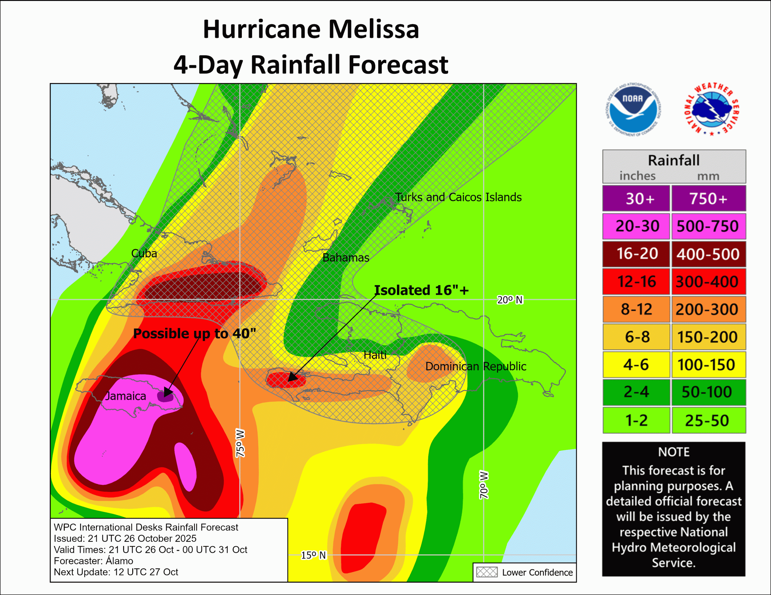
This absolute glut of water will lead to widespread and potentially catastrophic flash flooding and mudslides; think about what happened in western North Carolina during Helene last year, and double it several times over.
Extreme, long-duration winds will destroy many homes and businesses along the path of the eyewall. Utility outages will likely last for months in the hardest-hit areas. Trees will be defoliated and vast swaths of cropland will be destroyed.
The NHC says a storm surge of 9 to 13 feet is possible as Melissa makes landfall, an inundation of seawater that will cause major damage to coastal communities east of where the eye makes landfall.
After crossing Jamaica, the hurricane will pass over eastern Cuba with flash flooding and wind damage. Melissa will begin accelerating to the northeast from there, potentially threatening Bermuda at hurricane strength later this week.
A season of high-end hurricanes
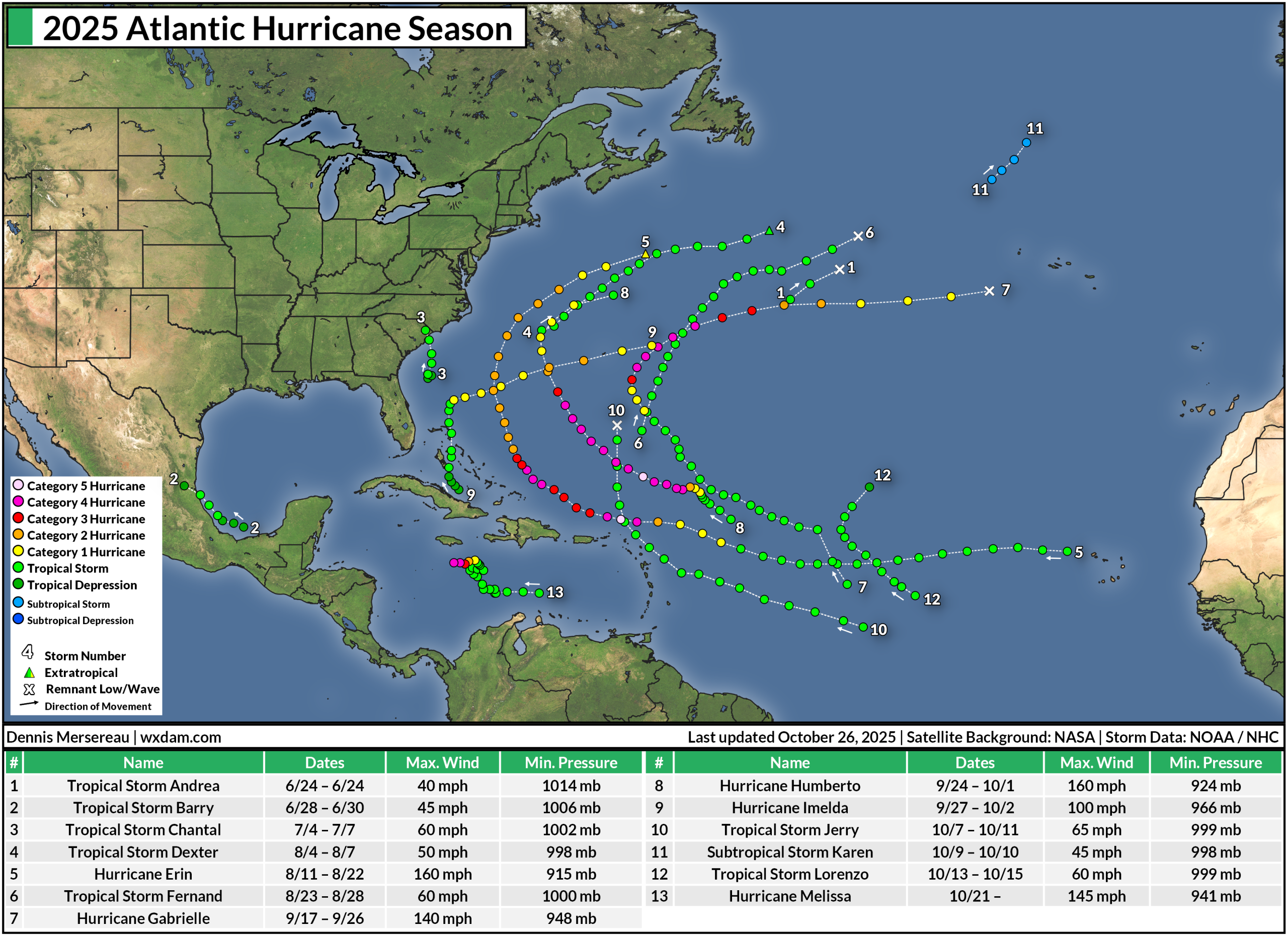
As I wrote last week, this has been a very strange hurricane season. This year’s activity has been all-or-nothing, with storms that either struggled mightily or just reached for the stars.
We’ve had five hurricanes this year:
- Erin: Category 5, 160 mph peak
- Gabrielle: Category 4, 140 mph peak
- Humberto: Category 5, 160 mph peak
- Imelda: Category 2, 100 mph peak
- Melissa, Category 4, 140 mph peak (so far)
Since 1850, only one other Atlantic hurricane season has recorded more than two Category 5 storms. (The other was 2005 with Emily, Katrina, Rita, and Wilma.)

Extremely warm waters and favorable atmospheric conditions allowed Melissa to undergo a period of explosive intensification between Saturday and Sunday, growing from a tropical storm to a Category 4 hurricane in just 24 hours.
Follow me on Facebook | Bluesky | Instagram
Get in touch! Send me an email.
Please consider subscribing to my Patreon. Your support helps me write engaging, hype-free weather coverage—no fretting over ad revenue, no chasing viral clicks. Just the weather.
