A Significant, Disruptive Winter Storm Will Hit North Carolina This Weekend

The winter storm we’ve been watching for the past week is almost a certainty at this point. North Carolina stores are quickly running out of the staples as residents collectively realize that we’ll be sitting around the house for a couple of days. A disruptive winter storm will trek across the southern United States this weekend, and the brunt of the snow and ice is expected to unfold across western and central North Carolina. Some locations could see more than a foot of snow, which is on the high-end of winter storms for this part of the country.
What We Know
Heavy snow is almost a certainty across much of North Carolina. Just about everyone west of Interstate 95 in North Carolina will see some amount of wintry precipitation from this storm. The heaviest snow will occur in the western and central parts of the state—think Asheville, Charlotte, and Greensboro—while areas east of there are more likely to see sleet, freezing rain, and plain ol’ rain than anything else.
It won’t just be North Carolina. The major focus is on North Carolina, but the surrounding states will also see a thump of winter weather. The mountains of southwestern Virginia stand the best chance to see disruptive snowfall totals as well as sleet and freezing rain that could make it impossible to walk or drive and could expose residents to power outages. Snow and ice is also possible in parts of upstate South Carolina and the mountains of eastern Tennessee.
Sunday will be the worst day. The low-pressure system will approach the state from the west on Saturday night. Snow will begin to overspread western and central North Carolina on Sunday morning and continue to grow in coverage and intensity through the day. The snow will be so heavy in spots that snow plows will have a hard time keeping up even on the major highways.
Snow and ice may linger through Monday. The bulk of the heavy snow and ice should subside during the early hours of Monday, but some precipitation may linger through Monday morning. It’s going to be incredibly difficult to travel in western and central N.C. on Monday anyway, so it won’t make too much of a difference.
Beware the wobbles. You’ve been warned. The effects of a storm like this are wholly dependent on the track of the low-pressure system. If the storm deviates even a dozen or two miles to the north or south of its current predicted track, that shift will mean all the difference for the location of the rain/ice/snow line and the axis of the heaviest snows. Likewise, if temperature profiles shift by a few miles, the sleet and freezing rain will follow. I guarantee you that some towns bracing for epic snows will see a decent snow followed by lots sleet or freezing rain, which will compress the snow into a dangerous sheet of ice. Lots of independent variables have to come together perfectly for a major snowstorm in this part of the country. It’s hard to do.
Some areas will flirt with records. North Carolina sees snow pretty reliably every year, but these annual snowstorms usually aren’t blockbusters. They clip the state, drop something like 2-6″ of snow, snarl traffic for a day or two and then everything gets back to normal. A big-time snowstorm with forecasts freely bouncing around figures like 12″+ is…not typical for this area!
This state isn’t great at handling snow. Drivers aren’t used to driving in snow. Crews don’t have enough equipment to keep the roads clear like they do up north. Heck, even many apartment complexes (mine included) don’t plow or shovel, leaving residents stranded in their parking spots if they don’t have a vehicle that can traverse a foot of snow.
Sorry folks, state’s closed. When we get lots of snow like what’s forecast for this weekend, it shuts everything down until the snow can melt. I guarantee you that there’s some county in this state that will have no school all week. Before you scoff, think about what happened a few weeks ago when road crews in the New York City metro were caught unprepared for snow that was heavier than forecast. Plows couldn’t keep up with the snow, grinding traffic in the NYC metro to a halt. Remember how easily things fall apart the next time you see the infamous flaming snow car.
What We Sorta Know

We’re close enough to know some snowfall totals now. The latest forecast from the National Weather Service and the Weather Prediction Center (whose forecast is shown in my map above) is pretty settled into a significant, disruptive snowstorm across the western half of North Carolina. These snowfall totals are subject to change over the next day or two as forecasters refine their thinking on the track of the storm and location of the freezing line above the surface.
Western North Carolina: The mountains of western North Carolina stand the best chance to stay all-snow during this storm. It’s likely that many areas here will easily see more than a foot of snow by the end of the storm. Some lower elevations may start to mix with sleet or freezing rain by the end of the storm on Sunday night—compressing and glaciating the blanket of snow—but many areas will escape this fate.
North-Central North Carolina: Communities (like mine!) in the middle of the state near the Virginia border could see hefty snowfall totals, but they also run a decent risk of seeing ice mix in with the snow. We could push double-digit totals in places like Winston-Salem, Greensboro, Burlington, and Reidsville if we manage to stay mostly snow. Totals will drop precipitously (sorry) if sleet or freezing rain begins to mix in. The deepest snows should occur north of Interstate 40/85.
South-Central North Carolina: Locations along and south of I-85 stand the best chance to see ice during this storm, which could significantly limit snowfall totals and make the storm even more dangerous than if it were pure snow. That sharp cutoff is readily apparent on the Weather Prediction Center’s snowfall forecast, shown above.
Virginia: Most of the snow in Virginia will fall across the southern part of the state near the North Carolina border. The cities with the best chance for significant snowfall totals are Roanoke, Blacksburg, Martinsville, and Danville. Accumulating snow is possible as far north as I-64. The storm should stay far enough south that Virginia shouldn’t have to deal with much ice at all—precipitation here should remain all snow.
South Carolina: There will be a sharp cutoff between snow, ice, and rain close to the low’s track as it moves across Georgia and South Carolina. The most snow will fall in far upstate South Carolina, with the heaviest totals likely right along the NC/SC border.
Tennessee: Given the complex setup of cold air that’s allowing it to snow and sleet and freezing rain in the first place, much of Tennessee should be spared from the wintry effects of this storm. The mountains right along the NC/TN border will see heavy snow, but there will be a sharp cutoff in snowfall to the west.
Who’s going to get ice? Freezing rain is most likely across northern Arkansas, parts of Tennessee, and some parts of central North Carolina that wind up right on the line between snow and rain. All of the areas that experience freezing rain will have impassable roads until the ice starts to melt. You can’t drive on a sheet of ice no matter how good you think your vehicle is.
Get ready for power outages. The combination of heavy, wet snow, gusty winds, and freezing rain will lead to power outages in some areas. They shouldn’t be as widespread as you’d see after a severe thunderstorm outbreak or a horrific ice storm, but some areas will lose power during this storm and they may not get it back right away. That’s no good when it’s cold and wet. Make sure you’re prepared for a power outage with food you don’t have to cook, batteries to power things like flashlights and radios (remember those?), and a way to charge your cell phone in a vehicle or with a portable power pack.

There’s going to be lots of heavy rain. Areas that don’t get to see wintry precipitation will still see rain—and lots of it. Some parts of the deep south will see flooding rains from this storm. The latest forecast from the Weather Prediction Center shows a widespread area of heavy rain stretching from central Texas to the coast of the Carolinas. Widespread parts of Texas and Louisiana could see more than 5″ of rain. This kind of rain in such a short period of time will lead to flooding issues.
Some severe thunderstorms are also possible. As if everything else isn’t enough, some severe thunderstorms are possible along the northern Gulf Coast on Friday and Saturday. The main threats will be damaging winds and quick tornadoes. The threat warrants paying close attention to watches and warnings as they’re issues. Some of the storms will occur at night, so it’s a good idea to make sure your cell phone has the ability to receiving warnings and audibly warn you when it receives an alert.
The Dam Setup
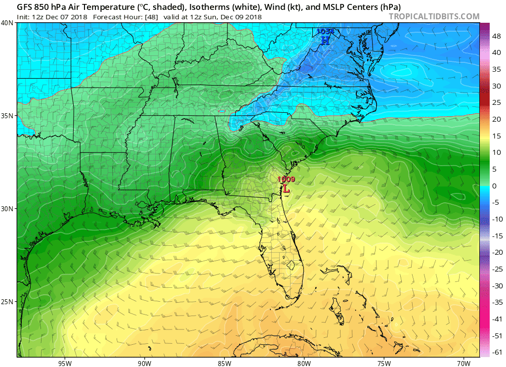 |
| Source: Tropical Tidbits |
This storm is a classic setup for snow and ice across the southeastern United States. The overall setup behind this snowstorm involves a low-pressure system moving across Georgia and South Carolina and a high-pressure system over the Mid-Atlantic.
History Repeats
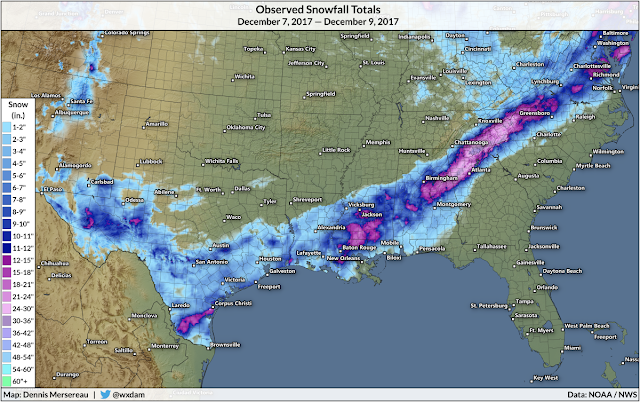 |
| Snowfall totals from the storm of December 7-9, 2017. |
Please consider subscribing to my Patreon. Reader-funded news is more important than ever and your support helps fund engaging, hype-free weather coverage.

