Raucous Storm Set To Spawn Tornadoes, Fires, And A Blizzard This Week

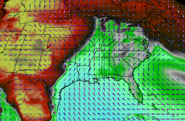
A significant storm that’ll develop over the center of the country this week will bring a wide range of hazardous weather along its path, ranging from a full-on blizzard across the northern Plains to a multi-day risk for severe weather across portions of the south. This is a good time to make sure you’re prepared for severe weather, including the risk for tornadoes.
The Setup
A deep trough digging over the western United States will slide over the Rockies overnight Monday into Tuesday morning, spawning a feisty low-pressure system as it crests the mountains. The Colorado low will ramp up in a hurry through the day on Tuesday, bringing a wide-ranging threat for hazardous weather from the Gulf Coast to central Canada.
Heavy snow and ripping winds will lead to blizzard conditions on the northern Plains. Muggy air on the southern side of the low will lay the groundwork for several days of severe thunderstorms, including the risk for tornadoes. Dry, gusty winds behind the low will also lead to critical fire weather conditions for parts of the southwest and southern Plains for much of the week.
Severe Thunderstorms
Several days of severe thunderstorms are likely across the central and southern U.S. over the next couple of days. The most significant bouts of dangerous storms look likely to unfold on Tuesday and Wednesday.
Tuesday
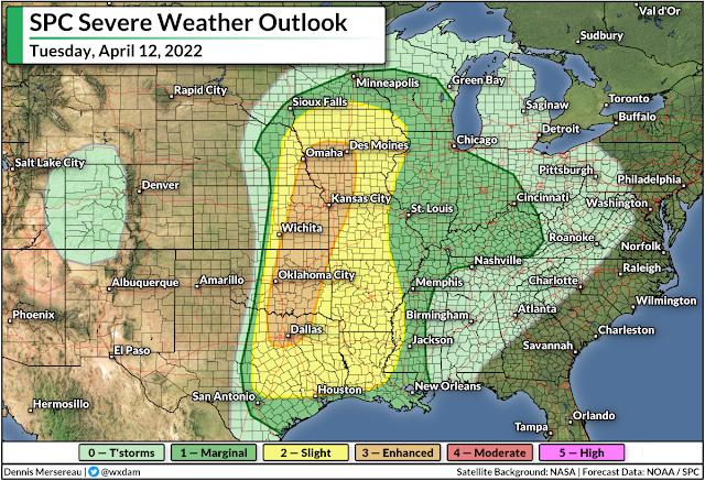
We’ll likely see several batches of severe thunderstorms crop up on the Plains during the day on Tuesday. A cold front and a dryline will serve as the focus for most of the thunderstorms that form. Many of the storms will start off as discrete cells capable of producing tornadoes, damaging winds, and large hail. The storms will eventually coalesce into a large squall line, at which point the main threat will shift to damaging winds with some tornadoes.
Tuesday’s storms will carry the risk for significant severe weather—including strong, long lived tornadoes; wind gusts of 70+ mph; and hail the size of golf balls or larger.
The risk for severe weather will continue into Tuesday night and early Wednesday morning for many of the communities at risk. Nighttime severe weather is especially dangerous because many folks are tuned out and it’s difficult to see hazards coming your way when it’s dark out.
Make sure you have a way to receive severe thunderstorm and tornado warnings if you’re asleep or otherwise tuned out. Check your phone and ensure that emergency alerts are activated for tornado warnings. Always trust the warnings and never wait to see danger for yourself before you act.
Wednesday
We’ll see the risk for severe thunderstorms shift east for the day on Wednesday, with portions of the Lower Mississippi Valley and the Deep South seeing the greatest threat for severe thunderstorms.
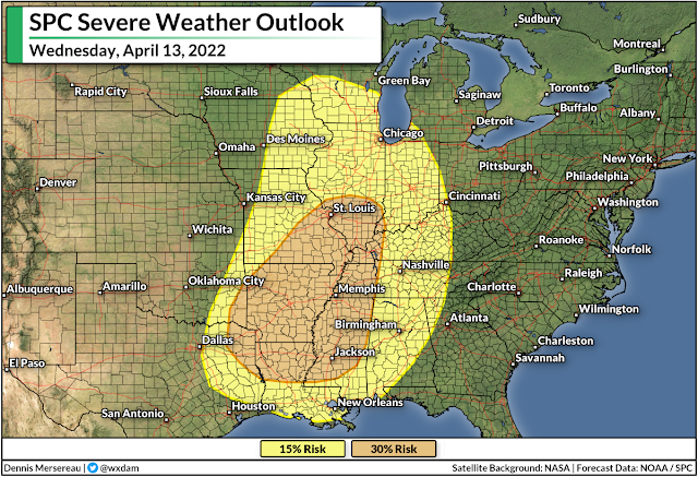
Since this is four days out, it’s too far for the Storm Prediction Center to use its categorical scale. Wednesday’s forecast instead uses probabilities. A 30% probability for severe weather four days out is pretty hefty, and folks in and around the risk areas should take note and start preparing now for all modes of severe weather.
Flooding Risk
Severe thunderstorms aren’t the only hazard we’ll see this week. Heavy showers and thunderstorms rolling over the same areas for several days on end will lead to a risk for flash flooding, especially across portions of the Lower Mississippi Valley and the Deep South. The risk for flooding will coincide with the risk for severe weather on Tuesday and Wednesday.
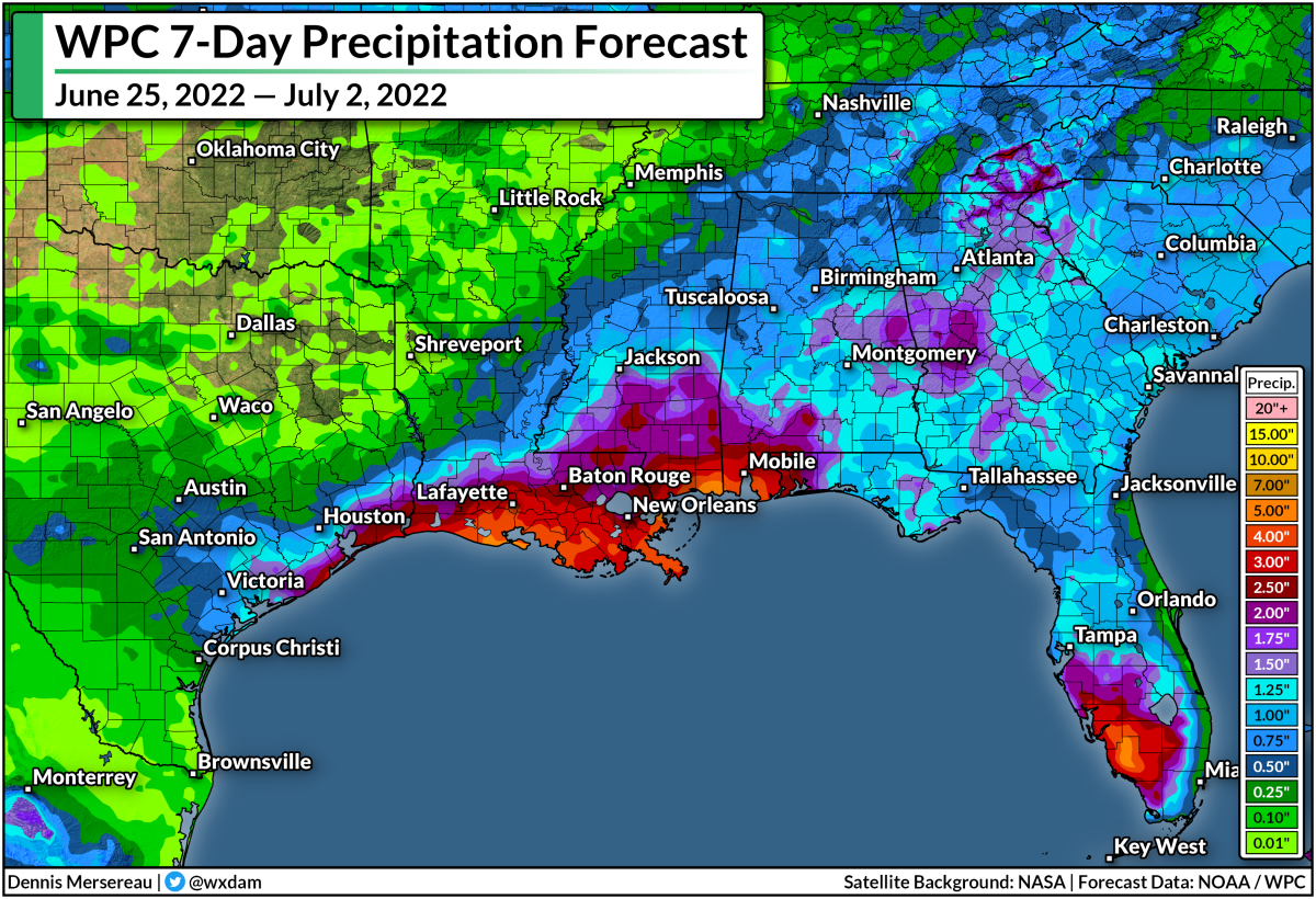
The Weather Prediction Center calls for several inches of rain across the hardest-hit areas. Too much rain falling all at once could easily overwhelm local waterways and drainage systems, leading to flooding in vulnerable areas. Keep a close eye for flash flood warnings and plan alternate ways to get around if you have to go out during or after the storms.
Heavy Snow/Blizzard Conditions
The storms and heavy rain are only one half of this sprawling storm. We’re going to see heavy snow and a period of blizzard conditions on the northern side of the low-pressure system.
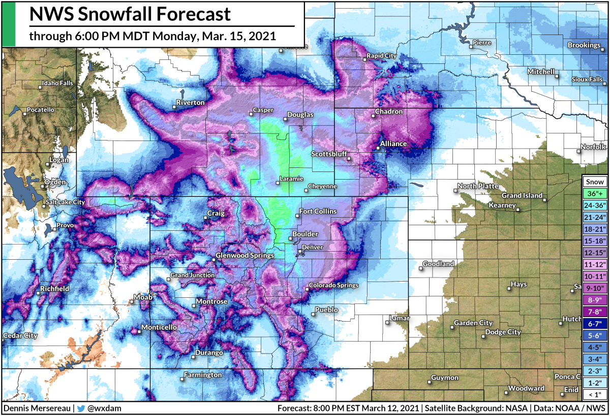
Cold air rushing down from Canada will allow for several days of heavy snow to fall across the northern Rockies and the northern Plains. We’re on track to see more than a foot of snow across a wide swath of the Dakotas. High winds of 40+ mph will lead to periods of blizzard conditions for the hardest-hit areas. Travel will be dangerous if not impossible during heavy snow and blowing snow.
It’s important to note that the National Weather Service’s forecast above stops Wednesday morning as the storm is still raging. These hefty snowfall totals will spread east deeper into eastern North Dakota and western Minnesota through the day on Wednesday and Thursday.
Fire Risk
As if blizzards and tornadoes aren’t enough, there’s a wildfire risk to go along with this classic springtime storm. Dry, gusty winds behind the system will blow across parts of the southwest and southern Plains, leading to a risk for critical fire weather conditions just about every day this week.
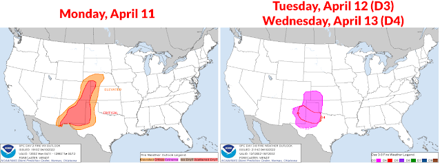
The risk for favorable fire weather conditions—warm temperatures, gusty winds, low humidity, and dry fuels—will persist each day Monday through Thursday, mainly centered on eastern New Mexico, far eastern Colorado, and western portions of Texas, Oklahoma, and Kansas.
There aren’t too many people out this way, but given the favorable conditions and ongoing drought, even the smallest fire can run away and threaten homes in a hurry.
[Top image created using WSV3]
You can follow me on Twitter or send me an email.
Please consider subscribing to my Patreon. Your support helps me write engaging, hype-free weather coverage—no fretting over ad revenue, no chasing viral clicks. Just the weather.