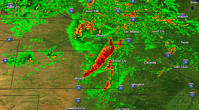
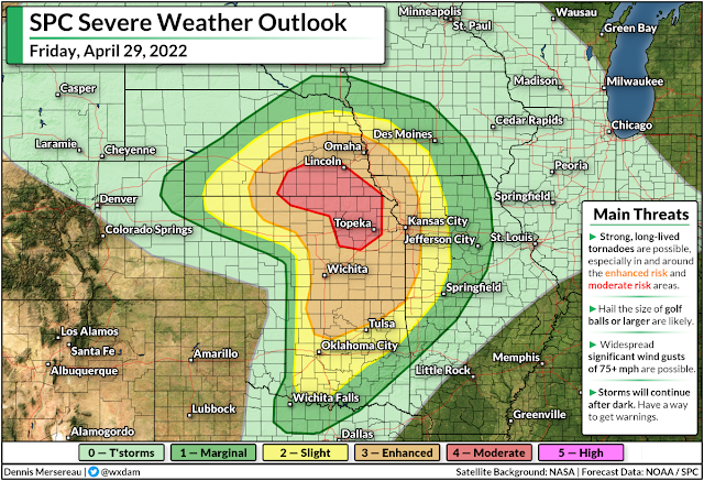
We're looking at the potential for some dangerous severe thunderstorms across the central Plains on Friday, with storms sparking in the late afternoon hours and continuing after dark for many areas. The greatest threat for significant tornadoes, powerful wind gusts, and very large hail will cover portions of Kansas and Nebraska, including several major population centers.
A strong Colorado low ramping up across the middle of the country will set the stage for the powerful storms expected to form on the Plains later today.
It's a classic mid-spring setup—warm, humid air will provide plenty of fuel for thunderstorms to quickly grow severe, and there's enough wind shear to quickly organize the initial round of thunderstorms into supercells.
Friday's potential for severe weather is maximized near the center of the low, where the Storm Prediction Center issued a moderate risk for severe weather—a four out of five on the categorical scale measuring the threat and extent of severe storms.
The threat extends out from there to include areas under the enhanced risk, as well, which covers Omaha and Lincoln; Topeka, Wichita, and the Kansas City metro; and extending down toward Tulsa and Oklahoma City.
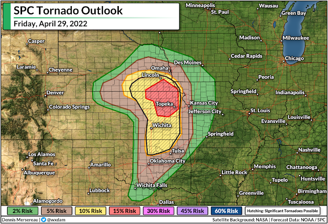
We'll see the greatest tornado threat occur with the initial thunderstorms, which could quickly organize into supercells.
The strongest supercells could produce significant, long-lived tornadoes, hail the size of golf balls or larger, and powerful wind gusts. The risk for significant tornadoes stretches from southeastern Nebraska to northern Oklahoma, including Lincoln, Topeka, and Wichita.
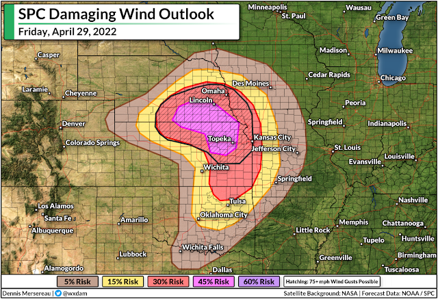
As the evening wears on, and as we see so often with setups like this, the supercells will eventually begin to merge and storms will coalesce into one or more squall lines.
At this point, the predominant threats will transition to powerful wind gusts of 75+ mph and a threat for embedded tornadoes. Don't sleep on a damaging wind threat—straight-line winds can cause as much damage as a tornado across a wider area.
Storms will continue after sunset, especially for areas in the eastern half of the risk zones, including the Kansas City metro area.
Severe weather at night is especially dangerous because folks are tuned out and starting to go to bed, making it difficult to receive severe thunderstorm and tornado warnings in a timely manner.
Make sure you have a way to receive warnings the moment they're issued. Take a moment to check your phone and ensure that wireless emergency alerts are turned on for tornado warnings. These free push alerts are proven lifesavers and often alert you to a tornado warning for your location before any other app.
[Top image created using WSV3]
You can follow me on Twitter or send me an email.
Please consider subscribing to my Patreon. Your support helps me write engaging, hype-free weather coverage—no fretting over ad revenue, no chasing viral clicks. Just the weather.
Please consider subscribing to my Patreon. Your support helps me write engaging, hype-free weather coverage—no fretting over ad revenue, no chasing viral clicks. Just the weather.


0 comments: