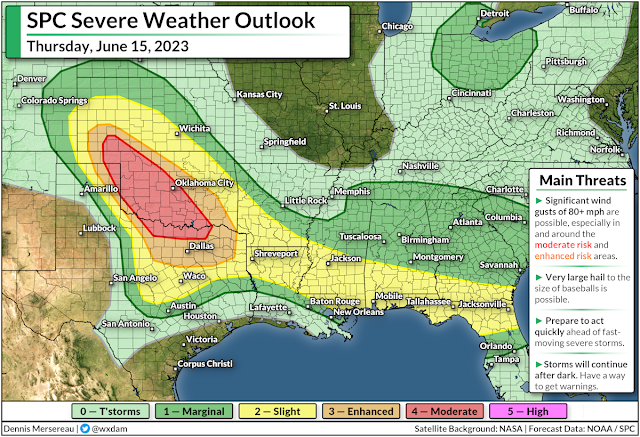
Baseball size hail and 80+ mph winds likely on the southern Plains Thursday
An unusually intense mid-June severe weather outbreak looms for the southern Plains on Thursday. Storms will sweep across much of Oklahoma through Thursday evening before pushing into Texas and heading toward the Mississippi River after dark.
Widespread significant wind gusts of 80+ mph are possible, along with the risk for hail the size of baseballs or larger. This is a dangerous setup that could lead to lots of damage by sunrise on Friday. Keep an eye out for warnings in your area and get ready to seek adequate shelter if storms approach.
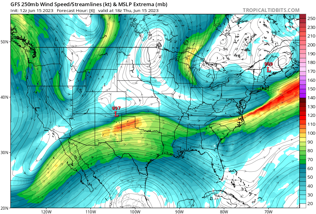
It’s unusual to have such a robust multi-day severe weather outbreak in the southern half of the United States at this time of year. Severe weather in the U.S. tends to migrate north as spring fades to summer and robust low-pressure systems follow the polar jet stream toward Canada.
 |
| Source: Tropical Tidbits |
However, a robust ridge of high pressure parked over Mexico pushed a strong sub-tropical jet stream over the southern half of the country. A very strong temperature gradient between the lower levels and the upper levels, combined with the potent wind shear aloft, set this uncharacteristic mid-June severe weather outbreak into motion.
We saw multiple high-end supercell thunderstorms roll through Mississippi, Alabama, Georgia, and Florida on Wednesday, complete with several large tornadoes and reports of huge hail and widespread wind damage.
The bulk of Thursday’s threat shifts back west of the Mississippi. The Storm Prediction Center issued a moderate risk for severe weather for a widespread chunk of Oklahoma, including the Oklahoma City metro area, as well as a chunk of northern Texas that includes Wichita Falls. An enhanced risk stretches down to include the entire DFW area.

Very strong instability and wind shear will allow storms to organize in a hurry. The greatest tornado risk will fall across western Oklahoma as storms fire up on Thursday afternoon. These individual cells have the best opportunity to turn into supercells that can fully engage with the environment and possibly put down some tornadoes, hopefully keep that nonsense in unpopulated areas.
As the storms pick up in coverage, they’ll likely merge into one or more clusters that begin marching east and southeast into the evening hours. These clusters will carry a significant risk for destructive wind gusts of 80+ mph and hail possibly reaching the size of baseballs or larger.
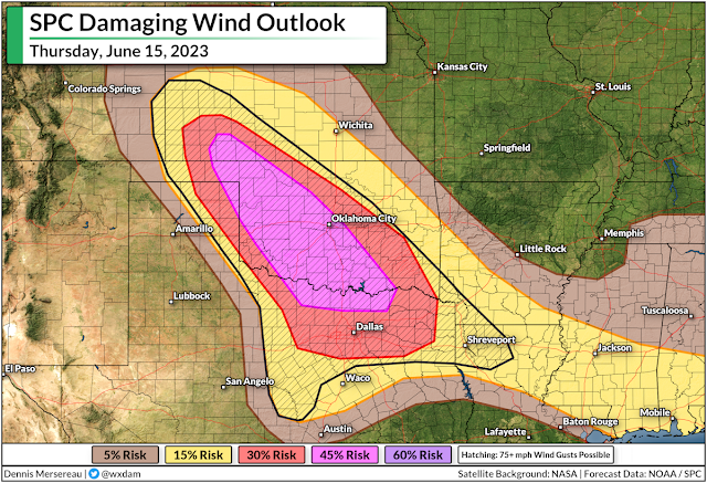
Winds that strong alone can cause widespread damage to trees, power lines, and structures. Add very large hail into the mix and it’ll increase the risk for damage.
It’s likely we’ll see some cases of wind-blown hail totaling vehicles, shattering windows, and possibly even punching through walls and roofs. It’s no joke. “Stay in an interior room away from windows” appears in severe thunderstorm warnings for a reason.
If you’re in the region, check your phone’s settings to make sure wireless emergency alerts are activated and ready to receive the most urgent severe weather alerts for your location. Lots of folks shut these off after one ill-timed interruption, but they’re proven lifesavers that are cited time and again in post-storm surveys as directly saving the lives of families who survived horrible storms.
These storms will move quickly and much of the threat for severe weather, especially east of I-35, will occur after dark. Make sure you’ve got a way to receive severe weather alerts once you’ve settled in for the night and after you’ve gone to bed.


