Skip to content
DAMWeather DAMWeather DAMWeather

The weather can get scary. Reporting on it doesn't have to be.

DAMWeather DAMWeather DAMWeather

The weather can get scary. Reporting on it doesn't have to be.

  • About Me
  • All Bylines
    • Books, Bylines, and Press
    • The Skies Above (Book)
    • Extreme Weather (Book)
    • The Weather Network
    • The Vane
    • Forbes
    • Capital Weather Gang
    • Mental Floss
  • Maps
    • Hurricane Maps
    • Hurricane Names
    • Monthly Tornadoes
    • Tornado Tracks
    • F5/EF-5 Tornadoes
    • SPC High Risk Days
  • GIS Resources
  • Contact Me
    • Bluesky
    • Facebook
    • Instagram
  • wxdam.com

Tropical Storm Bret aims for the Caribbean with another system on its heels

By Dennis Mersereau
June 20, 2023 3 Min Read

It’s the middle of June and the tropics are acting like it’s August.
Tropical Storm Bret formed deep in the tropical Atlantic Ocean on Monday, becoming one of just a tiny handful of storms on record to form east of the Lesser Antilles this early in hurricane season.
Bret is a classic storm…for the middle of hurricane season. The storm formed from a tropical wave that rolled off the western coast of Africa. Faced with warmer-than-usual sea surface temperatures and favorable moisture and wind shear, the disturbance grew into our second named storm of the year.

Forecasters with the National Hurricane Center (NHC) expect Bret to hit the Lesser Antilles as a high-end tropical storm on Thursday. Tropical storm watches are in effect for Barbados and Dominica ahead of the the storm’s arrival, where high winds and heavy rains could cause some flooding and power outages.
Bret’s on borrowed time, fortunately, as increasing wind shear over the eastern Caribbean should tear the storm to shreds by the end of the week.
Hot on its heels, though, is a similar disturbance that forecasters give an 80 percent chance of developing over the next couple of days. This system, dubbed Invest 93L for tracking purposes, will probably follow a track a little farther north than the one Bret is on, and it should suffer a similar fate by the weekend, falling apart in the face of disruptive wind shear. If that system becomes a tropical storm, it would earn the name Cindy.
What on earth is going on?
It’s extremely unusual for storms to develop this far out in the Atlantic Ocean this early in the year. Hurricane activity tends to follow a predictable trend as the season progresses. Systems that form in June tend to develop close to the U.S. and Mexico, sprouting from seeds like stalled cold fronts and decaying clusters of thunderstorms that roll offshore.
SOURCE: National Hurricane Center

Usually it’s not until July and August that we start to see tropical activity pull farther out into the Atlantic basin, with conditions over the Atlantic becoming more hospitable to the tropical waves that roll off the western coast of Africa during the sub-Saharan summer monsoon.
Things happened to line up just right this year, defying the odds to give us at least one—possibly two—named storms far outside where they’re supposed to form in June.
SOURCE: NOAA

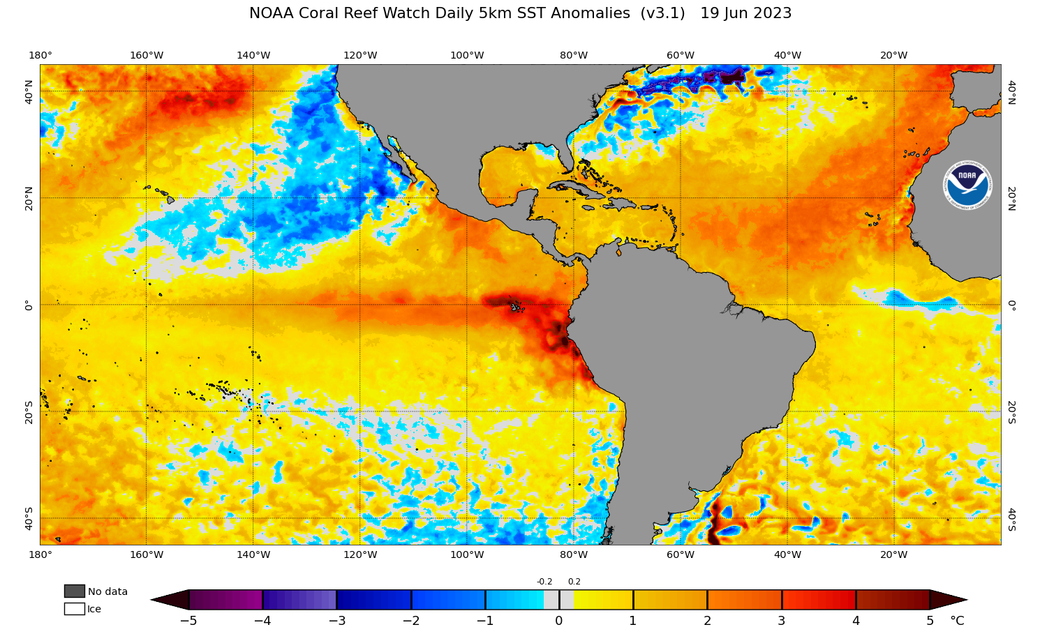
Sea surface temperatures across the entire Atlantic Ocean are exceptionally toasty, with much of the basin coming in 1-2°C warmer than normal for the middle of June. This kind of abnormal warmth across the Atlantic is unprecedented in its intensity and coverage.
We’re also entering a formidable El Niño in the eastern Pacific Ocean. This pattern of warmer-than-normal sea surface temperatures off the west coast of South America tends to generate destructive wind shear that disrupts the Atlantic hurricane season.
However, given just how toasty the Atlantic is this year, it’s hard to tell how much El Niño will actually affect hurricane activity this year. If the Atlantic’s warm spell keeps up, we could have a busy season on our hands despite the historical odds against it.


You can follow me on Facebook, Mastodon, Twitter, Instagram, or send me an email.

Please consider subscribing to my Patreon. Your support helps me write engaging, hype-free weather coverage—no fretting over ad revenue, no chasing viral clicks. Just the weather.


Author

Dennis Mersereau

I have 15+ of experience providing hype-free weather information for folks across the United States and around the world. In addition to DAMWeather, I also contribute to The Weather Network as a digital writer and weather specialist.

Follow Me
Other Articles
Previous

Dangerous heat, dangerous storms continue as bizarre pattern persists

Next

Conspiracy theories are security blankets for scared adults, and they’re suffocating us


Local ◈ UTC
Facebook | Bluesky
Instagram | Threads | Email
DAMWeather is now ad-free! Everyone benefits from engaging, hype-free weather coverage. Please consider supporting my efforts through Patreon:


Order The Skies Above today!

Bookshop.org || Barnes & Noble
Mountaineers Books || Amazon

My latest book, The Skies Above, is now available!

Did you know a puffy cloud can weigh millions of pounds? Or that every rainbow you see is unique to you?

Our atmosphere is full of spectacular sights that are always within your reach. Glistening layers of fog, gorgeous sunsets, and brilliant meteors flashing through the sky can light up even the calmest day.

The Skies Above, published by Mountaineers Books, is a celebration of what we overlook when we look up. I was thrilled to work with the editors and illustrators at Indelible Editions to share with you the quotidian beauty of our sky.

Order your copy now and learn about the wonders we take for granted every day.

I teamed up with the editors of Outdoor Life magazine to write The Extreme Weather Survival Manual, your guide to surviving and thriving in almost any weather condition. Whether you're an avid outdoorsperson or you enjoy watching the radar from the comfort of your home, you're sure to find helpful tips, advice, and new bits of knowledge in this fascinating book.

You can buy my book today through Amazon.
An error has occurred, which probably means the feed is down. Try again later.
  • 2026 (30)
  • 2025 (49)
  • 2024 (59)
  • 2023 (43)
  • 2022 (57)
  • 2021 (71)
  • 2020 (83)
  • 2019 (88)
  • 2018 (92)
  • 2017 (1)
  • 2016 (4)
  • 2015 (10)

Copyright 2026 — DAMWeather. All rights reserved. Blogsy WordPress Theme