Dangerous heat, dangerous storms continue as bizarre pattern persists
Dangerous weather will continue rolling through the weekend and into next week as a freaky pattern for the middle of June stubbornly holds out over the southern United States.
Additional rounds of powerful storms will persist over the next couple of days, alongside an unseasonable slug of unbearable heat parked over Texas.
Day after day of severe thunderstorms have put tremendous stress on the southern states this past week. We’ve had deadly tornadoes, tremendous amounts of destructive hail, flash flood emergencies, and widespread wind damage as one wave of destructive storms after another swept from the southern Plains to the northern Gulf Coast.
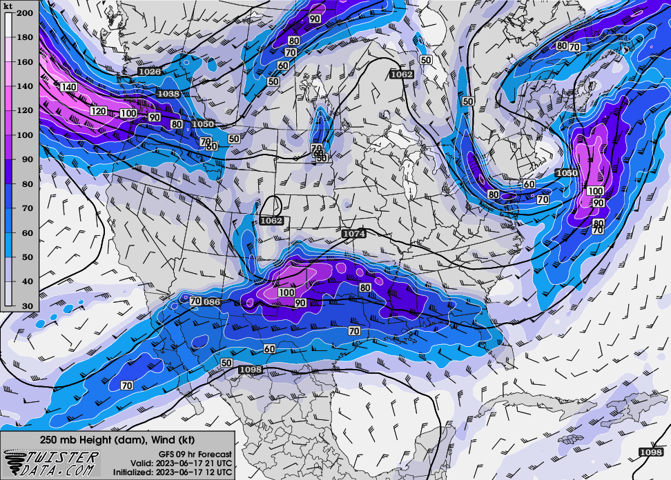 |
| SOURCE: Twister Data |
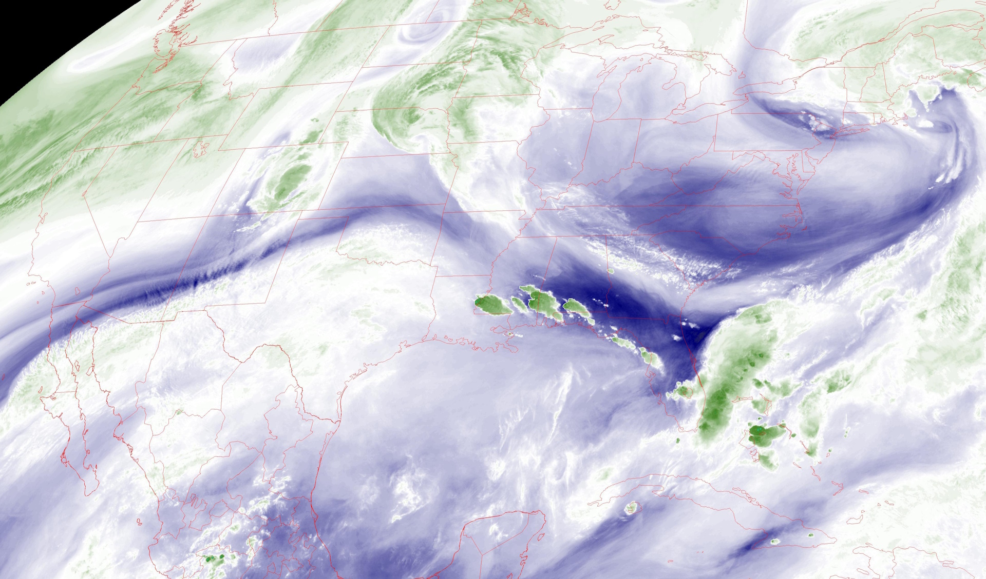
All of the hubbub is the result of a subtropical jet stream locked over the region, the result of a very strong upper-level ridge of high pressure standing tall over Mexico.
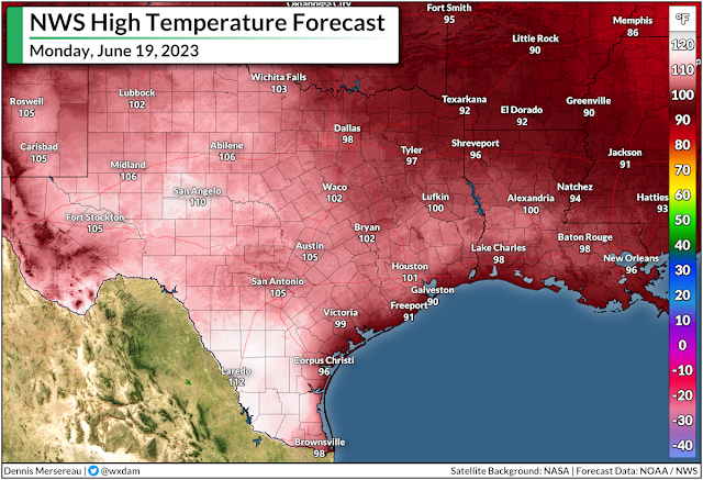
Beneath the ridge, extremely hot and humid temperatures have bathed much of Mexico and Texas in recent days, with daytime highs easily exceeding 100°F and heat indices climbing to 110-115+ during the day.
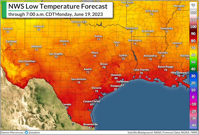
This heat will continue into next week, with highs in the 100s a common sight across much of southern and southeastern Texas into the middle of next week. It’s not bad enough that the days are so incredibly hot—it’s that the extreme humidity is preventing nights from providing any relief at all.
Dew points in the upper 70s are preventing nighttime lows from dipping much below 77-80°F.
Heat waves like this are compounding disasters. Folks without access to air conditioning rely on nights for some relief from the unbearable heat.
One or two days is survivable, but when you get into 5+ days of stifling days and putrid nights, it will start to take a significant physical toll on vulnerable individuals.
The outer edge of that heat dome parked over Texas is serving as the focus for all of those rowdy thunderstorms we’ve seen all week. We typically don’t see such a dynamic setup in the south this late in the year. The combination of summertime temperatures with a springtime severe weather setup has resulted in violent thunderstorms, an adjective that seems like it’s an understatement.
Extreme instability has fueled raucous thunderstorms that are able to organize and intensify thanks to that unusual wind shear present over the region.
During more normal times, these storms would just be those typical summertime drenchers that pop up during the day and fizzle out around sunset. That wind shear has allowed these storms to structure themselves into hail-churning wind machines, with golfball size hail and 70+ mph wind gusts a common sight.
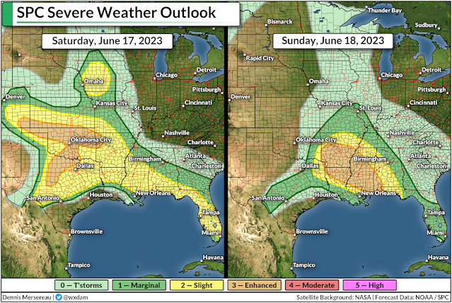
The Storm Prediction Center highlights additional risks for severe weather on Saturday, Sunday, and Monday, covering the exact same areas battered by relentless storms since early this past week.
We’ll finally start to catch a break on all fronts by the middle of the week, thankfully, as the pattern breaks and allows that ridge to weaken. This long-deserved progression in the upper levels of the atmosphere will allow the heat to subside to a more seasonable muck over Texas, while defusing the turbocharged environment that’s allowed terrible storms to flourish.
[Top Image: A water vapor image of the U.S. on June 17, 2023, highlighting the ridge over the south responsible for all the nonsense of late, via NOAA.]


