The only thing scarier than a strong hurricane threatening a major metro area is a strong and slow-moving hurricane threatening a major metro area.
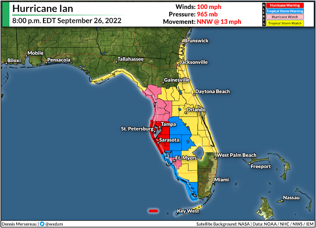
Hurricane warnings are in effect for the Tampa Bay area this evening as Hurricane Ian makes a beeline for the area.
The storm is going to grow very strong by the middle of the week as it approaches Florida's west coast. As if that's not bad enough, the storm is also going to slow down to a crawl as it parallels the peninsula, prolonging the high winds, heavy rain, and storm surge to 24+ hours for many areas.
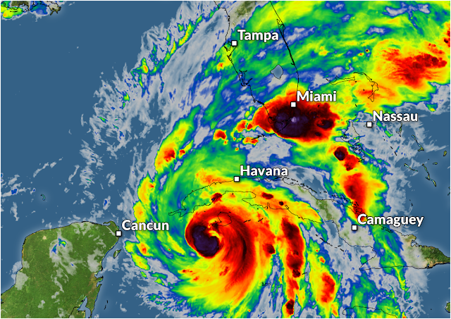
Hurricane Ian wound up in a hurry as it trekked through the western Caribbean Sea over the past couple of days. The storm is now a category two hurricane with maximum winds of 100 mph, and it's in a favorable environment for continued strengthening over the next couple of days.
The storm will make landfall on the western tip of Cuba overnight Monday before emerging in the southern Gulf of Mexico on Tuesday.
Forecasters with the National Hurricane Center (NHC) expect Ian to rapidly intensify as the storm hits the steamy waters of the southern Gulf, with the official forecast strengthening Ian into a frightening category four hurricane by Tuesday night.
Then the storm is going to hit the brakes.
 |
| SOURCE: Tropical Tidbits |
A strong ridge of high pressure building over the Great Lakes will act like a barricade that will slow Hurricane Ian down to a crawl.
This thing is only going to be moving a couple of miles per hour as it approaches Florida's west coast. The forecast icons are practically on top of each other by the time the core of the storm is close to Tampa Bay.
Storm Surge
It may seem like a good thing that the storm isn't going to haul into Florida at full strength, but all things are relative with such a strong storm in such a vulnerable area.
 |
| SOURCE: National Hurricane Center |
If the current forecast holds, this would expose the Tampa Bay area to the strongest part of the storm for an entire day or longer, funneling a deep and persistent storm surge into the bay and directly into the city of Tampa itself.
The NHC's storm surge forecast at 5:00 p.m. on Monday called for a 5-10 foot storm surge across the Tampa Bay area if the strongest winds in the storm coincide with high tide. This would be a destructive storm surge for coastal areas, and a double-digit surge would push well inland from the coast in spots.
Flooding Rains
Flooding from heavy and persistent rains is going to be one of the biggest impacts from this storm as it makes landfall and pushes inland through next weekend.
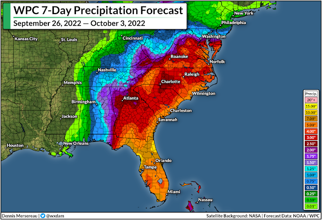
We could see rainfall totals of 6-12+ inches across the Florida peninsula during this storm. That much rain will easily overwhelm waterways and storm sewers, leading to flooding in vulnerable areas.
The heavy rain isn't going to stay limited to Florida, though. After landfall, Ian and its eventual remnants will slowly make their way into the southeast, where we're likely to see widespread heavy rain starting at the end of the week and lasting into the weekend.
A surge of tropical moisture riding on the back of a remnant storm is enough to prompt flooding rains under normal circumstances, but that same high-pressure system that will slow Ian to a crawl is also going to lead to a significant cold air damming (CAD) event across interior sections of the southeast.
 |
| SOURCE: Tropical Tidbits |
Cold air damming occurs when northeasterly winds blow cool air up against the base of the Appalachian Mountains. The cold, dense air can't ride up and over the mountains, so it pools up across the piedmont region. It's infamously stubborn and approaching storms have a tough time scouring it away—warm air winds up riding up and over this dammed-up cold air, triggering widespread rainfall.
A persistent conveyor belt of tropical moisture flowing up and over that cooler air at the surface will lead to several days of heavy rain, which could easily lead to flooding in vulnerable areas. There's also the potential for landslides in some of the Appalachians.
Winds
Hurricane-force winds are likely across the west-central Florida coast. Widespread and potentially long-lasting power outages are likely for the hardest-hit areas, especially if 100+ mph sustained winds manage to move ashore.
One of the most important preparations you can make for an approaching storm is getting ready for power outages. You never realize how underprepared you are until the lights go out.
Actual flashlights and battery refills are crucial so you don't waste your cell phone battery feeling your way around the bathroom.
Non-perishable, ready-to-eat foods like canned ravioli and fruit cups are a lifesaver when there's no power. It's tough to cook without electricity and the burger joints and coffee shops won't be open if they don't have power.
Tornadoes
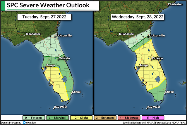
As with any landfalling tropical system, a risk for tornadoes will spread inland as the storm very slowly approaches landfall over the next couple of days.
Tornadoes are common in the right-front side of tropical cyclones because there's ample low-level wind shear to spark rotation in thunderstorms embedded in the storm's outer bands. Tropical tornadoes happen very quickly, sometimes only allowing forecasters to issue tornado warnings with only a minute or two of lead time.
Make sure you have a way to receive tornado warnings the moment they're issued, and have a plan to get to safety as quickly as possible if you hear that your location is under a tornado warning. Take a look at your cell phone now to ensure that wireless emergency alerts are turned on for tornado warnings. Lots of folks shut them all off after one ill-timed interruption for an AMBER Alert.
Tampa's Century-Long Lucky Streak Looks Finished
Tampa is one of the only major coastal cities in the south that's been relatively lucky when it comes to hurricanes. Plenty of storms have come close and even tracked over the area. Hurricane Zeta made landfall north of the bay area as a tropical storm in November 2020.
 |
| SOURCE: NOAA |
The last time a major hurricane came close to Tampa Bay was an unnamed storm back in 1921. That storm caused widespread destruction across the region. Hurricanes tend to miss Tampa because prevailing winds tend to force storms to hit Florida from the east, and (with one recent exception) storms approaching from the south typically only clip the area on their way to the northern Gulf Coast.
Geography isn't protection. All indications are that Tampa's century-long lucky streak on missing strong hurricanes is going to fall this week. Please heed the advice and orders of local officials if you live in a vulnerable area, and please let your friends and family in the area know that this is a serious situation.
You can follow me on Twitter or send me an email.
Please consider subscribing to my Patreon. Your support helps me write engaging, hype-free weather coverage—no fretting over ad revenue, no chasing viral clicks. Just the weather.
Please consider subscribing to my Patreon. Your support helps me write engaging, hype-free weather coverage—no fretting over ad revenue, no chasing viral clicks. Just the weather.


0 comments: