Tropical Storm Fred Strengthens Near Landfall, Tornado Risk Increases Over Southeast

Tropical Storm Fred was dead yesterday…meteorologically speaking, anyway. But Fred managed to fight through wind shear and blew up into a strong tropical storm today as it heads toward the Florida Panhandle. The storm is really going for it, and it could be on the verge of hurricane strength by the time it makes landfall Monday afternoon.
Fred is the perfect example of why we need to pay such close attention to storms when they’re close to land.
If you last checked the weather at 7:00 a.m. on Sunday morning, you saw a sad blob of clouds called the “remnants of Fred.”
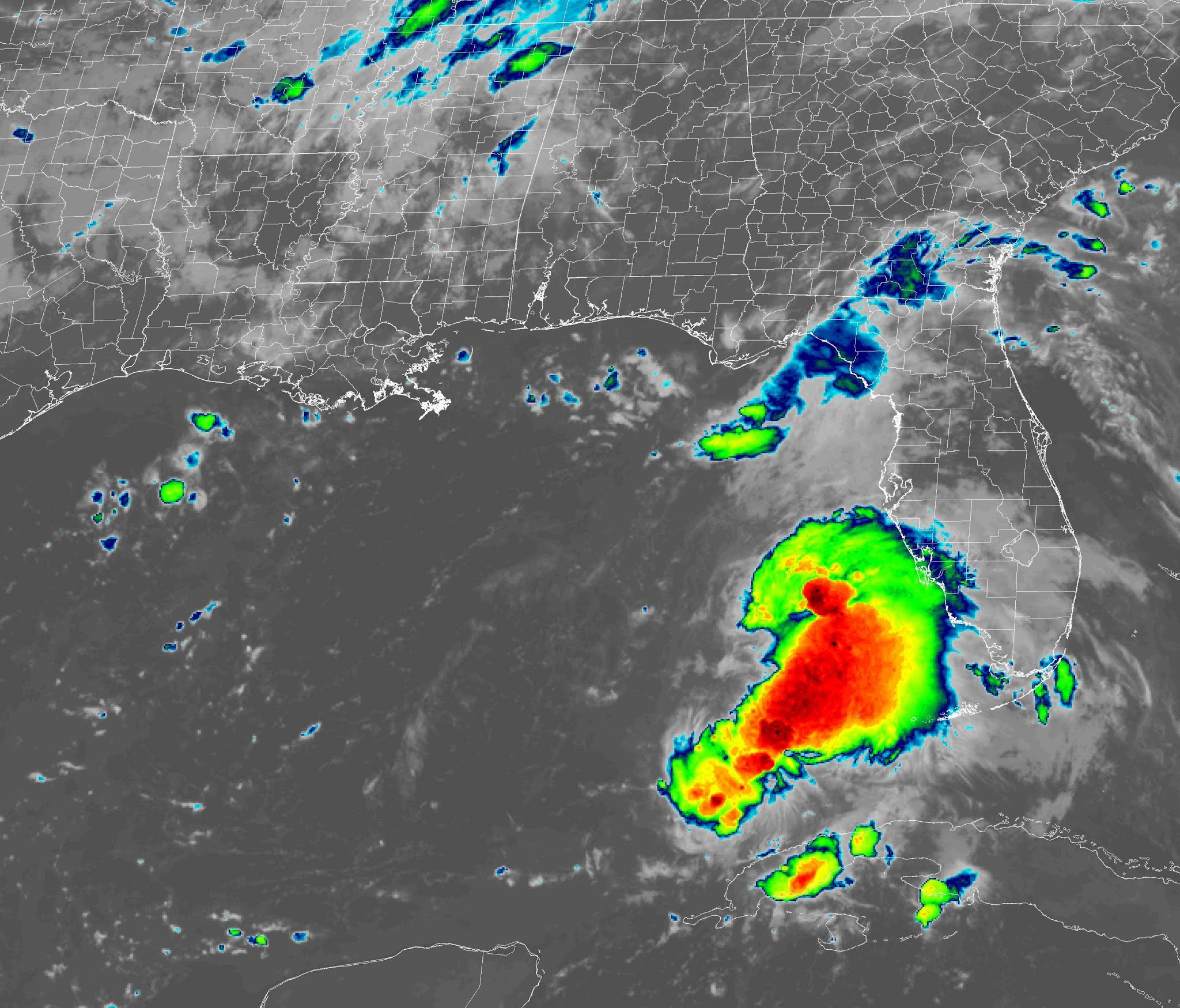
The storm degenerated into an open tropical wave and it was no longer a tropical cyclone.
If you checked the weather again exactly 24 hours later, at 7:00 a.m. on Monday, you could swear you were looking at a completely different storm:
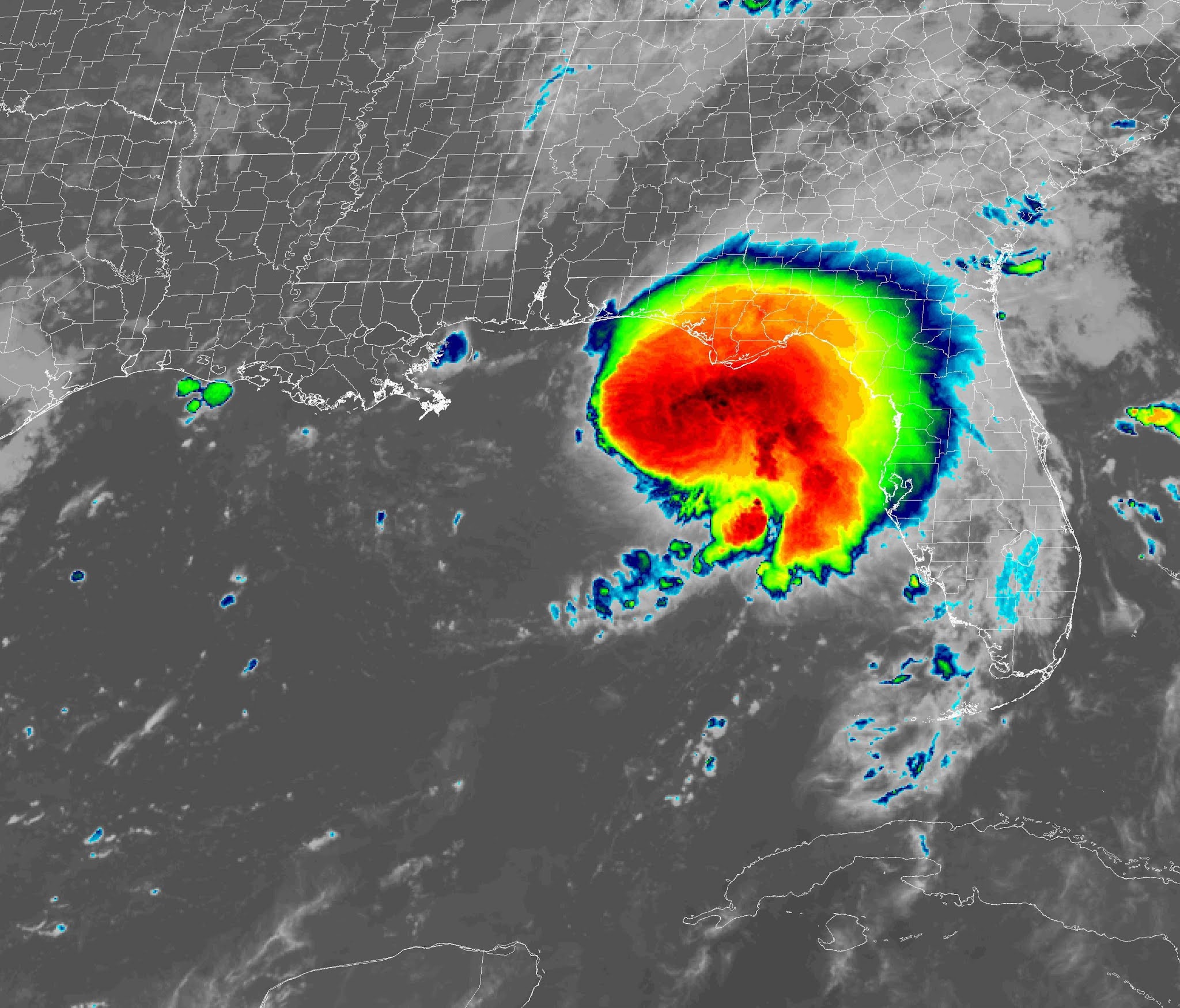
Fred looks even more organized this afternoon, with pronounced rain bands, transverse banding (the sawtooth ripples in the cirrus clouds above the storm), and an ominous swirly shape wrapping around the core of the storm.
Scary, huh?
Tropical cyclones can organize and intensify in a very short period of time. It’s incredibly important to check the weather several times a day when a storm is close to land. This isn’t the first storm to make a run for it as it neared landfall—it seems to happen at least once every year these days, and we saw a rapid intensity jump with just about every landfalling storm in 2020.

Fred had 65 MPH winds at the 2:00 p.m. advisory from the National Hurricane Center. The storm might not make it to hurricane strength before landfall, but it’s certainly not for a lack of trying. Fred doesn’t have much water left to take advantage of before it makes landfall southwest of Tallahassee.
The storm’s newfound strength and structure will make it more durable as it pushes inland, which will heighten the threat for heavy rain, gusty winds, and tornadoes along the storm’s track over the next few days

The Weather Prediction Center expects 3-5″ of heavy rain to follow Fred inland, with the highest totals near the coast and along the Appalachians from Georgia through Virginia. Raindrops from tropical cyclones are very tiny, so it doesn’t take much of a rain band to produce high rainfall rates.

There’s also a risk for tornadoes along and to the east of the storm’s track. The tornado risk has ratcheted up given Fred’s sudden strengthening and organization. A risk for tornadoes will exist from the point of landfall in Florida up into western Virginia through Tuesday.
The map above shows the Storm Prediction Center‘s severe weather outlook for both Monday and Tuesday. The convergence of Monday’s outlook and Tuesday’s outlook near Atlanta means that the threat will move through the Atlanta area early Tuesday morning.*
Remember, tropical tornadoes often happen quickly and there’s usually lower tornado warning lead time as a result. Stay close to safe shelter if you’re near the track of the storm as it pushes inland over the next few days. Check your smartphone now and ensure that wireless emergency alerts are activated for tornado warnings. This feature is a lifesaver during tornadoes.
[Satellite Image: NOAA]
*Today’s severe weather outlook ends at 7:00 a.m. EDT tomorrow, and tomorrow’s severe weather outlook picks up from there. The SPC issues products on Coordinated Universal Time (UTC).
You can follow me on Twitter or send me an email.
Please consider subscribing to my Patreon. Your support helps me write engaging, hype-free weather coverage—no fretting over ad revenue, no chasing viral clicks. Just the weather.

